 Cave Creek Church
 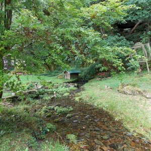 Chinn Spring
 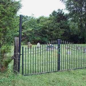 Chinn Spring Cemetery
 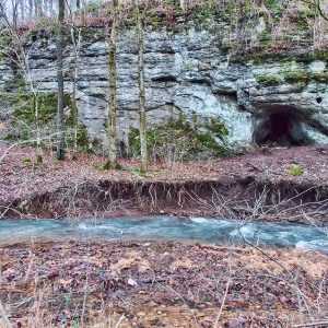 Chinn Spring Cave
 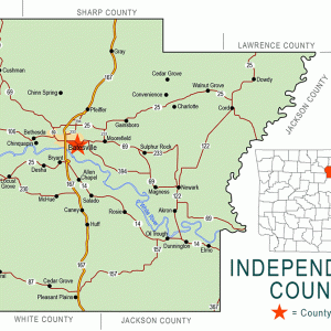 Independence County Map
 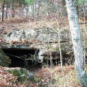 Saltpeter Cave
501-918-3025
calsfoundation@cals.org
calsfoundation@cals.org
A popular place for church and social picnics in the late 1800s and early 1900s, Chinn Spring is located on Cave Creek in Ashley Township on Chinn Spring Lane just east of Polk (or Poke) Bayou. The community of Chinn Spring emerged near the spring. The Will Chinn Cave is located in this vicinity. Batesville (Independence County), the county seat, is located about five miles south of Chinn Spring. Today, the spring is located on private property owned by a Batesville businessman.
John French Chinn was born in 1810 in Fauquier County, Virginia, where, in 1832, he married Lydia Elizabeth Byrne. Following the death of Chinn’s parents, the two moved to Ruddell (Independence County) around 1847. On the 1860 census, the family was living at the spring that bears the Chinn name. The post office is listed as Batesville, as Chinn Spring never had its own post office. The Chinns had sixteen children. John Chinn died on October 7, 1875, at Chinn Spring; he and his wife are buried in Chinn Cemetery.
The community of Chinn Spring was so isolated that not much action took place there during the Civil War, but Saltpeter (a.k.a. Salt Peter) hamlet and cave near what is today Cushman (Independence County), about seven miles north-northeast of Chinn Spring, was a primary source of saltpeter for the Confederacy, and Rebels worked the mine in 1861–1862. (Potassium nitrate, or saltpeter, is a naturally occurring mineral that is vital to the production of gunpowder.) Transportation, labor supply, and security of operations proved difficult in the mining endeavors, and thus the saltpeter works were gradually phased out. By September 1863, saltpeter mining operations had moved to Texas, but Confederate guerrillas kept the mines open at Saltpeter till the end of the war.
By 1849, a large range of manganese ore deposits had been discovered in northwestern Independence County, with a spillover into Sharp, Izard, and Stone counties. This discovery came to be labeled the Batesville District, with Cushman at its center; the district also contained the Chinn Spring region. In 1885, the Keystone Mining Company (owned by Andrew Carnegie) and the St. Louis Mining Company began operations in the Southard Hill region northeast of Chinn Spring. This marked the beginning of significant mining in the area. The Walter Chinn Prospects (a prospect is a manganese ore “dig”) and A. R. Chinn Prospect are located on Cave Creek near Pfeiffer (Independence County), about seven miles east southeast of Cushman. There is an active lime quarry today near Chinn Spring, the Midwest Lime Company off Highway 167 on Midwest Lane between the spring and Batesville.
Many local farmers in the Chinn Spring region would supplement their farm income by working for the mine operators who usually resided in Cushman or in Batesville. The farmers often owned mule teams and made agreements with the operators to haul ore for them. All this ended by 1959 when the government quit stockpiling manganese, and American steel plants came to rely on imported ore.
The Chinn Spring Cave (a.k.a. Will Chinn Cave) is listed as the third-longest cave in Arkansas after Fitton (Beauty) Cave in Newton County and Blanchard Springs Cave in Stone County. Chinn Spring Cave is nearly seven miles long and has a depth of 252 feet.
By 1903, a railroad spur was connected to a marble quarry near Chinn Spring, and a community called Pfeiffer grew up around the quarry. Cutting machinery and stone-quarrying equipment were added to make it a sizeable operation. The quarry was owned and operated by the Pfeiffer family of St. Joseph, Missouri, who never established a permanent home in the county but continued to use St. Joseph as the center for its stone company.
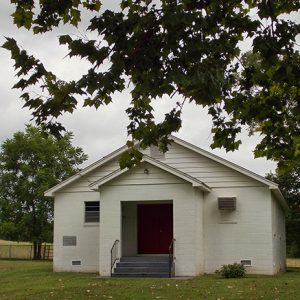
Cave Creek Church on Cave Creek Road in Modlin Hollow and the Cave Creek Church of God on Gum Lane are located in the community of Chinn Spring. Both are still active in the twenty-first century. Belleview School, serving grades 1–8, located east of what is today Chinn Spring Lane, was still active in 1936 but merged with Cushman and Batesville in the 1940s. Chinn Spring has three cemeteries: Chinn, Belleview, and Greenfield. Chinn Spring is a farming area, and there are no businesses in the community, although there are a few businesses in nearby Pfeiffer.
For additional information:
Johnston, James J. “Bullets for Johnny Reb: Confederate Nitre and Mining Bureau in Arkansas.” Arkansas Historical Quarterly 49 (Summer 1990): 124–167.
Kirk, Mrs. Elmer. “The Saltpeter Mine of 1862.” Independence County Chronicle 3 (April 1962): 3–9.
McGinnis, A. C. “A History of Independence County, Ark.” Special issue. Independence County Chronicle 17 (April 1976).
Wolf, John Quincy, Sr. “My Fifty Years in Batesville, Arkansas.” Independence County Chronicle 23 (October 1981–January 1982).
Shiras, Tom. “Manganese Mining in Arkansas.” Engineering and Mining Journal 105 (December 22, 1917).
Smith, Jim, and Becky Wood. The Cushman Manganese Mines and the Batesville Manganese District Arkansas. N.p.: 1995.
Spier, William. “A Social History of Manganese Mining in the Batesville District of Independence County.” Arkansas Historical Quarterly 36 (Summer 1977): 130–157.
Kenneth Rorie
Van Buren, Arkansas


Comments
No comments on this entry yet.