 Climate and Weather
 Divergent Prosperity and the Arc of Reform, 1968–2022
 Science and Technology
501-918-3025
calsfoundation@cals.org
calsfoundation@cals.org
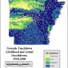
The tornado outbreak of March 1, 1997, was one of the deadliest in the history of the state of Arkansas. Sixteen tornadoes tracked across the state, killing twenty-five Arkansans. Several of the tornadoes had unusually long tracks, traveling between fifty and seventy-five miles. There was also a higher than statistically expected number of tornadoes of F3 strength or higher—that is, tornadoes with wind speeds in excess of 158 miles per hour.
Of the sixteen tornadoes, four were responsible for all fatalities in the state, as well as much of the property damage. All sixteen tornadoes were produced by four supercell thunderstorms, with the four killer tornadoes being spawned from two such storms that formed ahead of a cold front.
The Day
During the morning of March 1, atmospheric conditions were favorable for the formation of severe thunderstorms and possibly tornadoes. Warm, humid air from the Gulf of Mexico had settled over the state, causing temperatures, normally in the fifties during early March, to sit between seventy-two and seventy-five degrees. With dew points in the seventies as well, the air was heavy with humidity. Winds were strong, both at the ground and far above it, with directional wind shear noted. Wind shear, meaning the turning of winds with height, created rotation in the atmosphere, which made conditions even more favorable for the formation of tornadoes.
Another contributing factor to the day’s severe weather was a strong cold front pushing into the state from the northwest. Behind this front, temperatures were as low as the mid-thirties. This temperature contrast added even more instability to the atmosphere. By the morning of March 1, a line of thunderstorms had developed along the cold front as it pushed into the state; this line was responsible for producing several tornadoes. However, the stronger tornadoes were born from another line that developed approximately fifty miles ahead of the front and moved northeastward along the unstable boundary of warm and cold air.
Forecasting the Event
On February 28, the Storm Prediction Center in Norman, Oklahoma, issued a Day 2 moderate risk of severe weather for much of the state. At 11:34 a.m. on March 1, they issued Tornado Watch Number 75, which included western and central Arkansas as well as portions of neighboring states; this watch was issued approximately two hours and thirty minutes before the first tornado touched down in the state.
During the event, the National Weather Service weather forecasting office in North Little Rock (Pulaski County) issued fifty-seven severe-weather warnings; thirty-four of those warnings were for tornadoes. The average lead time those warnings gave communities that would be hit by killer tornadoes ranged from nine minutes in the Denmark (Jackson County) and Velvet Ridge (White County) areas to twenty-eight minutes in the Jacksonport (Jackson County) area. Overall, the time between issuance of a tornado warning and the arrival of one of the four killer tornadoes averaged about twelve minutes.
Notably, this marked the first time that a local meteorologist used radar to track a tornado live on television in the state of Arkansas. Ed Buckner of KTHV tracked one of the killer tornadoes through central Arkansas via the station’s “Live View Radar.”
Interstate 30 Supercell
One of the supercell thunderstorms to spawn multiple killer tornadoes became known as the “Interstate 30 Supercell” due to its path northeastward along Interstate 30. Multiple killer tornadoes were formed under this storm, as well as a few smaller satellite tornadoes.
The first killer tornado born from the Interstate 30 Supercell touched down near Hope (Hempstead County) at 1:55 p.m. and began a northeastern trek through rural Hempstead and Nevada counties before crossing into Clark County. This tornado struck Arkadelphia (Clark County) around 2:40 p.m., causing F4 damage, indicating winds between 207 and 260 miles per hour. Much of downtown Arkadelphia was destroyed, with sixty blocks of the city taking severe damage. In one trailer park, fifty-six out of fifty-seven mobile homes were destroyed. Overall, the tornado damaged or destroyed about 250 houses, ninety mobile homes, and forty-five businesses in the Arkadelphia area. The Clark County Courthouse also lost its capstone and clockwork. Five people were killed in Arkadelphia proper, with a sixth person being killed in a vehicle on Interstate 30 southwest of the city. From there, the tornado continued into Hot Spring County, causing significant damage in the Donaldson (Hot Spring County) area, before finally lifting about four miles east of Malvern (Hot Spring County) at approximately 3:10 p.m. Overall, this tornado caused a sixty-seven-mile-long path of destruction.
The same supercell continued northward toward the Little Rock (Pulaski County) metro area. A second killer tornado touched down about three miles southeast of Benton (Saline County) at around 3:25 p.m. and strengthened as it moved northeast into more densely populated areas. The tornado devastated areas including Chicot (Saline County), Vimy Ridge (Saline County), Oak Ridge (Saline County), and Shannon Hills (Saline County). Ten were killed as this F4 tornado tore through the area, destroying ninety homes and damaging another 175. At about 3:35 p.m., the tornado crossed into Pulaski County and southern and eastern suburbs of Little Rock. The tornado produced F3 damage in College Station (Pulaski County), where five people were killed and nearly 200 were injured. By 3:40 p.m., the tornado had entered the city limits of Little Rock. It would, however, soon lift near Interstate 440, about four miles east of Little Rock. This storm created a twenty-seven-mile-long path of destruction through urban and suburban central Arkansas. Adding to this destruction was an F2 satellite tornado that left a two-mile path near Vimy Ridge and a second F2 satellite that was on the ground for five miles near College Station. Of all the tornadoes on March 1, this tornado was the largest, stretching to a width of eight-tenths of a mile.
Before leaving the state, this storm produced a third killer tornado, which touched down near Lennie (Mississippi County) around 6:20 p.m., damaging and destroying mobile homes, before crossing into Dyer County, Tennessee, where one person was killed.
Northeastern Arkansas Supercell
The second supercell thunderstorm to spawn killer tornadoes began while the Little Rock area was still being ravaged. Its first killer tornado touched down about ten miles northeast of Searcy (White County) and began strengthening as it moved to the northeast. The tornado crossed into Jackson County, causing F2 damage as it crossed Highway 167 about three miles south of Denmark. In this area, two people who had fled their mobile home to take shelter in a ditch were killed when a tree fell on top of them; their mobile home was also destroyed. The tornado cut across a corner of rural Independence County, damaging homes as it went, before crossing back into Jackson County. It arrived in the Jacksonport area at around 3:43 p.m., killing a person in a mobile home, bringing the total to three deaths in Jackson County. From there, it moved through Craighead County, passing near Egypt (Craighead County) at 4:15 p.m., then Lawrence County, and into Greene County. The storm lifted about eighteen miles northeast of Paragould, having left a seventy-five-mile-long trail of devastation across northeastern Arkansas behind it.
The final killer tornado for the day in Arkansas was spawned from this same supercell thunderstorm. It touched down in Greene County and moved northeast for about two miles, during which time it passed through the center of Marmaduke (Greene County), causing F3 damage and killing one person. The storm crossed into Clay County before lifting near Rector (Clay County).
Other Tornadoes
No other tornadoes in the state on March 1 caused deaths, nor did they have the same incredible wind speeds as the killer tornadoes; however, there were many others that were responsible for damage as well as injuries. F3 tornadoes with winds between 158 and 206 miles per hour impacted portions of Hempstead, Nevada, White, Woodruff, Jackson, Cross, and Poinsett counties. An F2 tornado with winds between 113 and 157 miles per hour struck locations within Lonoke County. Several F1 tornadoes, having winds between seventy-three and 112 miles per hour, occurred in Baxter, Lonoke, Yell, Pope, Conway, Van Buren, Stone, Independence, and Sharp counties. Finally, a lone F0 with winds between forty and seventy-two miles per hour was noted in Stone County.
Aftermath
At least 1,200 structures across the state were damaged or destroyed, of which almost 400 were in Arkadelphia. Property damage was estimated to be over $115 million. President Bill Clinton declared eleven counties in Arkansas as federal disaster areas.
The Storm Prediction Center noted in its report that many of the areas where deaths or injuries occurred did not have tornado sirens. Following March 1, an investment of several million dollars was made to improve the tornado siren system throughout the state. These sirens exist to provide a warning to those who may be outside during severe weather, and they are intended to supplement other means of broadcasting a tornado threat to the general public.
For additional information:
“NWS Little Rock, AR—Tornado Outbreak (March 1, 1997).” http://www.weather.gov/lzk/tor030197.htm (accessed November 12, 2020).
Rogash, Joseph A., and Richard D. Smith. “Multiscale Overview of a Violent Tornado Outbreak with Attendant Flash Flooding.” Weather and Forecasting 15 (August 2000): 416–431. Online at https://www.spc.noaa.gov/publications/rogash/tntorfld.pdf (accessed February 8, 2023).
“Service Assessment: March 1, 1997, Arkansas Tornado Outbreak.” https://www.weather.gov/media/publications/assessments/ark61.pdf (accessed November 12, 2020).
Emilee Baker
Pangburn, Arkansas


Comments
No comments on this entry yet.