


501-918-3025
calsfoundation@cals.org
calsfoundation@cals.org
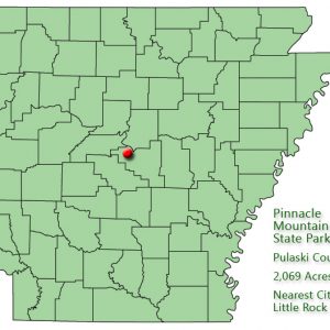
| Location: | Pulaski County |
|---|---|
| Size: | 2,069 acres |
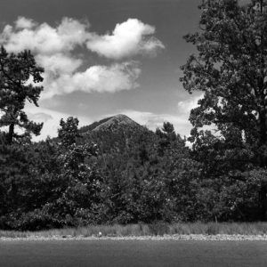
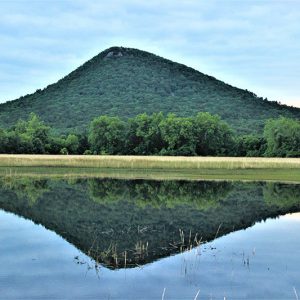
Pinnacle Mountain State Park is located in central Arkansas near the northeast corner of the Ouachita Mountains. The park’s namesake is the first prominent cone-shaped mountain encountered by early westward travelers as they emerged from the alluvial plains of east Arkansas. Its cone-like appearance has long beckoned travelers and residents alike to ascend its peak for breathtaking views of the surrounding hills and valleys.
Rising 756 feet from the adjacent flood plains, Pinnacle’s rocky peak reaches an elevation of 1,011 feet above sea level. The cone-shaped peak was first mentioned in the book A Journal of Travels into the Arkansas Territory During the Year 1819, written by naturalist Thomas Nuttall. During the colonial and early American periods, the mountain was known as “Mamelle” mountain. “Mamelle” is a name commonly applied in the French-speaking parts of the world to a breast or any breast-shaped hill. Over time, the term “Mamelle” became “Maumelle,” which is a name now applied to the Big Maumelle and Little Maumelle rivers, Lake Maumelle, and two different communities in the area.
Pinnacle Mountain, like the rest of the Ouachita Mountains, is part of a highly eroded “crumple zone” that resulted from the collision of two continental plates of the earth’s crust about 275 million years ago. Before the collision process altered the region, the Ouachitas were accumulating sediments on the ocean floor several thousand feet below sea level. Today, after over 275 million years of erosion, the Ouachitas, including many peaks like Pinnacle, are the greatly reduced remains of a once young and mighty mountain range. The remnants of these deep ocean sediments are present today as the gray sandstone and shale found in and around the mountain.
During early European explorations and the colonial period, local Native Americans, from about 1500 to the late 1700s, were the Tunica and the Quapaw. Thomas Nuttall found few Native Americans in the area in 1819. Following the Louisiana Purchase of 1803, the U.S. Government Land Office began selling tracts of future park property. The earliest purchase was in 1826 by Thomas Massengill. During the Indian Removal of the 1830s, several eastern tribes passed within sight of Pinnacle Mountain either by steamboat or on the overland route just north of the Arkansas River.
A trip to “that pinnacle” was a popular activity in the 1800s and the 1900s. Beginning in 1822, the local “Natural Steps” provided a convenient stop for Little Rock (Pulaski County) visitors to disembark for their hike to the mountain. Visitation increased with the construction of the local railroad in the 1890s. With common use of the automobile and improved roads in the early twentieth century, climbing the pinnacle became even more popular and accessible.
Six quarry sites are present within the modern 2,069.3-acre park. Shale and massive sandstones have been removed for a variety of construction projects from about 1920 to the present. The eastern slope of Pinnacle Mountain was a major source of rock used in the construction of the Lake Maumelle dam in the mid-1950s. Modern remnants of the quarried areas are visible as pine thickets, eroded road beds, and bulldozed rock features. Segments of the east summit and base trails follow the old roads.
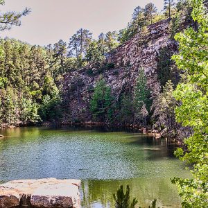
In the area of the original visitor center, north of Pinnacle Valley Road, extensive sandstone quarry operations were conducted in the 1960s to produce rock for the McClellan-Kerr Arkansas River Navigation System. After the land was acquired for a park, the original visitor center and parking areas were built within the old quarry to avoid additional environmental damage. Adjacent to this center is a green water quarry pond with a sheer bluff backdrop of bedded massive gray sandstone and shale. Highly acidic groundwater leaches into the former quarry pit, killing most all aquatic life forms except for blue-green algae, which gives it its characteristic color.
The idea for creating a park focusing on the mountain had been considered for many years but did not get off the ground until the Little Rock Chamber of Commerce adopted a resolution and sent it to Arkansas State Parks. The Fulk family, who owned the largest tract, including Pinnacle Mountain, also supported the plan. In 1971 and 1972, feasibility studies and master plans were commissioned by the Little Rock Chamber of Commerce and the State Parks, Recreation and Travel Commission. The studies and plans were submitted in 1972 to the State Parks, Recreation and Travel Commission, which approved the new park.
The park plan got another boost when, in the fall of 1972, the U.S. Department of Housing and Urban Development (HUD) gave its support to a grant application submitted by the State Parks Division. HUD recognized the need “to preserve such a large tract of land prior to encroachment of either urban development or conflicting commercial/industrial uses….” HUD provided $658,578 for land acquisition, and the Bureau of Outdoor Recreation, a division of the Department of the Interior, contributed $375,000 toward development of the park.
Pinnacle Mountain State Park was approved by the Arkansas General Assembly in 1973 when money was appropriated for its development. In total appropriations, the state matched HUD’s grant with $759,347 for land acquisition (including appraisals, attorney fees, and relocation costs). Development funds from the state to match the Bureau of Outdoor Recreation grant amounted to $429,575.
Twenty-four tracts of land, involving seventeen landowners, were included in assembling the original 1,395 acres comprising the park. The largest portion was acquired from the Fulk estate. Since the park’s creation in the mid-1970s, four additional acquisitions have expanded the park to 2,069 acres.
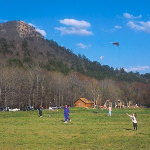
The park provides environmental protection and conservation for a relatively unspoiled tract of hills, forests, and waterways near a growing metropolitan area. It also provides recreational and educational facilities and programs for visitors. The park’s diverse habitats range from high upland rocky peaks, upland forests, and wetlands and bottomlands along the Big and Little Maumelle rivers. The various habitats provide many outdoor recreational and educational opportunities. Included in these are canoe and boat tours led by park interpreters. Also available are educational tours, self-guided trails, wayside outdoor exhibits, four major vistas, and opportunities for natural solitude.
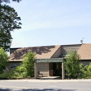
Park facilities include picnic sites, two standard pavilions, two launch ramps, numerous hiking trails, and two overlooks. The first visitor center, overlooking the Arkansas River, opened in 1977 and also marks the starting point of the Ouachita National Recreation Trail, which proceeds 223 miles through the Ouachita Mountains, ending at Talimena State Park in southeastern Oklahoma. The first three miles are within the park. Hiking trails within the park range from the easy one-half-mile paved Kingfisher trail to the two-mile Rocky Valley trail. In 2010, two mountain bike trails were opened in the park. Ten years later, a third was opened. A new park visitor center, which held its grand opening on November 28, 2023, includes interpretative exhibits, a concession stand, bike racks, and more.
In 1991, a gift by International Paper Company Foundation helped establish the Arkansas Arboretum within the park. Located below Pinnacle Mountain and along the Little Maumelle River, the seventy-one-acre site exhibits native flora representing Arkansas’s six major natural divisions. The site includes a 0.6-mile barrier-free interpretive trail, several spur trails in each region, and numerous outdoor exhibits.
Pinnacle Mountain is a day-use-only park with an emphasis on preservation rather than development. Gates at Pinnacle Mountain State Park close one hour after sunset.
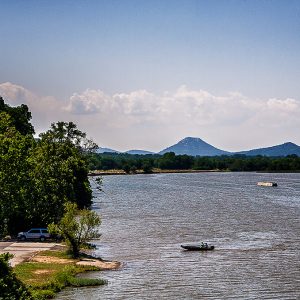
Pinnacle Mountain is bordered on the northwest by 9,000-acre Lake Maumelle in the lower valley of the Big Maumelle River two miles above its confluence with the Arkansas River. A view from the summit affords a panorama of the nearby Ouachita Mountains and expansive valleys of the Arkansas, Big Maumelle, and Little Maumelle rivers.
For additional information:
Arkansas State Parks–Pinnacle Mountain. http://www.arkansasstateparks.com/pinnaclemountain/default.aspx (accessed August 16, 2023).
Ellison, Joan. “Pulaski County State Parks: Pinnacle Mountain Park.” Pulaski County Historical Review 57 (Summer 2009): 64–68.
Nuttall, Thomas. A Journal of Travels into the Arkansas Territory During the Year 1819. Edited by Savoie Lottinville. Fayetteville: University of Arkansas Press, 1999.
James Mullins
Pinnacle Mountain State Park


Comments
No comments on this entry yet.