 Environment
 State Parks Division
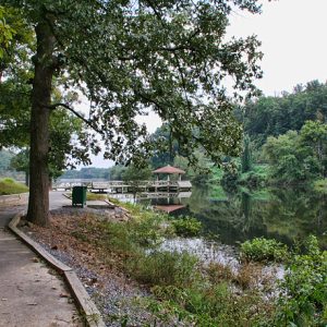 Lake Bennett
 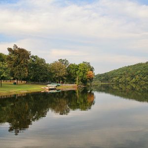 Lake Bennett
 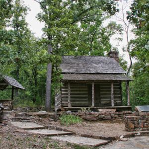 Woolly Cabin
 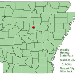 Woolly Hollow State Park: Park Location
 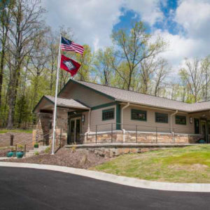 Woolly Hollow Visitors Center
501-918-3025
calsfoundation@cals.org
calsfoundation@cals.org
| Location: | Faulkner County |
| Size: | 370 acres |
Woolly Hollow State Park, located near Greenbrier (Faulkner County), is unique among Arkansas’s fifty-two state parks because it began as the first scientific study in North America of soil and silt erosion with a specific watershed. Originally built in 1935, the lake and the surrounding area opened as a state park on November 2, 1973. The refurbished Woolly Cabin, the homestead of the family after whom the park is named, still stands in the park about three-quarters of a mile from its original location. Woolly Hollow remains one of Arkansas’s most popular state parks and hosts a number of activities for children and adults each year.
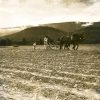
In 1851, William Riley Woolly and his family left Waynesboro, Tennessee, to homestead in Arkansas. In 1882, William Woolly’s Arkansas-born son, Martin, built a sturdy, one-room cabin on the family’s land. The family’s land soon became known as Woolly Hollow. It was in this area that the Works Progress Administration (WPA) and Civilian Conservation Corps (CCC) built a lake dam on land that was acquired by Faulkner County for federal government use from land owners M. M. Shumate and the Missouri Pacific Railroad. After completion in 1935, the area was leased to Faulkner County. The lake was the first project in North America intended to study the effects of water runoff and silt and erosion control from a specific watershed.
As a result of the studies that were carried out under the supervision of Dr. Hugh Bennett, the first director of the U.S. Soil Conservation Service, a new philosophy of land management was born. Practices such as strip cropping, terracing, crop rotation, and scientific planting of vegetation and trees—all commonplace today—were partially developed at Woolly Hollow. Bennett was considered the authority of his time regarding conservation issues, and Arkansas, suffering from widespread erosion and unemployment during the Great Depression, was eager to participate in new federal projects like the WPA and the Soil Conservation Service. Depression-era check dams—staircase-like structures that slow erosion and the deposition of water into the lake—are still visible at the park.
While owned by Faulkner County, the area was known as Centerville Park, as it became a recreational area after the Soil Conservation Service study. However, Faulkner County, seeking to minimize maintenance costs, sold the site to the state. The state drew upon the land’s historical roots when it took possession of the land in 1972 for the creation of Woolly Hollow State Park.
Lake Bennett, with thirty-seven acres of clear water and a sandy beach, is a popular attraction at the park for visitors seeking water recreation, such as fishing or swimming. A visitor’s center, gift shop, snack bar, various camping grounds, picnic sites, boat rentals, and other amenities are provided. Surrounding the lake is another 1935 CCC project. The three-and-a-half-mile Huckleberry Trail begins at the campground bathhouse, follows the perimeter of the lake, and climbs a ridge that offers views of the lake. The trail, which was restored in 1981 by the Youth Conservation Corps, then crosses the earthen dam and weaves its way through a hardwood forest to complete the loop. In June 2014, the ten-mile Enders Fault Mountain Bike Trail was dedicated; it consists of two loops of varying difficulty.
For additional information:
Arkansas State Parks–Woolly Hollow. http://www.arkansasstateparks.com/woollyhollow/ (accessed September 19, 2022).
Clark, Sam. “Origin of Lake Bennett.” Faulkner Facts and Fiddlings 13 (Fall 1971): 67–69.
Staff of the Arkansas Department of Parks and Tourism
Staff of the CALS Encyclopedia of Arkansas


I just want to add to the history of Wooly Hollow. My dad, Ronnie Barton, lived there with his family as a young boy/teenager. Their home was where the pavilion sits on top of the hill near the playground. There are pictures of it around here somewhere. Also he has told me the Woolly Cabin was down the road and was not on the property when they lived there. As you come in from the main drive, the road splits; you can see where an old road years ago continued straight. That was their driveway. My grandfather, Oliver Wendell Barton, had a metal elbow from rolling a tractor down the side of the main drive to the water when the steering failed. It used to be a very narrow road in there.