 Historic Preservation
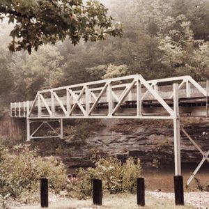 Barkshed Bridge
 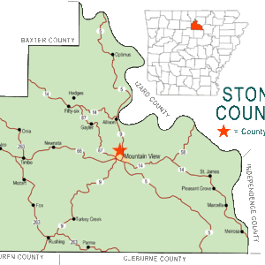 Stone County Map
501-918-3025
calsfoundation@cals.org
calsfoundation@cals.org
Hedges is a historic community located on Gunner Pool Road (Highway 93) about a mile northeast of Fifty-Six (Stone County) and about two miles north-northeast of the recreational area known as Gunner’s Pool, a popular camping, swimming, and fishing site in Stone County. This area is part of the Ozark National Forest.
Native Americans hunted and fished in the Hedges area at least 1,000 years ago, as evidenced by a skeleton discovered in 1955 during the first systematic exploration of the caverns by cavers. The skeleton had a fractured skull, fractured ribs, and a fractured leg. How this explorer entered the cave is unknown. Radiocarbon dating of the remains of a cane and wooden torch indicates that prehistoric human exploration of the cave occurred around AD 215–1155. After ten years of development, the caverns were opened to the public in 1973 as the Dripstone Trail of Blanchard Springs Caverns.
Northwestern Stone County was an isolated wilderness area with abundant game, fish, and edible plants and roots when the first settlers began arriving following the Civil War. The land was heavily wooded with rocky soil, which limited farming activities and allowed for only a few farm animals. The plentiful timber provided for sundry needs such as logs for cabins and other buildings, furniture, tools, barrels, and wagons.
Among the first settlers was James Samuel “Bud” Wallace (or Wallis), whose father came from Lawrence County, Tennessee, to Big Flat (Baxter and Searcy counties) in 1856, the year before Bud was born. The Bud Wallis Hollow is named for him and was noted for its moonshine stills. His home was on North Sylamore Creek in what became the Barkshed Recreational Area.
The Mitchell and Teague families were among Hedges residents who had crops of corn, peas, and cotton. Pines planted by the Civilian Conservation Corps (CCC) stand where the fields were located. The Mitchell mill visible today near what is known as Mitchell’s Bluff is a reconstruction by the CCC of the original mill built by Steve Mitchell in the late 1800s.
The coming of the railroad to Sylamore (Izard County) in 1901 with the extension of the Missouri Pacific on the White River proved a stimulus for the economy of the Hedges area. Sawmills and stave mills, at first relying on water power, sprang up in the region, with a main one at Plum Mill Camp. The mill produced barrel staves and was located on North Sylamore Creek between the mouth of Barkshed Creek and Capp’s Ford Creek. Savage Hamilton Mabry of Kentucky moved his first mill by rail to Sylamore in 1910 and then by the wagons of teamster Aaron Stevens to Capp’s Fork. The timber industry of Hedges continued to flourish through World War II.
On March 6, 1908, President Theodore Roosevelt signed the proclamation creating the Ozark National Forest, the only major hardwood timberland under governmental protection at that time. Operators such as George Cartwright of the Hedges area bought a large amount of timber from the U.S. Forest Service.
Hedges received its name from its first postmistress, Sarah E. Pool “Sallie” Hedges, who was appointed in 1910. The post office was active until 1918. Before the post office, the location was called Northwest on the census reports. Her husband, Fred “Red” Hedges, homesteaded eighty acres on North Sylamore Creek in 1903. Red and Sallie Hedges had journeyed to Arkansas from Illinois in an ox-drawn wagon.
The Capp’s Fork School that had begun in the early 1900s consolidated with Big Flat in the 1930s. In the twenty-first century, the Tri-County Elementary School at Fifty-Six serves the Hedges community with a high school across the county line in Big Flat. A major church for Hedges is the Fifty-Six Missionary Baptist Church.
Hedges is perhaps most famous for being the location of Camp Hedges, a CCC station; part of the New Deal, the CCC provided jobs during the Great Depression in forest and park conservation projects and provided assistance to farms damaged by soil erosion. Camp Hedges served about 2,200 men during its nine years of operation. These men built roads, bridges, and dams as well as trails, shelters, and campgrounds. Much of their work still stands, such as the dam at Gunner Pool.
The popular tourist attraction Blanchard Springs Caverns is located near Hedges, and visitors from all over the world travel the three guided tours. Blanchard Springs was named for John Blanchard, a Confederate Civil War veteran who died in 1914; he owned approximately 160 acres of land, including where the caverns are, and built a gristmill on the land. The mill no longer stands.
The North Sylamore Creek Bridge, a Baltimore deck truss bridge that carries Forest Service Road 1102 over North Sylamore Creek near the Gunner Pool Recreation Area, was built in 1931 and is on the National Register of Historic Places. The bridge is the only known example of this type of truss (a variant of the more-common Pratt truss) in the state.
The few people who live in Hedges today do their shopping in nearby Big Flat, Fifty-Six, and the county seat of Mountain View (Stone County). Tourism is very much a part of the Hedges region, with tourists visiting Blanchard Springs Caverns, the Ozark Folk Center, and Mountain View.
For additional information:
Balentine, Ernestine. “Barkshed.” Big Flat 33rd Annual Homecoming, May 2005.
Bass, Sharon M. W. For the Trees: An Illustrated History of the Ozark-St. Francis National Forests, 1908–1978. Atlanta: U.S. Department of Agriculture, Forest Service, Southern Region, 1981.
Blanchard Springs Caverns, Ozark National Forest. http://www.blanchardsprings.org/ (accessed January 26, 2018).
“Fifty-Six Gets Ready for 1956.” Arkansas Democrat Magazine, January 1, 1956, pp. 7–9.
Fleming, John. The Blanchard Springs Caverns Story. Little Rock: Gallinule Society, 1973.
“Saw Mills—A Way of Life for Stone County Families.” Heritage of Stone 40, no. 1 (2016): 1–64.
“The Timber Industry in Stone County.” Heritage of Stone 39, no. 2 (2015): 1–75.
Kenneth Rorie
Van Buren, Arkansas


Comments
No comments on this entry yet.