 Early Twentieth Century, 1901 through 1940
 Historic Preservation
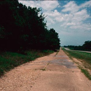 Old Arkansas 51
501-918-3025
calsfoundation@cals.org
calsfoundation@cals.org
Old Arkansas 51 is an abandoned highway located in Clark County between the towns of Curtis and Gum Springs. Constructed in 1931, it was replaced by U.S. Highway 67 in 1965. This stretch of highway was added to the National Register of Historic Places on January 21, 2004.
The communities of Curtis and Gum Springs were settled in the late nineteenth century, and each served as stops on the Missouri Pacific Railroad. The two settlements were connected by roads, which were improved over the decades. The roads evolved from the Southwest Trail, one of the earliest roads in the state.
Named Arkansas Highway 51, the road linking the communities became part of the Arkansas Highway System when it was created in 1923. Some of the state roads became part of the national highway system in 1925, but the preserved portion was not added at that time. From 1925 until 1931, U.S. Highway 67 passed through the towns of Burtsell (Clark County) and Okolona (Clark County) before reaching Arkadelphia (Clark County). Only when the section from Gurdon (Clark County) to Arkadelphia was paved in 1931 was a change made. The old route through Burtsell and Okolona became Arkansas 51, while the newly paved section, including the portion connecting Curtis and Gum Springs, became the new U.S. Highway 67. This switch to the new highway, completed in 1932, was made because it decreased the driving distance between major towns.
The section of the road that was paved at this time measured 14.702 miles in all, broken into two sections. Each section was first improved by grading and adding drainage structures by two contractors; it is unclear which contractor completed the work on the preserved section. The contract to pave the road was given to an Arkadelphia company in January 1931, and the work was completed late that same year. The road remained in service until the newly completed U.S. Highway 67 opened just to the east in 1965.
The road section is about four miles in length and is eighteen feet wide, making each lane nine feet wide. The road was constructed in fifty-foot sections. The section does not include curbs and is constructed of a mixture of tan stone aggregate and concrete. Parts of the section have been repaired over the years. The road is accessible from Highway 67 by using intersections and driveways. The entire road is still drivable, although some sections are overgrown with vegetation. The Old U.S. 67 Rest Area, constructed by the National Youth Administration in 1936 and added to the National Register of Historic Places in 2006, is located along the section.
For additional information:
Arkansas State Highway and Transportation Department. Historical Review: Arkansas State Highway Commission and Arkansas Stare Highway and Transportation Department, 1913–1992. Little Rock: Arkansas State Highway and Transportation Department, 1992.
Hanley, Ray. A Journey through Arkansas: Historic U.S. Highway 67. Charleston, SC: Arcadia Publishing, 1999.
“Old Highway 51.” National Register for Historic Places registration form. On file at Arkansas Historic Preservation Office, Little Rock, Arkansas. Online at http://www.arkansaspreservation.com/National-Register-Listings/PDF/CL0749.nr.pdf (accessed September 17, 2019).
Richter, Wendy, et al. Clark County Arkansas: Past and Present. Arkadelphia, AR: Clark County Historical Association, 1992.
David Sesser
Henderson State University


Comments
No comments on this entry yet.