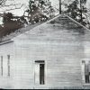
 Carolina Methodist Church
 Historic Preservation
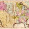 Louisiana Purchase through Early Statehood, 1803 through 1860
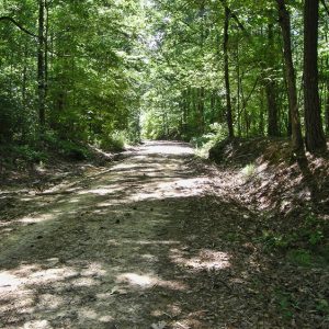 Rosston Segment
501-918-3025
calsfoundation@cals.org
calsfoundation@cals.org
The Camden to Washington Road formerly connected the towns of Camden (Ouachita County) and Washington (Hempstead County). Some sections of the road still exist in the twenty-first century, including a segment near Rosston (Nevada County) that is part of Nevada County Road 10. This portion of the road was added to the National Register of Historic Places on January 29, 2009.
The first effort to create the road began in 1821 when residents of Hempstead County petitioned the Court of Common Pleas to construct a road linking their county with a point on the Ouachita River. This would allow farmers to transport their crops to the nearest navigable river. A map drawn that same year shows a road leaving Ecore Fabre (present-day Camden), running to the northwest in the direction of Washington. Additional work was done around 1828, and the road had several overseers assigned to it, each responsible for the maintenance of a section of the route.
The original route of the road when it crossed into what was then Hempstead County is unclear, but it likely followed the current route of Nevada County Road 10. The road crosses Caney Creek approximately two miles east of Cale (Nevada County). It continues west to intersect Nevada County Road 47 and two and a half miles later intersects with Nevada County Road 46. The segment between these county roads is the section added to the National Register. The road continues to the west and crosses U.S. Highway 371 near Mount Moriah (Nevada County), the first county seat of Nevada County. The road continues to the west, crossing Arkansas Highway 53 near the Sutton (Nevada County) community.
The road was constructed by connecting existing roads with new routes. Feeder routes branched off the road to the north and south, but the Camden to Washington Road served as the major transportation route for the area. It is possible that some members of the Choctaw Nation used the road in the 1830s during Indian Removal. The road also appears on a map created by the Confederate army in 1865, and it was likely used by Confederate forces during the Camden Expedition.
The segment near Rosston was originally in Union County. With the creation of Ouachita County in 1842, the road was in that county until 1871, when Nevada County was created, and the road became part of that county. The area around the segment was never heavily settled, but a number of farms operated nearby in the nineteenth and early twentieth centuries.
The segment is unimproved and consists of sand, gravel, and dirt. It appears much as it did when it was created in the 1820s. Parts of the segment pass between high banks, built up over the decades from use. The road crosses Cypress Creek, forcing visitors to use off-road vehicles due to the rough terrain and often high water. The area around the road is sparsely settled, and most of the agricultural fields that were present in the area have transitioned into timber plantations. Several hunting camps are located along the road, as well as the Carolina Methodist Church.
For additional information:
“Camden to Washington Road, Rosston Segment.” National Register for Historic Places registration form. On file at Arkansas Historic Preservation Office, Little Rock, Arkansas. Online at http://www.arkansaspreservation.com/National-Register-Listings/PDF/NE0164.nr.pdf (accessed November 19, 2020).
David Sesser
Henderson State University


Comments
No comments on this entry yet.