 Map of Peridotite for Diamond Mining
 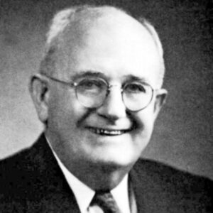 Hugh Miser
 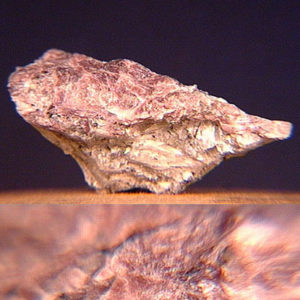 Miserite
501-918-3025
calsfoundation@cals.org
calsfoundation@cals.org
Hugh Dinsmore Miser was a geologist who spent much of his career with the United States Geological Survey (USGS). Over the course of his career, he produced geologic maps of large parts of many states and oversaw investigations of mineral deposits critical to the national World War II efforts.
Hugh Miser was born in Pea Ridge (Benton County) on December 18, 1884. He was the third child of Jordan Stanford Miser, a farmer, and Eliza Caroline Webb. Miser’s ancestors were immigrants of German and English descent who moved from Tennessee to northern Arkansas in the early part of the nineteenth century.
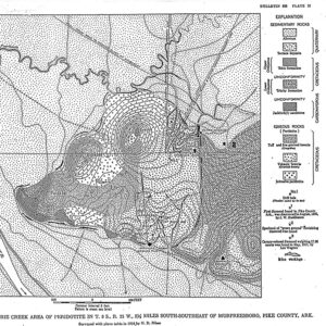
Miser attended the Pea Ridge Normal School, an academy organized by Benjamin Harvey Caldwell. He entered the University of Arkansas (UA) in Fayetteville (Washington County) in 1903, where he attracted the attention of Professor Albert Homer Purdue, who encouraged his study of geology. During the summer of 1907, while still an undergraduate, Miser served as geologic aide to Purdue for a project mapping and interpreting the geology of the De Queen (Sevier County) and Caddo Gap (Montgomery County) quadrangles (areas of land charted by the USGS) in the western Ouachita Mountains of Arkansas. That experience stimulated a consuming interest in Arkansas geology, and started Miser’s life-long career with the USGS.
Miser received a BA in geology from UA in 1908. He continued his employment with the USGS, which promoted him to junior geologist on a full-time basis in 1910 while he was completing his graduate work. Miser was promoted to associate geologist after he received an MA in geology from UA in 1912.
In 1910, Miser married Mary Kate Goddard of Fayetteville, and they had one daughter.
Miser spent almost his entire geological career, from 1912 to 1969, with the USGS. He returned to Fayetteville for the 1919–20 academic year, where he served as both acting professor of geology at UA and acting state geologist while the only geology faculty member, Professor Noah Fields Drake, was on leave in China. In 1926, Miser took a one-year leave of absence to serve as acting state geologist of Tennessee following the resignation of Wilbur Armistead Nelson. He returned to the USGS in 1927.
As an assistant to Purdue, Miser was involved with mapping that resulted in publication of the Eureka Springs (Carroll County) and Harrison (Boone County) quadrangles, the Hot Springs (Garland County) quadrangle, and the De Queen and Caddo Gap quadrangles. In addition, he became an authority on manganese deposits and diamonds in Arkansas. Miser was promoted to the position of geologist in 1919. During the field season of 1921, he participated in a three-month expedition to map the San Juan River in southeastern Utah and describe its hydrology and the geology of the rocks forming its gorge.
In 1923, Miser was assigned the compilation of the first geologic map of Oklahoma. Miser assembled this map from largely confidential materials contributed by major oil companies and independent geologists, and it was published only three years after the project began. In 1928, Miser was appointed chief of the Fuels Branch, the largest entity in the USGS, at age forty-four. In that capacity, he oversaw investigations of strategic and critical minerals during World War II, and governmental support of petroleum exploration and production. The latter effort led to the establishment of the Oil and Gas Preliminary Maps and Charts publication series of the USGS. At his own request, Miser stepped down as chief of the Fuels Branch on July 1, 1947. Following the war, the USGS had cooperative arrangements with some state geological surveys, and Miser was assigned as staff geologist with the Oklahoma Geological Survey from 1948 to 1954 to compile a revision of his state geologic map, which was published in 1954.
Miser retired when he reached the mandatory retirement age of seventy in 1954, but from 1955 until his death, he served as scientific staff assistant in the Office of the Director, USGS in Washington DC. In that capacity, he reviewed and approved maps and reports for publication. Miser was awarded the Distinguished Service Medal by the U.S. Department of the Interior in 1955. He also renewed his association with Arkansas geology by spending one month each year with the Arkansas Geological Commission in Little Rock (Pulaski County), advising its staff on the mapping of the Ouachita Mountains for revision of the Geologic Map of Arkansas.
Miser had eighty-five professional publications during his career. Topics included diamond-bearing peridotites, Ouachita Mountain structure, geology of manganese deposits, mineralogy, and petroleum geology. He was awarded an honorary Doctor of Laws by UA in 1949. In 1950, the mineral “Miserite” was named after him. This unusual cerium-bearing potassium silicate was discovered at the Union Carbide Mine in the Wilson Springs/Potash Sulphur Springs (Garland County).
Miser’s hobby was collecting quartz crystals from Arkansas, and he assembled a large collection of beautiful and unusual specimens. He donated some of these crystals for the manufacture of radio equipment during World War II and presented large collections of crystals to UA and the University of Oklahoma upon his retirement from the USGS.
Miser died at his home in Washington DC on August 1, 1969, of a heart attack.
For additional information:
Cohee, George V. “Memorial of Hugh Dinsmore Miser.” American Mineralogist 55 (March–April 1970): 583–91.
Henbest, L. G. Symposium on the Geology of the Ouachita Mountains. Vol. 1. Little Rock: Arkansas Geological Commission, 1977.
Williams, Nancy A., ed. Arkansas Biography: A Collection of Notable Lives. Fayetteville: University of Arkansas Press, 2000.
Walter Manger
University of Arkansas, Fayetteville
This entry, originally published in Arkansas Biography: A Collection of Notable Lives, appears in the CALS Encyclopedia of Arkansas in an altered form. Arkansas Biography is available from the University of Arkansas Press.


Comments
No comments on this entry yet.