501-918-3025
calsfoundation@cals.org
calsfoundation@cals.org
The Cache River arises near the Arkansas-Missouri border at the confluence of a few agricultural ditches and flows south-southwesterly through Arkansas until it empties into the White River just east of Clarendon (Monroe County). Though it is not a major transportation corridor, the Cache River has nonetheless had an important place in Arkansas history, especially in debates about environmental conservation. The town of Cash (Craighead County) takes its name from the river.
The Cache River was an important water resource for prehistoric Native Americans; for instance, important Indian mound sites connected to the Plum Bayou culture lie within the Cache River floodplain. These early peoples could exploit the variety of natural resources provided by the river and surrounding area, which was home to a variety of animals, including black bears, various species of water fowl, gray and fox squirrels, freshwater mussels, and numerous species of fish. Some sources attribute the origin of the river’s name to the word for “hunt” in the Picardie language, a language closely related to French and one spoken by certain French explorers in Arkansas. The Spanish also encountered the river and wrote about its swamps. With the arrival of American settlers, steamboats began plying the waters of the Cache River, and towns were established in its vicinity. The town of Maberry (Woodruff County), founded on the river in 1842, was a notable shipping point for cotton and locally harvested timber (including several varieties of bottomland hardwood), as was Patterson (Woodruff County). However, the towns established along the White River, which runs nearly parallel to the Cache from Newport (Jackson County) on south, grew larger, given the White River’s greater reach and use as a transportation corridor. The July 7, 1862, Civil War Action at Hill’s Plantation took place near the Cache River in Woodruff County just north of Cotton Plant and ended in a Union victory.
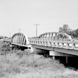
After the Civil War, the lowlands of the Cache River proved a major obstacle for the construction of the Memphis and Little Rock Railroad. In fact, the Federal military government deemed the section between the Cache and the L’Anguille rivers too expensive and difficult to build, and the gap in the line was not completed until 1871. The St. Louis, Iron Mountain and Southern Railroad later constructed a competing line from Bald Knob (White County) to Memphis, Tennessee, that avoided the worst part of the Cache River area. In the late 1870s, before the railroad came to Craighead County, Frank Higginbotham of Jonesboro (Craighead County) ran a keelboat from a channel of the Cache River from O’Kean (Randolph County), where there was an Iron Mountain stop, to a point called Logan’s Ferry, sixteen miles west of Jonesboro. His boat, dubbed “The Good Ship Ranty Doodler,” transported goods until the railroad was run through Jonesboro.
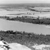
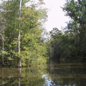
Though the Cache River area was an important source of timber, the area was not as extensively cleared as were other parts of eastern Arkansas due to the river’s reputation for flooding, and major stands of native hardwood survived. Because the Cache moves at a slow speed due to its low amount of fall per mile, and the contour of the flat land surrounding it does not lend itself to levee construction, the Cache River can overflow its banks after only a few inches of rainfall. Work on the river in northeast Arkansas in the 1920s and 1930s straightened the channel of the river, even splitting the river into two separate ditches between Bono (Craighead County) and Egypt (Craighead County), which helped speed the flow of the river, but farming along it was still a risky endeavor. During the Flood of 1937, the Cache River was one of a number of eastern Arkansas rivers that spilled across agricultural land. Planters, landowners, and businessmen long advocated for some form of flood control along the Cache, which had no well-developed system of levees. The Flood Control Act of 1950 authorized the Cache River–Bayou DeView Project, which was a plan to dredge, clear, and realign 140 miles of the Cache upstream from Clarendon, fifteen miles of the upper tributaries, and seventy-seven miles of Bayou DeView, the river’s main tributary. However, initial funds for the project, projected to cost $60 million, were not approved until 1969.
Almost immediately, environmentalists and conservationists protested the project, noting that the Cache River was the site of some of the only remaining wetlands and timberlands in eastern Arkansas, the rest having already been drained and cut over. The Arkansas Game and Fish Commission (AGFC) was the only state agency to object to the project, which had the approval of Congressman Bill Alexander, whose congressional district encompassed the river. Other groups, such as the Environmental Defense Fund, Arkansas Wildlife Federation, Arkansas Duck Hunters Association, Arkansas Ecology Center, along with a few individuals, however, filed suit to stop the project, claiming that the impact statement developed by the U.S. Army Corps of Engineers did not reflect the reality of costs and benefits. On May 5, 1972, Judge J. Smith Henley of the District Court in Little Rock (Pulaski County) ruled in favor of the Corps; the plaintiffs soon appealed the decision. In July 1972, while the project was still under litigation, the Corps, in a controversial move, began the initial clearing and dredging in the Clarendon area. On December 15, 1972, the U.S. Eighth Circuit Court of Appeals in St. Louis, Missouri, remanded the case to Judge Henley, ruling that the Corps had not met the requirements of the National Environmental Policy Act in preparing its environmental impact statement. In March 1973, the court ordered construction halted until the impact statement was revised. Three years later, the statement was finally approved, but the battle over the project had become a political contest, and funding for it was stalemated in Congress in 1977. Opponents of the project moved to creating a national wildlife refuge along the river, partly to block the project but also to protect the river from rampant development then going on, and, in 1986, the Cache River National Wildlife Refuge was established, stretching south from Grubbs (Jackson County) to Clarendon and incorporating a large swath of Bayou DeView.
North of Grubbs, the Cache River exists at present as little more than a ditch or series of ditches. However, the area south of Grubbs is nationally known for preserving bottomland hardwood forest. Aside from the wildlife refuge, the river also hosts the Rex Hancock/Black Swamp Wildlife Management Area and flows just west of the Dagmar Wildlife Management Area. In February 2004, the ivory-billed woodpecker, previously thought extinct, was rediscovered in the Cache River National Wildlife Refuge. In May 2013, the U.S. Army Corps of Engineers and the Nature Conservancy began work on restoring the original route of the Cache River near Clarendon, announcing the completion of the first phase of the project in July 2014.
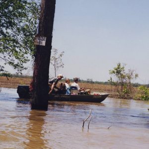
In January 2017, the U.S. Army Corps of Engineers released a new study recommending a variety of stabilization projects to prevent erosion, flooding, and the buildup of sediment. In late January 2024, a levee failure on the Cache River resulted in flash flooding in parts of western Poinsett County and eastern Jackson County.
For additional information:
Atwell, Ameilia K., and Jennifer L. Bouldin. “Effects of Agricultural Intensity on Nutrient and Sediment Contributions within the Cache River Watershed, Arkansas.” Water 14, no. 16 (2022). https://doi.org/10.3390/w14162528 (accessed August 26, 2022).
Brummett, John. “The Cache: It Still Stands as a Symbol of U.S. Dilemma.” Arkansas Gazette. October 30, 1979, pp. 1B–2B.
Miller, Remington. “Cache River Levee Failure Floods Vicinity.” Arkansas Democrat-Gazette, January 30, 2024, pp. 1B, 3B. Online at https://www.arkansasonline.com/news/2024/jan/29/levee-failure-on-cache-river-causes-flash-flooding/ (accessed January 30, 2024).
Shea, William L. “The Confederate Defeat at Cache River.” Arkansas Historical Quarterly 52 (Summer 1993): 129–155.
Shiras, Ginger. “Cache River: Is It a Beauty or a Beast?” Arkansas Gazette. November 14, 1971, p. 10A.
Smith, George. “A History of Cash in Southwestern Craighead County, Part 1.” Craighead County Historical Quarterly 15 (Winter 1977): 12–22.
White, Mel. “Return to the Cache.” Arkansas Times, November 1990, pp. 44–49, 62–64, 66.
Staff of the CALS Encyclopedia of Arkansas


Comments
No comments on this entry yet.