 Bayou Meto, Skirmish at (February 24, 1865)
 Environment
 Hancock, Archibald Rex, Jr.
 Rivers
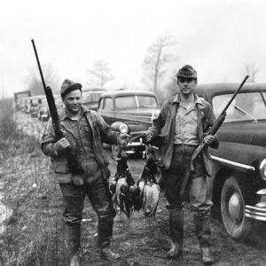 Bayou Meto Duck Hunters
501-918-3025
calsfoundation@cals.org
calsfoundation@cals.org
Bayou Meto is a slow-moving stream that originates in northern Pulaski County at the confluence of several creeks west of Little Rock Air Force Base and travels 150 miles south and east through Lonoke, Arkansas, and Jefferson counties before emptying into the Arkansas River a few miles southwest of Gillett (Arkansas County); it forms parts of the boundary lines between Lonoke and Prairie counties and Arkansas and Jefferson counties. The bayou has lent its name to different communities along its path, a Civil War action in Pulaski County, and the first wildlife management agency (WMA) established by the Arkansas Game and Fish Commission (AGFC).
The origins of the bayou’s name are a matter of debate. Some early French documents dub it “Bayou Metre,” perhaps indicative of a supposed measured depth of one meter, though Judge U. M. Rose put forward the hypothesis that the name is derived from the French mi-terre, or “minor land.” Until the early twentieth century, spelling variants remained common, with “Bayou Metoe” being used with some frequency.
Among the earliest American settlers along Bayou Meto was the Gray family, which settled along the bayou in northern Pulaski County in the early 1820s. The Military Road connecting Memphis, Tennessee, with Little Rock (Pulaski County)—constructed between 1824 and 1826—passed a few miles south of their settlement, which also served as a link between Little Rock and the growing town of Batesville (Independence County) to the northeast. A post office named Bayou Metre was established in 1835, and Bayou Meto Township, encompassing the northern panhandle of Pulaski County, was created in 1840. On August 27, 1863, Confederate troops successfully hindered the advance of Union soldiers upon Little Rock during the day-long Action at Bayou Meto.
The bayou served as a transportation corridor across the Grand Prairie in the territorial and early statehood periods, but the lower portion of the bayou remained largely unsettled until the passage of the Swamplands Act of 1850, which allowed a number of states, Arkansas among them, to claim title to federal land as a means of reclaiming swampland for cultivation. This led to the establishment, especially in the post–Civil War era, of sawmills along the bayou; timber cut along the bayou was floated down to the bayou’s mouth at the Arkansas River, where it was then transported to eastern markets. After the timber boom, cotton was grown and cotton gins were established along the bayou. Though the area remained sparsely settled, it proved popular for hunting and fishing.
In 1923, the U.S. Army Corps of Engineers began work on a floodgate near Bayou Meto’s mouth as a means of keeping floodwaters from pouring into the Arkansas River. This work entailed the construction of a railroad bridge one quarter of a mile north of the bayou mouth for the transportation of materials to the area, and a ditch was dug north of the bayou to divert water from its original channel into the floodgate. Construction was finally completed in 1929, and a bridge was built across the floodgate in 1942 to allow for vehicle traffic between that portion of Arkansas and Jefferson counties; the bridge was part of the original project but had been delayed because the construction company went bankrupt.
In 1948, to accommodate a desire by state residents for more public hunting and fishing land, the AGFC began acquiring land for the establishment of Bayou Meto WMA, which covers 33,832 acres in Arkansas and Jefferson counties. The area has since become known nationwide for duck hunting, and 13,000 acres are flooded each fall to attract waterfowl. Deer hunting is also carried out in the area, and the six lakes in the WMA boundaries provide fishing opportunities, with Cox Cypress Lake and Wrape Lake being stocked annually with channel catfish.
For additional information:
Alford, Julia G. Besancon. “Bayou Meto Township: Pulaski County’s Northern Panhandle, 1818–1910.” Pulaski County Historical Review 39 (Spring 1991): 2–14.
Hightower, Sibyl. “The Village on Bayou Meto.” Grand Prairie Historical Society Bulletin 24 (1981): 30–37.
Little, Carolyn Yancey. “Sampson Gray and the Bayou Meto Settlement, 1820–1836.” Pulaski County Historical Review 32 (Spring 1984): 1–16.
Purvis, George. “Bayou Meto: Big and Wild.” Arkansas Game and Fish 13 (Winter 1981): 8–11.
Staff of the CALS Encyclopedia of Arkansas


The people that lived around Wabbaseka Ark. called Bayou Meto the “Wabbaseka Scatters.”