 Carrollton Road
 Civil Rights and Social Change
 Dover to Clarksville Road
 Harris, Carey Allen
 Point Remove (Conway County)
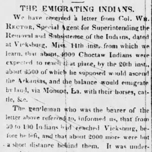 Native American Emigration Story
 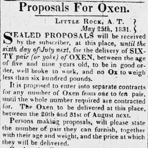 Native American Supplies Ad
 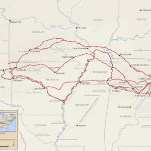 Trail of Tears Map
501-918-3025
calsfoundation@cals.org
calsfoundation@cals.org
The evolving U.S. policy of Indian Removal shaped Arkansas geographically, economically, and ethnically. Federal Native American removal treaties with the Choctaw in 1825 and the Arkansas Cherokee in 1828 established the state’s western boundary. Throughout the territorial period (1819–1836), Arkansas politicians were obsessed with removing Indians from the land within its shrinking borders, even the few destitute Quapaw for whom the state had been named. Yet, a cash-poor frontier economy profited enormously from government contracts when Southeast tribal groups were transported across Arkansas throughout the 1830s, along routes later collectively labeled “the Trail of Tears.” Still, the state’s political leaders complained loudly that the presence of sovereign tribes in neighboring Indian Territory stifled development in Arkansas and, especially after the United States expanded to the Pacific Ocean following the Mexican War (1846–1848), wanted those tribes removed again even further west.
The American policy of removing Indians from tribal lands east of the Mississippi River began to influence the development of Arkansas soon after the Louisiana Purchase. The 1804 act separating Upper Louisiana from the Territory of Orleans authorized the president to exchange land above the thirty-third parallel—the line that became Arkansas’s southern border—with any eastern tribe willing to “remove and settle thereon.” In fact, many refugee bands—notably Cherokee, Choctaw, Delaware, and Shawnee—were already in Arkansas, forced west by questionable land cessions, tribal disputes, harassment, or the search for better hunting grounds. (The Osage, although residing in Missouri, claimed large parts of the state for hunting purposes.) Also scattered around the future state, with more coming, were white squatters, also not waiting for official settlement policies to be decided. For three decades, Arkansas was in flux, awaiting surveys and federal decisions.
Ironically, the first Indian land cessions in Arkansas were obtained to make room for other Indians. President Thomas Jefferson spoke to a Cherokee delegation about “vacant lands” in 1809 when he invited those wishing to move to go to “the country on the waters of the Arkansas and White Rivers.” An 1808 treaty with the Osage had theoretically ceded those lands to the United States. Thousands of Cherokee accepted Jefferson’s invitation and settled in the Arkansas River Valley, infuriating the Osage and provoking years of escalating violence. The U.S. government had hoped that all Cherokee would be lured west. But instead, political friction within the tribe intensified when treaties in 1817 and 1819 forced the developing Cherokee Nation to cede “acre for acre” tribal tracts in the east so that the Arkansas Cherokee could get legal title to the land they occupied.
The Quapaw ceded twenty-eight million acres south of the Arkansas River in 1818 when Missouri Territory Governor William Clark was instructed to acquire more land west of the Mississippi to exchange with eastern Indians.
On February 22, 1819, Spanish and American negotiators finally agreed on the southwest boundary of the Louisiana Purchase. On March 2, the 100th meridian described in the Adams-Onis Transcontinental Treaty became the western boundary of the new Arkansas Territory. It would not be so for long. Although not yet officially named, the western half of the original Arkansas Territory would become Indian Territory.
An 1820 treaty with the Choctaw created an uproar in Arkansas by assigning to that tribe a swath of the new territory between the Arkansas and the Red rivers said to be populated by an estimated 3,000 whites. When few Choctaw were tempted to leave Mississippi, an 1825 treaty moved the Choctaw line farther west, running south from Fort Smith (Sebastian County) and becoming part of Arkansas’s western border, although survey disputes continued until 1886.
Quapaw removal from Arkansas was unique because most of the tribe returned and endured a second removal. In 1824, territorial officials pressured the tribe, which numbered only 455, to give up its remaining two million Arkansas acres and join the Caddo on the Red River in Louisiana. The newcomers were not welcomed, floods destroyed crops, and sixty starved to death. Survivors eventually returned to Arkansas, hoping to be allowed to buy back some of their land and become U.S. citizens. Instead, they were removed to Indian Territory in 1833.
In 1828, after a decade of wrangling over land title and boundaries, a delegation from the Arkansas Cherokee traveled to Washington DC. By establishing the short-lived Lovely County in northwest Arkansas, territorial officials had blocked the outlet to western hunting grounds long promised by the federal government. On behalf of “the Cherokee Nation of Indians, West of the Mississippi,” nine representatives, including the famed Cherokee linguist Sequoyah, agrees to move further west. Still hoping to entice more Cherokee to leave the East, federal negotiators traded about three million acres in Arkansas for seven million acres in what is now northeast Oklahoma, thus establishing the state’s present border north from Fort Smith (Sebastian County). The Western Cherokee become known as the Old Settlers when the Trail of Tears Cherokee arrived in 1839 and eventually established a consolidated tribal government.
The final push for removing all Indians from east of the Mississippi River came with the 1828 election of President Andrew Jackson. Historians write of voluntary Jeffersonian policies and mandatory Jacksonian removal, but the mantra of states’ rights helped force the issue. Beginning with Georgia a month after the election, followed by Alabama and Mississippi in 1829 and Tennessee in 1833, southeastern states began claiming legal jurisdiction over the Indians within their borders, going so far as to outlaw tribal governments. Jackson sided with the states, even when the Supreme Court disagreed. Thus, the Indians had to submit to state jurisdiction to retain their ancestral land or move west to preserve their tribal governments. That leverage, often coupled with unrestrained harassment and fraud, finally convinced many tribal leaders to sign removal treaties. The federal Indian Removal Act of 1830 helped implement the policy of coerced tribal emigrations known in the Southeast as the Trail of Tears. Most states, however, wanted to remove all Indians, not just the tribal governments, and bristled at removal treaties that allowed individual Indians to stay on personal allotments if they agreed to become U.S. citizens. At the time, U.S. citizenship did not guarantee state citizenship or associated civil rights.
In 1830, the Choctaw were the first of the five major Southeast tribes to agree to a removal treaty, emigrating in three official waves in 1831, 1832, and 1833. Fraud involved in Choctaw allotments resulted in the issuance in 1842 of so-called Choctaw Scrip, which speculators could trade to buy land in Arkansas and three other states.
Some Muscogee (Creek) bands began moving west in 1827 after the tribe was forced out of Georgia. Those emigrating after an 1832 treaty ceded Creek land in Alabama were among the most destitute and most numerous traveling through Arkansas. Most had to walk, some in chains as prisoners of war, and their journeys in 1834, 1836, and 1837 were made more miserable by the negligence of private contractors.
After agreeing to a final cession in 1832, the Chickasaw Nation negotiated its own removal in 1837–38, hoping to avoid the problems suffered by earlier emigrants. A small group of Florida Indians signed a removal treaty in 1833, but most resisted emigration, sparking the so-called Second Seminole War (1835–1842), one of the most expensive in U.S. history. Cherokee leaders fought removal in the courts and in Congress, contesting Georgia laws and an unauthorized 1835 treaty. Unable to elude expulsion, the Cherokee Nation organized its own removal in 1838–39. Remnant bands of all these tribes except the Chickasaw remain east of the Mississippi River today.
For Arkansas, the impact included public works and private profit. Federal funds were obtained for improving river navigation, building roads, and establishing a military arsenal. Local newspapers, especially the Arkansas Gazette, regularly touted Indian Removal as an economic opportunity. With the federal bureaucrats in Little Rock (Pulaski County) overseeing emigration subsistence, contracts went to the well connected. Farmers were encouraged to plant corn instead of cotton and provide other supplies and services.
Removal continued past the 1830s in Arkansas as scattered tribal remnants were moved west and elsewhere in the United States as the federal government continued to designate state boundaries surrounding Indian lands. The Osage, for example, who had been moved north to make way for the Cherokee, were forced out of Kansas in the 1870s and back into the future Oklahoma.
Removal from their ancestral lands forever changed these tribes and their cultures. But even greater threats were ahead. By the 1890s, in violation of treaty guarantees and with the help of key Arkansas politicians, tribal lands in Indian Territory would be carved into individual allotments with the aim of terminating tribal governments and preparing the way for Oklahoma statehood in 1907. Yet, despite the efforts to destroy them, the tribes survive, and as federal policy continues to evolve, some even thrive. For individual Indians, now accepted as Native American, they have legal status as dual citizens of their tribe and of the United States.
For additional information:
Abel, Annie Heloise “The History of Events Resulting in Indian Consolidation West of the Mississippi.” In Annual Report of the American Historical Association for the Year 1906. Vol. 1. Washington DC: American Historical Association, 1908.
Berry, Cody Lynn. “Early Arkansas Banking and Indian Removal, 1819–1860.” MA thesis, University of Arkansas at Little Rock, 2016.
Bolton, S. Charles. Arkansas, 1800–1860: Remote and Restless. Fayetteville: University of Arkansas Press, 1998.
Cash, Jon D. “Removal of the Quapaw and Osage.” Arkansas Review: A Journal of Delta Studies 48 (December 2017): 163–179.
Garrison, Tim Alan. The Legal Ideology of Removal: The Southern Judiciary and the Sovereignty of Native American Nations. Athens: University of Georgia Press, 2002.
———. “On the Trail of Tears: Daniel Butrick’s Record of the Removal of the Cherokees.” In Removing Peoples: Forced Removal in the Modern World, edited by Richard Bessel and Claudia B. Haake. Studies of the German Historical Institute London. New York: Oxford University Press, 2009.
Hanson, Gerald T., and Carl H. Moneyhon. Historical Atlas of Arkansas. Norman: University of Oklahoma Press, 1989.
Haveman, Christopher D. Rivers of Sand: Creek Indian Emigration, Relocation, and Ethnic Cleansing in the American South. Lincoln: University of Nebraska Press, 2016.
Journey of Survival: Indian Removal through Arkansas. http://www.journeyofsurvival.org/ (accessed April 9, 2024).
Key, Joseph Patrick. “‘Outcasts upon the World’: The Louisiana Purchase and the Quapaws.” Arkansas Historical Quarterly 62 (Autumn 2003): 272–288.
Paige, Amanda L., Fuller L. Bumpers, and Daniel F. Littlefield Jr. Chickasaw Removal. Ada, OK: Chickasaw Press, 2010.
Reynolds, John Hugh. “The Western Boundary of Arkansas.” In Publications of the Arkansas Historical Association. Vol. 2. Little Rock: Arkansas Historical Association, 1908.
Sequoyah National Research Center. University of Arkansas at Little Rock. https://ualr.edu/sequoyah/ (accessed April 9, 2024).
Williams, Patrick G., ed. A Whole Country in Commotion: The Louisiana Purchase and the American Southwest. Fayetteville: University of Arkansas Press, 2005.
Wright, Muriel H. A Guide to the Indian Tribes of Oklahoma. Norman: University of Oklahoma Press, 1951.
Kitty Sloan
Arkansas chapter, Trail of Tears Association


Comments
No comments on this entry yet.