 Environment
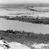 Geography and Geology
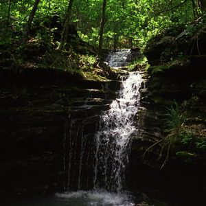 Big Piney Creek Waterfall
 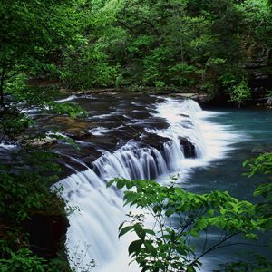 Richland Creek
 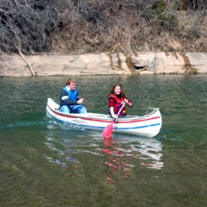 Sylamore Creek
501-918-3025
calsfoundation@cals.org
calsfoundation@cals.org
Designation of rivers as a method of protection grew out of the environmental movement of the late 1960s and early 1970s. In discussions of designation, the terms “river” and “stream” are used interchangeably. At the national level, the Wild and Scenic Rivers Act of 1968 was landmark in recognizing that certain rivers have value and should be preserved in their free-flowing condition. This legislation served as a model for state initiatives. The federal and state models for designation concentrated on activities in the principal channel of the river, such as damming and dredging. At the time, these activities were the biggest threats to rivers. Issues such as gravel mining, minimum stream flow requirements, and property rights activism had not yet developed.
The state legislature created the Arkansas Natural and Scenic Rivers Commission in 1979. The enabling legislation reads in part: “Certain rivers in the State of Arkansas possess outstanding natural, scenic, educational, geological, recreational, historical, fish and wildlife, scientific, and cultural values of great present and future benefit to the people. A balance [shall] be established between the alterations by man and the protection of natural beauty along these rivers.” The legislation also created the Arkansas Natural and Scenic Rivers System, which allowed the legislature to designate rivers for protection from dredging and damming.
In 1997, the legislature dissolved the commission and moved the responsibilities of the Arkansas Natural and Scenic Rivers System to the Arkansas Natural Heritage Commission, part of the Department of Arkansas Heritage. With the responsibilities for the state scenic rivers system, the Arkansas Natural Heritage Commission is a resource and contact point for state and federal river designation information.
Arkansas Natural and Scenic Rivers System
Arkansas Natural and Scenic Rivers System designation requires action of the General Assembly based on review and recommendations of local governments and citizens from the area through which the river flows. Rivers are classified as natural, scenic, or pastoral. The criteria involve the stream’s length, adjacent forest cover, biological characteristics, water quality, present use, and accessibility. A river or river segment listed in the system is protected from any permanent dam or structure that would impound waters or any channelization or realignment of the principal channel of the stream. Rivers listed in the Arkansas Natural and Scenic Rivers System include:
· Cossatot—Twenty-six miles, from the north end of Gillham Reservoir upstream to headwaters near Baker Mountain in Polk and Howard counties of western Arkansas.
· Strawberry—Forty-three miles, from the line dividing Sharp and Izard counties upstream to headwaters near Byron in the north central part of the state.
· Saline—157 miles, from confluence with the Ouachita River in southern Arkansas, near Union County and the Louisiana border, upstream to the Grant/Saline County line in central Arkansas.
· Little Missouri—Twenty-nine miles, from the upper end of Lake Greeson upstream to headwaters south of Big Fork in Polk, Montgomery, and Pike counties in western Arkansas.
Designation in the Arkansas Natural and Scenic Rivers System is not related to the Extraordinary Resource Water designation; this is a separate water quality designation administered by the Arkansas Department of Environmental Quality and related to the Clean Water Act.
Federal Wild and Scenic River Designation
Congress created the National Wild and Scenic Rivers System in 1968 to preserve rivers with outstanding natural, cultural, or recreational features in free-flowing conditions. Rivers may be designated by Congress (usually after a study by a federal agency) or the secretary of the interior. Each river is administered by a federal or a state agency. The river designation might not include the entire river but may include tributaries. For federally administered rivers, the designated boundaries usually average about one-quarter mile on each side of the river to protect related natural, cultural, and recreational values.
Each designated river is administered with the goal of nondegradation and enhancement of the values that caused it to be designated. Other uses, including recreation, a variety of agricultural practices, and residential development, may continue. In most cases, not all land within the boundaries is or will be publicly owned. In fact, where there is a federal administering agency, there are limits on how much land the agency is allowed to acquire.
The Federal Energy Regulatory Commission is prohibited from licensing projects on or directly affecting designated rivers. Other federal agencies cannot assist by loan, grant, license, or otherwise in the construction of any water resources project (such as dams, water diversion, channelization, and riprapping) that would have a direct and adverse effect on river values.
In 1992, eight streams in Arkansas were designated as components of the National Wild and Scenic Rivers System. Six are in the Ozark/St. Francis National Forest, which serves as the federal administering agency. Two are in the Ouachita National Forest, the federal administering agency. Part of the Cossatot River is managed by the state through the Cossatot River State Park/Natural Area.
The Nationwide Rivers Inventory (NRI) is a list of more than 3,400 free-flowing river segments in the United States that are believed to possess one or more “outstandingly remarkable” natural or cultural values judged to be of more than local or regional significance. Under a 1979 presidential directive and related Council on Environmental Quality procedures, all federal agencies must seek to avoid or mitigate actions that would adversely affect one or more Nationwide Rivers Inventory segments. The inventory is a source of information for statewide river assessments and federal agencies involved with stream-related projects. Arkansas has forty-two streams or stream segments listed in the NRI.
|
National Wild and Scenic Rivers |
|||||
| River | Administering Agency |
Miles by Classification |
|||
|
Wild |
Scenic |
Recreational |
Total |
||
| Big Piney Creek | Forest Services |
– |
45.2 |
– |
45.2 |
| Buffalo | Forest Services |
9.4 |
6.4 |
– |
15.8 |
| Cossatot | Forest Services |
– |
11.3 |
4.2 |
15.5 |
| Army Corps of Engineers |
– |
4.6 |
|
4.6 |
|
| State of Arkansas |
|
10.7 |
|
10.7 |
|
| Hurricane Creek | Forest Services |
2.4 |
13.1 |
– |
15.5 |
| Little Missouri | Forest Services |
4.4 |
11.3 |
– |
15.7 |
| Mulberry | Forest Services |
– |
19.4 |
36.6 |
56.0 |
| North Sylamore Creek | Forest Services |
– |
14.5 |
– |
14.5 |
| Richland Creek | Forest Services |
5.3 |
11.2 |
– |
16.5 |
For additional information:
American Rivers. http://www.americanrivers.org (accessed April 1, 2024).
National Wild and Scenic Rivers System. http://www.nps.gov/rivers/index.html (accessed April 1, 2024).
Arkansas Natural Heritage Commission
Little Rock, Arkansas


Comments
No comments on this entry yet.