 Bridges
 Environment
 River Designations
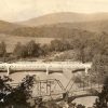
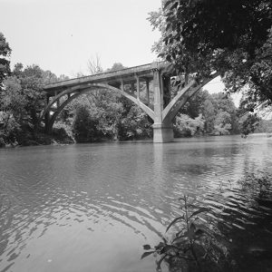 Benton Bridge
  Jenkins' Ferry State Park
 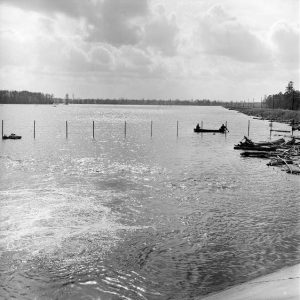 Lake Georgia Pacific
 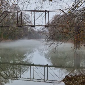 Old River Bridge
  Saline River
 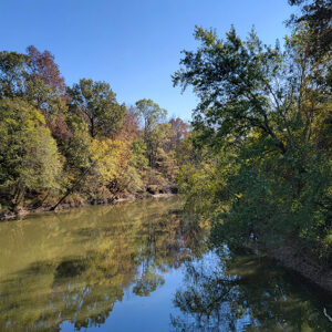 Saline River
 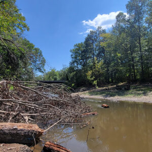 Saline River at Jenkins Ferry
 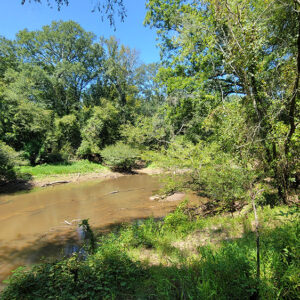 Saline River at Jenkins Ferry
 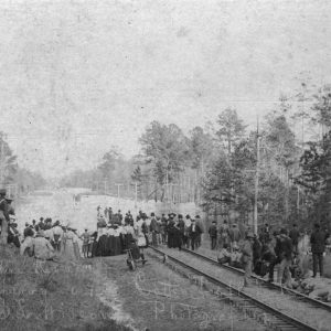 Saline River Flood
 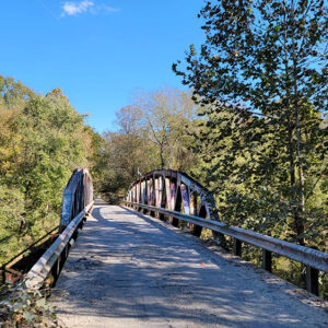 Shaw Bridge
 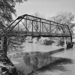 Tull Bridge
501-918-3025
calsfoundation@cals.org
calsfoundation@cals.org
The Saline River is known throughout the South for its scenic beauty and its unique characteristic of being a mountain stream at its origin in the Ouachita Mountains and a Delta-type bayou near its mouth at Felsenthal (Union County), where the stream converges with the Ouachita River. It is the last free-flowing river in the Ouachita basin. The river derived its name from a salty marsh located near its mouth, called by the French the “Marias Saline,” though some historians claim that a salt works started near Benton (Saline County) as early as 1827 gave the river its name. At one time, these salt works supplied the bulk of salt used in the territory as well as surrounding states. Although the northern section of the river was popular for its salt works, the southern section was known for its large fields of lignite. Exposures of lignite were found in many areas of the river, but the largest area was in Bradley County at Goulett Island. In 1860, Governor Elias N. Conway owned this area along the river.
The Saline rises north of Benton in the Ouachita Mountains and is formed by four forks that converge near Riverside in Saline County. The South Fork is thirty-eight miles long and is the only one not wholly formed in Saline County. The Middle Fork is thirty-seven miles long, and its banks are a paradise of wildflowers. Alum Fork is sixty-one miles long and is a dramatic stream, flowing at the base of towering cliffs. North Fork is the shortest at twenty-nine miles. The Saline meanders through Saline, Grant, Dallas, Cleveland, Bradley, Drew, and Ashley counties before it empties into the Ouachita River. Among the communities located near the river are Haskell (Saline County), Traskwood (Saline County), Prattsville (Grant County), Farindale (Dallas County), Staves (Cleveland County), Rison (Cleveland County), Warren (Bradley County), and Longview (Ashley County).
This 204-mile stream has been called Merry Saline, Saline Bayou, Marie Saline, Marais Saline, and Marais de Saline. The watershed consists of about 3,350 square miles. Its bottom is gravel with an abundance of aquatic insects and other organisms. It includes a series of pools and fast-running shoals that contain many species of fish.
When the Native Americans gave up their land in an 1818 treaty, they left reminders of their 300-year sojourn. Although historical tradition states that the upper region of the Saline is closely associated with Quapaw Indians, excavated relics, artifacts, and pottery are of Caddoan origin. The Hughes mound, located near Benton, is one of the largest Indian mounds along the river.
The southern part of the river is rich with French history. In the late 1700s, many French families settled along the banks of the lower Saline. Among the early French settlers were the Fogle, LaBeouff, DuBose, Charron, Pevetoe, Ramsauer, De Ambleton, Carcuff, and Bullet families. Several of the place names along the river derived from the French.
During steamboat days, the head of navigation was at Bridges Bluff in Cleveland County. Cotton, staves, and timber were shipped down river each winter and spring to New Orleans and Monroe, Louisiana. Fifty-four steamboats have been documented on the Saline. Among the captains were Bob Withers, Len Moore, John Wesley Smith, and Frank Keeling. The Hampton brothers and John N. Wheeler were primary shippers until the early 1900s, when the Slavonians migrated to the area and became instrumental in cutting and shipping staves. Among the Slavonians were the Lipovac, Karlovic, Kusterin, Dorich, and Piskulick families. Shipping on the river slacked off considerably with the advent of the rail system in 1880. One of the last steamboats up the Saline was the Gate City, which sank on October 14, 1913, near Warren.
Although there were no major Civil War battles along the Saline, minor battles, skirmishes, and engagements occurred at Jenkins’ Ferry in Grant County, Mount Elba and Marks’ Mills in Cleveland County, and Longview in Ashley County.
The Flood Control Act of 1937 proposed that every major stream in the Ouachita Basin be dammed. Numerous studies were made by the Corps of Engineers, and the initial plan included an earthen dam capable of generating hydroelectric power and offering water recreation as a factor for justification. The plan was rejected in Washington DC when authorities were alerted that Arkansas state law prevented contact sports in lakes generating electric power. By this time, opposition to the dam peaked. Elected officials in several counties opposed the structure, while only minimal support surfaced for the project. The only support for the dam seemed to be a select few Benton residents. In 1973, Governor Dale Bumpers asked the Corps of Engineers to restudy the feasibility of the dam because of the long-range need for water in central Arkansas. When the Little Rock Water Department stated that the city did not need any of the water generated from a new dam, the demise of the proposed project was assured. The enduring fight for Saline’s survival as a free-flowing stream was not easy, and its outcome was not actually realized until February 1975, when Governor David Pryor decided against the project.
In the 1890s, pearl fishing became fashionable after a pearl was found in a mussel shell near Benton by Jim Davidson and was considered the largest specimen of its kind. Prices for freshwater pearls ranged from $30 to $250. Pearl fishing was a very popular sport in all sections of the river. One of the most proficient pearl hunters in the state was Professor J. H. Hinemon, who taught at the Agricultural College in Monticello (Drew County), now the University of Arkansas at Monticello (UAM).
In August 1999, Charles Green found an ancient Indian dugout at Peeler Bend near Benton. Archaeologists dated the twenty-four-foot canoe to the 1100s. It is tooled in the fashion of the Caddo Indians. The canoe was housed at the Historic Arkansas Museum in Little Rock (Pulaski County) until 2017, when it was loaned to the City of Benton.
Although commerce diminished on the river by the 1930s, the Saline remains relatively unspoiled. In the twenty-first century, its entire length is used mostly for fishing and recreation.
For additional information:
Dunnahoo, Patrick. Of Clear, Cool Water and Gentle Hills: The Story of the Four Forks of Arkansas’ Saline River. Benton, AR: 1993.
Moseley, Ron. Ghosts of the Saline River: Secrets behind the Fascinating River and Its Past. N.p.: 2015.
Owen, David Dale, et al. Second Report of a Geological Reconnaissance of the Middle and Southern Counties of Arkansas, Made during the Years 1859 and 1860. Philadelphia: C. Sherman, 1860.
Jann Woodard
Benton, Arkansas


My mother and siblings used to play on the banks of the Saline as children in the 1930s. Their parents would not let them get in the water, as it was polluted from chemicals from a factory upstream. She said the river was lifeless.