 Womble District Administration House Number 1
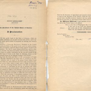 Arkansas National Forest Proclamation
 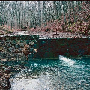 Crystal Springs Dam and Camp Shelter
 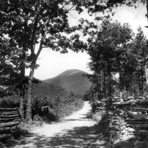 Eagle Mountain
 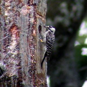 Red-cockaded Woodpecker
 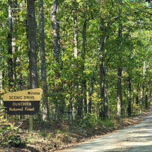 Winona Scenic Drive
501-918-3025
calsfoundation@cals.org
calsfoundation@cals.org
The Ouachita National Forest, originally called the Arkansas National Forest, was created through an executive order issued by President Theodore Roosevelt on December 18, 1907. Forest Service Chief Gifford Pinchot remarked at the time that this national forest was the only major shortleaf pine forest under the federal government’s protection. In January 1908, the Arkansas Sentinel newspaper reprinted an article from Forestry and Irrigation Magazine that praised the hearty spirit of cooperation manifested by Arkansas’s people and spoke of benefits to be gained by the conservation of timber supplies.
At first, the Arkansas National Forest consisted solely of reserved public domain lands (part of the Louisiana Purchase) south of the Arkansas River. The 1911 Weeks Law, which authorized federal purchase of forest lands in the eastern part of the United States, was later used to add thousands of acres of cutover or farmed out lands to the national forest. The largest increases in national forest ownership occurred from 1933 to 1941.
On April 29, 1926, President Calvin Coolidge changed the name of the Arkansas National Forest to the Ouachita National Forest. He also proposed extending the national forest into eastern Oklahoma. President Herbert Hoover fulfilled this proposal on December 3, 1930, by extending the Ouachita National Forest into Le Flore County, Oklahoma.
Today, the Ouachita National Forest consists of nearly 1.8 million acres located in twelve Arkansas counties and two Oklahoma counties. It is the largest and oldest national forest in the southern region of the United States. The forest includes sixty developed recreation areas, six wilderness areas, two national wild and scenic rivers, 700 miles of trails, several scenic byways, many special interest (botanical and scenic) areas, abundant historic and prehistoric resources, and habitat for eleven federally listed—and hundreds of other—plant and animal species. It also provides timber and other forest products to the nation, offers diverse hunting and fishing opportunities, and is the source of high-quality drinking water for hundreds of thousands of people in Arkansas and Oklahoma.
The Ouachita National Forest is divided into five ranger district (RD) clusters: Caddo-Womble RD with offices located in Glenwood (Pike County) and Mount Ida (Montgomery County); Jessieville-Winona-Fourche RD with offices in Jessieville (Garland County), Perryville (Perry County), and Danville (Yell County); Poteau-Cold Springs RD with offices in Waldron (Scott County) and Booneville (Logan County); Mena-Oden RD with offices located in Mena (Polk County) and Oden (Montgomery County), and Oklahoma RD with offices located in Talihina, Hodgen, and Idabel, Oklahoma.
For additional information:
Nelson, Rex. “Rugged Terrain.” Arkansas Democrat-Gazette, January 29, 2023, pp. 1H. 6H. Online at https://www.arkansasonline.com/news/2023/jan/29/rugged-terrain/ (accessed January 30, 2023).
Ouachita National Forest. USDA Forest Service. http://www.fs.usda.gov/ouachita (accessed November 19, 2020).
Debbie Ugbade
Ouachita National Forest


Comments
No comments on this entry yet.