 Geography and Geology
 Silver Mining at Kelloggs Creek Article
501-918-3025
calsfoundation@cals.org
calsfoundation@cals.org
The silver in Arkansas is mixed sulfide ores of lead, zinc, copper, and antimony in small, scattered deposits in parts of the southern and eastern Ouachita Mountains. Most of the known mining activity involving silver took place between 1840 and 1927 and rarely resulted in profit to owners and operators. Sale of claims or mines to unsuspecting investors was usually the only route to profit. The mines opened in the 1800s were shallow, reaching maximum depths of less than 200 feet.
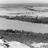
Most of the deposits where mining was undertaken are clustered in three groups. One is along Kellogg Creek in Pulaski County, north of the Arkansas River. Deposits in another group were clustered along tributaries near the confluence of the north and south forks of the Ouachita River in Montgomery County. The third occurs along both the Rolling Fork of the Little River and along the Cossatot River in northern Sevier and Howard counties. In the 1848–49 period, ores from the Kellogg mine were shipped down the Arkansas and Mississippi rivers to the port of New Orleans and then to Wales (United Kingdom) for recovery of the silver. The Rolling Fork, Cossatot, and Ouachita rivers were not navigable.
Newspapers are almost the only source for numbers relating to mine output. Phrases such as, “Much valuable ore was raised,” could be seen in the news, but specific numbers were rarely mentioned. Requirement for disclosure of production figures to the government came late (1922) in the period that silver was mined in Arkansas, and those who did the mining seldom kept thorough records. Published assays of samples confirmed the presence of silver in ores from mines in all three of the groups described. Most samples sent for assay were selected ore mineral specimens, usually much richer than the ore the miners could deliver.
The geologic conditions in the Kellogg area have been described at various times, most recently and thoroughly in 1977 by the Arkansas Geology Commission. Early state geologist David Dale Owen examined the site in 1857 and was impressed with what he could see, but the shafts were inaccessible because of water and decay. Using material from waste piles, he reported assays showing silver values of 339 and 224 ounces per ton.
The original Kellogg mine was opened in 1840 south of Kellogg Creek by the South Western and Arkansas Mining Company, under a lease from Benjamin Kellogg. It was followed by several other mines on both sides of the creek; they all ceased operations before 1852. Operations in this period yielded up to 500 tons of lead-silver concentrate, valued at $90 to $100 per ton, all of which was shipped for processing to Liverpool, England.
There was no more activity until the Confederate government began mining the Kellogg properties in 1861, in support of Civil War action. In mid-September 1863, Union forces took the area and destroyed the mine installations. In 1866, there began a succession of unproductive operations near the earlier mines. None lasted more than a year or two, and the properties were idle after 1893. The final operation began in 1923 with a lease from the estate of former Arkansas governor and U.S. senator James P. Clarke. Extensive underground workings reached a maximum depth of 1,100 feet until the mine closed in 1926. The four-year operation reportedly produced seventy tons of lead-silver concentrate, containing 3,100 ounces of silver, and thirty tons of zinc concentrate, a result far outweighed by the cost of mining and preparing the concentrates.
In eastern Montgomery County, prospecting and mining for lead and silver began before 1840 on a small scale in the Gap Creek area east of the crossroad that would, after 1876, become Silver City. Beginning in about 1874–75, word of the silver had begun to spread, and miners displaced from western districts, particularly from Colorado and California, began to trickle into Arkansas. The pace quickened some after 1878, and by 1880, Silver City was said to have had a population of more than 1,000. By the end of 1882, all the mines had closed; the boom had faded.
Out of the hundreds of claims and prospects within a few miles of Silver City that were worked during the boom years, about three dozen produced ore for the market and were followed in the news of the day. The most prominent of these mines was the Minnesota, owned by Joseph “Diamond Jo” Reynolds, the riverboat magnate and builder of the Hot Springs Railroad. Another mine was the Walnut, owned and operated by “Joplin Lead King” Elliott R. Moffet, wealthy Joplin, Missouri, smelter owner and first mayor of that city (1873). Moffet returned from Joplin in 1886 to take part in the Action at Bear City.
There was a brief resurgence of mining around Silver City in 1888 in response to the gold rush at nearby Bear (Garland County), after which Silver City activity settled back to the pre-boom small fashion into the early 1900s. The Bear City gold rush was propagated by crooked assayers; the hills were later found to be barren of gold and silver. This widely publicized fraud may have hindered Arkansas’s industrial development for decades.
Antimony was the only commercial product on official record from the third cluster. Silver was present near the surface in ores mostly of lead, zinc, and antimony. The silver prompted early interest, and some was said to have been recovered, but there is no record beyond a few assays that showed ten to sixty-five ounces of silver per ton. After the mid-1870s, when the focus turned to mining for antimony, silver ceased to be of interest. Lead was produced from several mines beginning in the 1840s, particularly the Davis and Bellah mines in Sevier County. The U.S. Army Corps of Engineers has maintained the Bellah mine property as a park on the shore of De Queen Lake.
For additional information:
Comstock, T. B. “Geology of Western Central Arkansas.” In Arkansas Geological Survey An. Rept. For 1888, edited by John C. Branner. Vol. 1, Gold and Silver. Little Rock: Office of the Geological Survey of Arkansas, 1891.
Conrad, C. P. “Silver in Arkansas.” Engineering & Mining Journal 30 (September 11, 18, 25, 1880): 172, 186–187, 203–204.
Konig, Ronald H., and Charles G. Stone. “Geology of Abandoned Kellogg Lead-Zinc-Silver-Copper Mines, Pulaski County, Arkansas.” In Symposium on the Geology of the Ouachita Mountains, edited by Charles G. Stone. Vol. 2, Economic Geology, Mineralogy and Miscellaneous. Little Rock: Arkansas Geological Commission, 1977.
Miser, Hugh D., and A. H. Purdue. Geology of the De Queen and Caddo Gap Quadrangles, Arkansas. U.S. Geological Survey Bulletin 808. Washington DC: Government Printing Office, 1929.
Owen, David Dale. First Report of a Geological Reconnoissance [sic] of the Northern Counties of Arkansas, Made During the years 1857 and 1858. Little Rock: Johnson & Yerkes, State Printers, 1858.
Leonard M. Sherman
Little Rock, Arkansas


Comments
No comments on this entry yet.