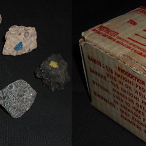
 AGC Mineral Set
 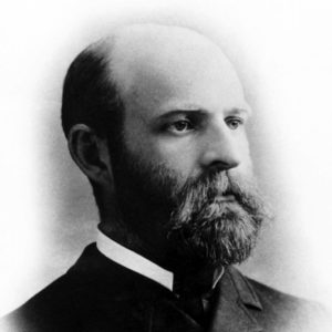 John Casper Branner
501-918-3025
calsfoundation@cals.org
calsfoundation@cals.org
The Arkansas Geological Survey (AGS), formerly the Arkansas Geological Commission (AGC), is a division of the Arkansas Department of Energy and Environment (ADEE) charged with the investigation of the geology, geologic processes, and geologic resources of the state. It is further charged to encourage the effective management and utilization of the various mineral, fossil-fuel, and water resources with proper consideration of the potential environmental impacts of that activity.
The Geological Survey of Arkansas was first established in 1857 with engagement of David Dale Owen as state geologist. He was funded for three years and was only able to publish part of his findings. Owen ultimately published another report in 1860 just a few days before he died. His training in geology was such that he assumed a potential for significant mineral possibilities in the state, including precious metals that did not truly exist.
In the years following the Civil War, the suggestion of precious metals grew into many promotional operations. In order to look into these assertions, the Geological Survey of Arkansas was revived in 1887 with John C. Branner as state geologist. Branner hired a staff of excellent geologists, many of whom later moved on and became nationally famous. Branner even had Herbert Hoover working for him as a student assistant. Branner’s team of geologists quickly discovered that the various precious metal mining promotions were without merit and advertised the fact. The incensed operators and investors demanded Branner’s head—he was even hanged in effigy in the streets of Little Rock (Pulaski County)—and an end to the survey. Although the survey’s funding was terminated in 1893, the legislature did continue to provide funds for publication of the work of Branner’s geologists.
The Geological Survey of Arkansas was reconstituted in 1923 under George Branner, the son of John C. Branner. George Branner was not a geologist, had little funding, and accomplished little during his tenure. Richard J. Anderson and Joe Kimzey succeeded George Branner during the early part of World War II (1942–1943). With the end of the war, Harold Foxhall was appointed state geologist and started rebuilding the survey. In 1951, Norman F. Williams was appointed state geologist and guided the survey for the next forty-four years, during which time the agency completed a reconnaissance geologic map of the state and published many documents on its geology, mineral resources, fossils, and water. William V. Bush, Mac Woodward, and Bekki White in turn succeeded Bill Williams as state geologist in the following years. The predecessor to the present agency was created as the Arkansas Geological Commission by Act 16 of 1963. Act 129 of 2007 changed the agency’s name to the Arkansas Geological Survey, and Act 910 of 2019 placed the agency under the newly created Arkansas Department of Energy and Environment (ADEE).
The AGS is a scientific research organization and does not have any direct regulatory functions. The state geologist, by law, serves on several state boards, commissions, and task forces such as the Arkansas Pollution Control and Ecology Commission (APCEC), which establishes the rules and regulations for the Arkansas Division of Environmental Quality (ADEQ) and the Individual Sewage Disposal Systems Advisory Committee (ISDSAC). Various staff members are advisors to some regulatory agencies and special-purpose groups charged with safeguarding the public’s welfare. These efforts include reviewing mining and reclamation plans, reviewing landfill permits, and giving geotechnical counsel. Staff members regularly provide technical assistance on earthquake, water quality, environmental, mapping, professional, GIS, and waste issues.
Much of the work of the AGS is directed toward assisting the general public in everyday problems and inquiries. The fossil fuels section of the AGS conducts research on both conventional and unconventional natural gas plays within the state as well as oil potentials and coal resources. The AGS provides information and assistance with respect to metallic and non-metallic mineral resources. Staff geologists reply to requests relating to source, quality, and quantity of water supplies for home, municipal, water-district, and agricultural uses. The survey also maintains cooperative programs with the U.S. Geological Survey’s Water-Resources Division (USGS-WRD) and is involved in the collection and publication of data on stream discharge and stage, reservoir and lake storage, ground-water levels for major aquifers, and the physical and chemical quality of both surface and ground water.
Geological mapping is a tool for decision makers who have a need to understand the nature, composition, and distribution of earth materials, and hence, the AGS has a team of geologists conducting geologic mapping as an ongoing activity. Approximately three 7.5-minute quadrangles are mapped each year. These maps are compiled as digital products.
Geologic hazards in Arkansas include, but are not limited to, landslides, earthquakes, karst terrain issues, shrinking and swelling soils, and naturally occurring contaminants such as mercury and radon. The geohazards section of the AGS has ongoing projects in the areas of earthquakes, landslides, and karst issues and has investigated mercury and soil questions in the past.
As a part of its community outreach, the staff of the AGS presents “show-and-tell” talks and field trips to organizations including professional groups, university classes, natural-history groups, recreational groups, school groups, church groups, and interested ad hoc assemblages. The AGS has a program to develop geologic maps and guidebooks for state parks, national parks, national forests, and other areas of public interest.
For additional information:
Arkansas Geological Survey. https://www.geology.arkansas.gov/ (accessed August 11, 2023).
Staff of the Arkansas Geological Survey


Comments
No comments on this entry yet.