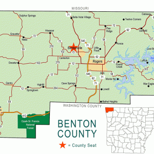
 Benton County Map
 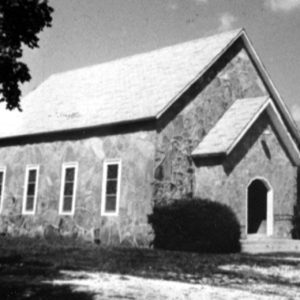 Twelve Corners Church
501-918-3025
calsfoundation@cals.org
calsfoundation@cals.org
The community of Twelve Corners, which contains one of the oldest established Baptist churches in Benton County, was pivotal to Arkansas’s history. Located three and a half miles northeast of Pea Ridge (Benton County), Twelve Corners was notable for its location on the Bentonville Detour, the former bypass from Telegraph Road in Missouri to the county seat. It was also located close to the Arkansas–Missouri state line, the Pea Ridge Plateau, and Elkhorn Tavern, which made it a significant area for a Confederate camp during the Battle of Pea Ridge.
Settlement in the northwest corner of Arkansas Territory began around 1828. In 1842, some of the earliest homesteaders in the area formed the Benton County Baptist Society in an upper room of pioneer William Ruddick’s home at the southeast end of Big Mountain, now called Elkhorn Mountain. Ruddick, a miller from Illinois (whose name is sometimes rendered Reddick or Riddick), had arrived with his family around 1830. With the help of Samuel Burks—husband of his oldest daughter, Julia—he built one of the first homes in the area.
Within ten years, the Baptist Society outgrew Ruddick’s home and sought a permanent location. John and Margaret Buttry arrived from eastern Tennessee by 1850 and homesteaded on the Bentonville Detour near an intersection with Ford Road running below the south slope of Big Mountain. The Buttrys donated land near their home for the Twelve Corners church, school, and cemetery. Relatives and friends settled nearby; most came from a Baptist church in eastern Tennessee also called Twelve Corners.
Historian Alvin Seamster dated the first Twelve Corners Church building to the early 1850s. The log structure followed the Tennessee design, with twelve corners formed by a shallow entrance annex facing south. A similar extension was on the opposite end of the main room. The interior was simply finished, with log benches and four glazed windows along the walls. Wood stoves heated the building, and it burned down more than once; it was always rebuilt according to the original plan. The church building, being the center of the community, resulted in the area’s unique name.
Several railroads came through Benton County in the 1880s and 1890s, opening up more markets and stimulating the apple boom from the 1890s to the 1920s. Twelve Corners and Pea Ridge made a great contribution; the 1903 Benton County atlas shows many large apple and fruit orchards. Apple brandy, cider, vinegar, and carloads of fresh and dried apples were shipped out by rail. The apple crop hit its peak in 1919, leading Benton County to become the number-one apple-producing county in the United States. After the peak, farmers had to battle diseases—especially apple scab, a fungus that leaves deformed, cracked fruit—and bad weather. Then came drought and the Great Depression; by 1936, the once-thriving apple industry had diminished, never to return to its former glory. In 1941, World War II brought even more dramatic changes with supply rationing and the loss of the young men needed to keep the farms going.
An eighth-grade certificate had been considered adequate for Twelve Corners students until June 1944, when the school board for Elementary District 129 petitioned for consolidation with Pea Ridge Elementary and High School. That September, school buses picked up students throughout the community. The Twelve Corners schoolhouse—a log schoolhouse that stood east of the church—became community property, later maintained and used by the Twelve Corners Grange of the Patrons of Husbandry, a nineteenth-century organization enjoying revival as a buying cooperative.
During the 1940s, ministerial candidates in the theology department at John Brown University (JBU) in Siloam Springs (Benton County) participated in a mission program serving rural churches, including Twelve Corners Missionary Baptist Church. In those years, Immanuel Baptist Church in Rogers (Benton County) shared its baptistery with Twelve Corners and other churches.
On March 26, 1954, a tornado damaged the home of Howard and Mildred Greene and farm buildings just west of the church. It demolished the community building to the east. Grange members put up a new community building and a large concrete storm cellar, and they covered the church with a sandstone veneer. In the twenty-first century, regular services are still held in the church, and the building and historic site may be seen on Twelve Corners Road, which is off of Highway 72 going toward Pea Ridge.
For additional information:
Jines, Billie. Benton County Schools That Were. Pea Ridge, AR: B. Jines, 1989.
Mitchell, Mrs. Terry. “Twelve Corners Baptist Church.” In History of Benton County, Arkansas. Rogers: Benton County Heritage Committee, 1991.
Seamster, Alvin. “History of Twelve Corners Church.” Benton County Pioneer 12 (October 1967): 76–81.
Kate Baird Anderson
Twelve Corners, Arkansas


If you visit the historic one-room school, the cemetery, and the AOG church, it is spelled Ruddick. A few years ago, my husband and I visited the area and actually met with the head of the historical society for that area. He said there had been a lot of debate over the original spelling but, in the end, they had proved that the spelling was Ruddick, not Reddick or Riddick as the name was later changed by some. William Ruddick was my husband’s great-great-grandfather.
I was born in 1971 and raised in the church. A transformer was hit by lightning in 1978, but the building was not replaced. However, the interior has been remodeled. My parents have lived in the same quarter mile of the church since the early 1940s when my dad was born.