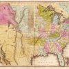
 Louisiana Purchase through Early Statehood, 1803 through 1860
501-918-3025
calsfoundation@cals.org
calsfoundation@cals.org
Perhaps the most forgotten expedition to explore the southwest territory of the Louisiana Purchase was the ill-fated 1806 journey by Thomas Freeman and Peter Custis, initially labeled “The Great Excursion” by President Thomas Jefferson, who wanted the endeavor to chart and explore both the Red and Arkansas rivers. In the end, Freeman and Custis were tasked to ascend the Red River in search of its headwaters, along the way documenting coordinates, climate, and ecological findings. The expedition would pass through the southwest corner of what would become Arkansas and its borders with Texas, Louisiana, and Oklahoma.
In selecting a civilian leader, the president designated Thomas Freeman, a 1784 Irish immigrant and Philadelphia, Pennsylvania, surveyor. Although he had no field experience, Peter Custis, a University of Pennsylvania medical student from a prominent Virginia family, served as an academically trained naturalist for the team. Making up the rest of the twenty-four-man expeditionary party was Captain Richard Sparks, a Lieutenant Humphrey (first name unknown), two non-commissioned officers, seventeen privates, and a black servant. Congress appropriated $5,000 for the venture, making it the largest, costliest, and best-equipped expedition of the first decade of the nineteenth century.
The party was conveyed on two flat-bottomed barges and a pirogue, departing on April 19, 1806, from Fort Adams in Mississippi Territory (thirty-eight miles south of Natchez), at what had been until then the southwest corner of entry into the United States. The team first went up the Mississippi River to Saint Catherine’s landing outside Natchez for additional equipment from William Dunbar and then proceeded to the Red River. Entering the Red River on May 2, they reached Natchitoches on May 19, where they took on additional equipment, soldiers, five boats, and French guides, now reaching a contingency of fifty. On June 7, the team was forty-five miles above Natchitoches, camping at the highest white settlement on the river. The next day, news arrived that Spanish forces intended to intercept and halt their journey. Having reached a “raft” (logs and brush blocking the river), the party proceeded, working its way around it, but within a few days, it reached a larger blockage known as the “Great Raft” or “Red River Raft.” The team slogged through swamps, bayous, and backwater for fourteen days before it was clear of the jam and again in the channel of the Red River, now some 200 miles up river from Natchitoches.
On June 23, the Freeman-Custis expedition arrived at a Creek (Muscogee) Indian Coashutta village near the present Arkansas border. Custis, in describing the river valley region, commented that “were the rafts removed so as to admit navigation to this country in a very short time it would become the Paradise of America.” Neighboring Caddo Indians arrived at the village on July 1. Together, the Caddo and Creek enjoyed the arrival of the explorers and accepted news that the United States now ruled the land. Both tribes warned the expedition of Spanish soldiers seeking to block their path.
The expedition departed on July 11, adding three Caddo guides. It reached a prairie, the site of an old Caddo village and abandoned French military post, on July 25. Armed with news once again from a Native American messenger about the pursuing Spanish force, the expedition put aside a reserve of provisions and field notes and proceeded upriver.
On July 28, the expedition encountered the Spanish force, four times the size of the expedition, camped on a bluff on the west side of the river, known ever since as “Spanish Bluff.” The expedition camped on the opposite, Arkansas side. The expedition was now roughly 615 miles above the mouth of the 1,360-mile Red River. The leader of the Spanish forces met Freeman and Custis, directing the expedition go no farther, claiming that the Americans were in Spanish territory. Freeman’s written instructions from President Jefferson addressed just such a situation, ordering the expedition to return in the face of a superior force arrayed against them. The expedition therefore started its return trip on July 30, reaching Natchitoches by the end of the following month. However, Custis had been able to prepare descriptions of more than 267 plants and animals found along the journey, and Freeman had charted the coordinates of the river.
Freeman returned to surveying and was appointed U.S. surveyor general, working in the Mississippi Territory. Custis returned to medical school, earning his degree in 1807 and becoming a country doctor in Bern, North Carolina. Fifty years after the exploration, it was discovered that General James Wilkinson, commander at Fort Adams and the first governor of the portion of the Louisiana Purchase north of the 33rd parallel, betrayed American interests to Spain. Working with the Spanish, he encouraged armed response to all expeditions into the Louisiana Purchase.
Three more expeditions (1819, 1852, 1876) over seventy years explored the Red River before the headwaters were reached, making it the last major western river to be charted. According to historian Dan Flores, “there is today not a single historical marker in Louisiana, Arkansas, Texas, or Oklahoma, to indicate that this expedition ever actually took place.” Despite the lack of markers, the Freeman-Custis Expedition was the first exploration team up the Red River following the Louisiana Purchase, and its findings provided the first glimpse of life along the Red River for the United States.
For additional information:
Allen, Milford F. “Thomas Jefferson and the Louisiana-Arkansas Frontier.” Arkansas Historical Quarterly 20 (Spring 1961): 39–64.
Cox, Isaac Joslin. “The Freeman Red River Expedition.” Proceedings of the American Philosophical Society 92 (May 5, 1948): 115–119.
Flores, Dan. “Freeman-Custis Expedition.” Discovering Lewis & Clark. https://lewis-clark.org/related-explorers/freeman-custis-expedition/(accessed April 4, 2022).
Flores, Dan L., ed. Southern Counterpart to Lewis and Clark: The Freeman and Custis Expedition of 1806. Norman: University of Oklahoma Press, 1984.
John Spurgeon
Bella Vista, Arkansas


The expedition is mentioned on a historical plaque in Natchitoches, La. The location is on 2nd street at the Event Center. Not sure when this plaque was placed in this location.