 Hiking
 Maumelle River Bridge
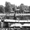 Recreation and Sports
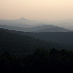 Flatside Wilderness Area
  Maumelle River Bridge
501-918-3025
calsfoundation@cals.org
calsfoundation@cals.org
The Ouachita National Recreation Trail, an approximately 225-mile back country trail, runs east and west the length of the Ouachita Mountains. More commonly referred to as the “Ouachita Trail,” it lies primarily within the Ouachita National Forest.
Most of the trail (177 miles) is in Arkansas, with forty-six miles extending into Oklahoma. Both ends of the trail are in state parks. The eastern terminus is in Pinnacle Mountain State Park west of Little Rock (Pulaski County); the western terminus is in Talimena State Park in Oklahoma. The trail also crosses a third state park, Queen Wilhelmina State Park in Polk County. Terrain across the length of the trail is rugged, providing a variety of hiking experiences and scenic opportunities. Elevation ranges from a high point of 2,600 feet above sea level on Rich Mountain, near the Arkansas-Oklahoma state line, to a low of approximately 300 feet near Lake Maumelle in Pulaski County. Climbs between 1,000 feet and 1,500 feet are common. Two designated wilderness areas enhance enjoyment of the trail—the Upper Kiamichi Wilderness (Oklahoma) and the Flatside Wilderness (Saline and Perry counties in Arkansas).
Although short segments of the trail apparently date back to the Civilian Conservation Corps (CCC) era, the Ouachita Trail was constructed between 1971 and 1981. It was certified by the National Recreation Trails Program in 1978. Various agencies, including the U.S. Forest Service (USFS) and Arkansas State Parks, constructed the trail, with a great deal of help from volunteer groups. Today, the Ouachita Trail is administered primarily by the U.S. Forest Service, with 192 miles of the trail within the Ouachita National Forest. The thirty miles east of the national forest are administered by Pinnacle Mountain State Park.
Originally intended as a foot trail, the entire length is open to day hikers and backpackers. Since 2000, portions of the trail totaling about 140 miles have been opened to mountain bikers. In addition to the state parks, forest service recreation areas provide campground facilities along the trail—Winding Stair in Oklahoma, Big Brushy in Montgomery County, and Lake Sylvia in Perry County. A string of nine overnight shelters further enhance the experience for backpackers. Camping is also allowed along the trail, except in the designated wilderness areas.
Wildlife is abundant along the length of the trail. White-tailed deer are seen regularly along with smaller mammals, especially rodents such as squirrels and chipmunks. An occasional black bear may be spotted. Bird life is abundant, with bald eagle sightings possible near Lake Ouachita. Snakes seen on the trail include the copperhead, diamondback rattler, and water moccasin.
For much of its history, maintenance of the Ouachita Trail has been a problem, and trail usage suffered. Following a devastating ice storm in 2000, renewed attention to the trail has been shown by the USFS, Arkansas State Parks, and volunteers. An all-volunteer group, Friends of the Ouachita Trail (FoOT), was founded in 2003 to provide assistance for the maintenance, enhancement, and use of the Ouachita National Recreation Trail. Today, the trail is in good shape and well marked with the traditional blue trail blazes. Trail usage is up sharply. Hikers, backpackers, and mountain bikers from across Arkansas and neighboring states enjoy the diversity of mountain views, rock formations, rivers, streams, and wildlife along the route.
For additional information:
Ernst, Tim. Ouachita Trail Guide #4. Pettigrew, AR: Cloudland.net Publishing, 2006.
Friends of the Ouachita Trail (FoOT). https://www.friendsoftheouachita.org (accessed February 9, 2023).
National Recreation Trails. https://www.americantrails.org/national-recreation-trails#:~:text=What%20is%20an%20NRT%3F,Federal%2C%20State%20and%20local%20lands. (accessed February 9, 2023).
Ouachita National Forest. United States Forest Service. http://www.fs.usda.gov/ouachita (accessed February 9, 2023).
Rawlins, Jim. A Hiker’s Guide to the Ouachita National Recreation Trail. North Little Rock, AR: James W. Rawlins, 1985.
Jim Gifford
Friends of the Ouachita Trail


Comments
No comments on this entry yet.