calsfoundation@cals.org
Memphis-Arkansas Memorial Bridge
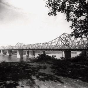
The Memphis-Arkansas Memorial Bridge on Interstate Highway 55 connects Arkansas with Tennessee at Memphis. Since its opening on the morning of December 17, 1949, the span has served as a vital link for automotive traffic to cross the Mississippi River.
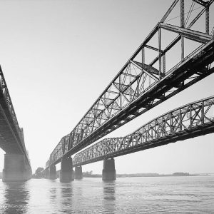
When the Frisco Bridge was built for railroads in 1892, automobile traffic was not a factor. The Harahan Bridge, the second bridge linking Arkansas and Tennessee, opened in the summer of 1916. Due to increasing numbers of automobiles on both sides of the river, carriageways were hung off both sides of the Harahan in 1917. These provided a single lane for traffic on either side of the bridge.
Although Arkansas cars could cross the Mississippi River at Memphis beginning in 1917 rather than having to drive to the nearest bridge in St. Louis, the need for a span dedicated to automobile traffic and carrying multiple lanes in each direction quickly became apparent. The necessity for such a structure was illustrated even more clearly in September 1928 when the partially wooden Harahan Bridge caught fire. The blaze at the bridge’s center proved especially difficult to extinguish. The Memphis Fire Department was forced to load pumping trucks on available boats to reach over the water to the fire. Despite this effort, over 700 feet of roadway on the Harahan were damaged. The region’s only bridge for automobile traffic remained closed for a year and a half while repairs were under way.
Although this event highlighted the need for a second automobile bridge, it was twenty-one years before such a structure opened to traffic. Until that time, traffic on the Harahan increased substantially. By the time the second span, the Memphis-Arkansas Bridge, finally opened, the daily volume of automobiles using the Harahan’s two lanes had increased to 11,000. Stalled vehicles and slow farm implements frequently caused substantial delays. As the Harahan had only one lane on either side of the railroad tracks, passing was impossible. Although the Memphis-Arkansas Bridge began carrying most cross-river traffic when it opened in 1949, some farm vehicles still utilized the Harahan Bridge until 1954.
A local bridge commission formed in 1939 to lobby and plan for what would become the Memphis-Arkansas Bridge. Later that year, the Seventy-sixth Congress appropriated money for its construction. Historians often credit Memphian and political power broker Edward Hull Crump, who chaired the bridge commission, with securing funding and resources for the large building project in the midst of the Great Depression and on the eve of World War II.
The Memphis-Arkansas Bridge cost $10.5 million, or $13.6 million when the cost of building and widening the bridge accesses is included. Mindful of the inferno that consumed and crippled the partially wooden Harahan, engineers designed a steel structure for the Memphis-Arkansas Bridge. Designed by Modjeski and Masters Engineers, the bridge features a cantilever design. It has two concrete-paved lanes running in each direction across the river. In the 1970s, a barrier wall was built to replace the median strip that initially separated opposing traffic. Like the nearby Hernando de Soto Bridge, opened in 1973, the Memphis-Arkansas Bridge was not constructed to withstand an earthquake, a phenomenon threatened by the New Madrid fault to the north. Unlike the Hernando de Soto Bridge, it cannot be retrofitted with such protection.
The location of the Memphis-Arkansas Bridge, in close proximity to the Frisco and Harahan bridges, was chosen by the engineers over a site to the north near Winchester Avenue that would have crossed Mud Island. They concluded that the site near Iowa Avenue—later E. H. Crump Boulevard—would be more accessible to motorists and do more to relieve traffic congestion. The Mud Island location would have been almost twice as expensive, and some feared that the forty-year-old island would disappear since the Brandywine Chute, the silting of which had formed the island, was again open.
The increased vehicular traffic capacity offered by the Memphis-Arkansas Bridge facilitated the growth of West Memphis (Crittenden County) as a national trucking center. It also reflected the growth in population of communities on both river shores and, more broadly, the population growth of Arkansas and western Tennessee.
The Memphis-Arkansas Bridge was listed on the National Register of Historic Places on February 26, 2001. It continues to serve as a vital automobile conduit for cross-river traffic, although it carries fewer cars the newer Hernando de Soto Bridge to the north. In 2023, state highway agencies in both Arkansas and Tennessee applied for funding available through a federal 2021 infrastructure law to replace the bridge, citing specifically the fact that the bridge was not designed to withstand the earthquakes possible in the New Madrid Seismic Zone.
For additional information:
Callahan, Jody. “Decades-old Span Links Ark., Tenn. at River.” Commercial Appeal. August 2, 2007, pp. 1A, 5A.
Crawford, Charles W. Yesterday’s Memphis. Miami: E. A. Seemann Publishing, Inc., 1976.
Downing, Shirley. “M&A Bridge spans 50 years, memories.” Commercial Appeal. December 17, 1999, pp. 1A, 8A.
Holt, Tony. “Arkansas, Tennessee Seek I-55 Bridge Aid.” Arkansas Democrat-Gazette, December 10, 2023, pp. 1A, 10A. Online at https://www.arkansasonline.com/news/2023/dec/10/arkansas-tennessee-seek-i-55-bridge-aid/ (accessed December 11, 2023).
“Memphis and Arkansas Bridge.” National Register of Historic Places nomination form. On file at Arkansas Historic Preservation Program, Little Rock, Arkansas. Online at http://www.arkansaspreservation.com/National-Register-Listings/PDF/CT0108.nr.pdf (accessed September 28, 2022).
“Memphis and Arkansas Highway Bridge Over the Mississippi River Final Report.” Memphis and Shelby County Room. Memphis Public Library and Information Center, Memphis, Tennessee.
Charles W. Crawford
Memphis, Tennessee
 Garver, Neal Bryant
 Transportation
 Memphis-Arkansas Memorial Bridge
  Memphis-Arkansas Memorial Bridge


Comments
No comments on this entry yet.