 Ozark Highlands Trail
501-918-3025
calsfoundation@cals.org
calsfoundation@cals.org
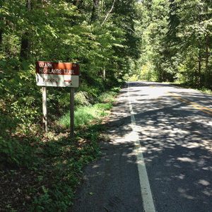
The Ozark Highlands National Recreation Trail is a 165-mile-long hiking and backpacking route across northwestern Arkansas. The trail’s western terminus is Lake Fort Smith State Park in Crawford County, and its eastern terminus lies within the Buffalo National River park in Searcy County. The trail runs almost entirely through the Ozark National Forest, which regulates use.
The Ozark Highlands Trail (OHT), as it is often called, was created by the National Forest Service in the 1970s, though inadequate federal funding limited route planning and construction to short segments. In response, area hiking enthusiasts in 1981 formed the Ozark Highlands Trail Association (OHTA). This all-volunteer group took over trail design and construction, completing the OHT in 1984. The association, working in cooperation with the Ozark National Forest, has continued to maintain the OHT, making small changes in places along the route to avoid roads, protect natural resources, provide better access to scenic areas, and otherwise improve the experience for hikers.
The OHT is blazed with white, rectangular aluminum markers affixed to trees. Brown posts along the route show mileage, which is calculated beginning at the western terminus. Hare Mountain, at 2,380 feet the trail’s highest point, is located at mile forty-three.
The OHT runs through the Ozark Plateau region, an uplifted ancient seabed. Originally flat, the plateau has been heavily eroded by streams and weather, creating a rugged landscape of countless ridges and valleys. The underlying rock is predominately sandstone and limestone, with many tall bluffs bordering rivers and creeks.
Terrain along the trail is heavily forested, with oaks, hickories, gums, and shortleaf pine the most common trees. Decades of logging have left virtually no primary-growth forest, though timber harvest is now restricted in the OHT corridor.
Wildlife along the OHT includes birds such as the broad-winged hawk; wild turkey; yellow-billed cuckoo; pileated woodpecker; red-eyed vireo; and cerulean, worm-eating, and hooded warbler. Mammals include bobcats, white-tailed deer, raccoons, foxes, and gray squirrels. Black bears have been reintroduced into the Ozark region after being extirpated in the early twentieth century. The bear population is growing, and campers along the OHT are urged to store food securely away from tents and take other bear-country precautions. Bear sightings are rare, however.
The nature of the landscape means much of the trail is at least moderately strenuous, with near-constant climbs and descents. Nonetheless, hikers of all abilities can find sections of the trail to enjoy. The OHT intersects often with Forest Service roads, county roads, and highways, allowing for day hikes of varying lengths. Experienced backpackers who plan ahead and cache food or arrange resupply drops can hike the OHT end to end in ten days to two weeks.
Though only fourteen miles of the OHT lie within an officially designated wilderness area (Hurricane Creek Wilderness), most of the trail is quite remote and provides a near-wilderness experience. There are no bridges along its length, so springtime hikers should be prepared to wade across streams in many spots. Such crossings should be undertaken with care, as strong currents can cause hikers to lose their footing on slippery rocks and be swept downstream.
A separate thirty-one-mile section of the OHT has been completed in the Sylamore District of the Ozark National Forest, northwest of Mountain View (Stone County). This segment is part of a long-term plan to link the OHT to the Ozark Trail in Missouri, currently under development. Such a linkage would, upon completion, create a hiking trail of around 700 miles, stretching from St. Louis nearly to the Oklahoma border.
Primitive camping is allowed anywhere in the Ozark National Forest as long as the campsite is out of sight of the OHT and more than 200 feet from the trail or a water source. Mountain biking, horseback riding, and off-road vehicles are prohibited along the trail.
For additional information:
Ernst, Tim. Ozark Highlands Trail Guide #5. Pettigrew, AR: Cloudland.net Publications, 2007.
National Recreation Trails. https://www.americantrails.org/national-recreation-trails (accessed February 28, 2022).
Ozark Highland Trails Association. https://ozarkhighlandstrail.com/ (accessed February 28, 2022).
Robinson, Bob. “Backpack Adventure.” Arkansas Democrat-Gazette, January 22, 2024, pp. 1D, 6D. Online at https://www.arkansasonline.com/news/2024/jan/21/backpack-adventure-three-day-bushwhack-on-the/ (accessed January 22, 2024).
———. “Clearing the Path.” Arkansas Democrat-Gazette, September 25, 2023, pp. 1D, 6D. Online at https://www.arkansasonline.com/news/2023/sep/24/defenders-of-ozark-highlands-trail-gather-to-do/ (accessed September 25, 2023).
White, Mel. “The Intimate Wild.” National Geographic, October 2008, 122–139. Online at http://ngm.nationalgeographic.com/2008/10/ozark-trail/white-text (accessed February 28, 2022).
Mel White
Little Rock, Arkansas


Comments
No comments on this entry yet.