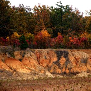
 Loess Soil
501-918-3025
calsfoundation@cals.org
calsfoundation@cals.org
Arkansas has a diversity of rich soils that developed in a favorable environment for growing plants. The soils of Arkansas are the foundation of the number-one industry in the state—agriculture. Arkansas soils are natural, dynamic bodies of broken-down and weathered mineral and organic matter, in some places altered by human activity, capable of growing plants. Soils are unique and exist as a creation of five soil-forming factors: parent material, climate, topography, organisms, and time. Soil parent material is the geological source of the mineral component, defined as particles less than two millimeters in diameter. Arkansas soils developed from residium, loess, alluvium, and old marine sediment parent materials.
Residium is weathered rock, and Arkansas’s residium is mostly soil derived from sandstone, siltstone, shale, and limestone found in the Ozark, Boston, and Ouachita mountain regions. Many of these soils are gravelly or rocky, and the steep topography limits their use to primarily pasture, woodland, or wildlife habitat rather than row crop agriculture. Loess is silt-sized, wind-deposited soil particles that accumulated mostly during immense dust storms associated with climatic changes during the ice ages. Loess soils in Arkansas are usually less than 50,000 years old, and they are found primarily in eastern Arkansas. Crowley’s Ridge, for example, is an ice-age river valley erosion surface remnant having soils formed from loess particles that settled onto the ridge. Alluvial soils are composed of clay to fine sand deposits found in ancient or contemporary flood plains of river systems. These soils are very productive and can be found all over the state in major and minor river valleys. The alluvial soils of the vast Arkansas and Mississippi river valleys are some of the most productive agricultural soils in the state. The Mississippi River alluvial soils of eastern Arkansas make up the Delta region of the state. Soils derived from ancient marine deposits occupy the southern part of Arkansas. This region of the state was once part of the Gulf of Mexico, and soils have developed over hundreds of thousands of years from the marine sediments.
As soils age, they develop layers called soil horizons that form due to the effects of the soil-forming factors on physical and chemical weathering processes. Soils that form in similar parent material, age, topography, and climate—and with horizons that are similar in texture, structure, colors, and thickness—are grouped together in descriptive units called soil series. The soil series is often named for a town or feature near the place where soil scientists first made a detailed description of the soil profile. A modifier with the soil texture of the surface horizon is then added to the name. In Arkansas, one can find such soil series as the Fayetteville fine sandy loam in the Boston Mountains region of northwestern Arkansas, the Clarksville very cherty silt loam in the Ozark highlands of north-central Arkansas, the Clebit very cobbly loam soil that formed from sandstone residium in the Ouachita Mountains of west-central Arkansas, the Dardanelle silt loam in the Arkansas River Valley of central Arkansas, and Tunica clay in the Mississippi River Valley of northeast Arkansas. Grenada silt loam developed in loess deposits on Crowley’s Ridge and other highland regions of eastern Arkansas, and the Savannah fine sandy loam soil formed in old marine sediments in southern Arkansas. In the Delta, the Sharky clay soil series is a dark-colored, clayey soil formed from Mississippi River slack water depositions and is known as “buckshot” by the farmers. Sharky clay is a productive agricultural soil.
The Arkansas General Assembly of 1997 adopted the Stuttgart silt loam soil series as the official soil of Arkansas. The Stuttgart silt loam series formed on a vast Pleistocene-aged stream terrace in level or nearly level topography and occupies approximately 200,000 acres (81,000 hectares) in eastern Arkansas. It has a silt loam textured loess-alluvium mixed surface layer underlain by silt loam to silty clay loam alluvial deposits of the old Pleistocene stream terrace. The primary crops grown on the Stuttgart series are rice and soybeans, and it is one of the most productive soils in the state, responsible for millions of dollars of crop harvest each year. The city of Stuttgart (Arkansas County) owes its existence in part to the Stuttgart silt loam soil.
Many other soil series can be found in Arkansas, each with unique combinations of characteristics and potentials for utilization. The United States Department of Agriculture–Natural Resources Conservation Service (USDA-NRCS) has published soil surveys and digital soil maps for every county in Arkansas. Soil surveys contain maps of the soils, soil descriptions, and tables with limitations for management of the soils for uses such as agriculture, forestry, wildlife, and engineering. The county soil survey is a valuable tool for farmers, environmentalists, conservationists, engineers, city planners, real estate agents, and others who need to know the soils of an area. The soils of Arkansas are one of the state’s most important natural resources.
For additional information:
Anderson, Rebecca Lynn. “Landuse and Soil Property Effects on Infiltration and Soil Aggregate Stability in the Lower Mississippi River Valley.” MS thesis, University of Arkansas, 2019. Online at https://scholarworks.uark.edu/etd/3144/ (accessed July 6, 2022).
Brady, N. C., and R. R. Weil. The Nature and Properties of Soils. 14th ed. Columbus, OH: Pearson/Prentice Hall, 2008.
Soil Survey Division Staff. Soil Survey Manual. U.S. Department of Agriculture Handbook 18. Washington DC: Soil Conservation Service, 2003.
Paul B. Francis
University of Arkansas at Monticello


Comments
No comments on this entry yet.