 Climate and Weather
 Flood of 1978
 Flood of 2019
 Levees and Drainage Districts
 Tropical Cyclones
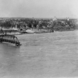 Baring Cross Bridge; 1927
  Batesville 1915 Flood
 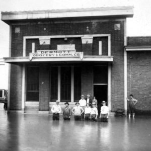 Dermott 1927 Flood
 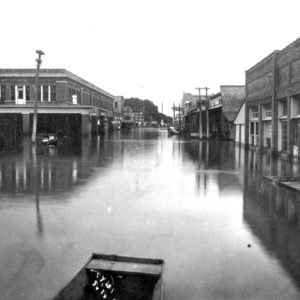 Dermott 1927 Flood
 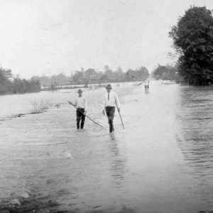 Dixie 1927 Flood
  Flooded Highway
 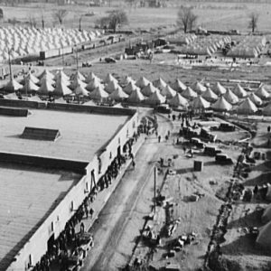 Forrest City Refugee Camp
 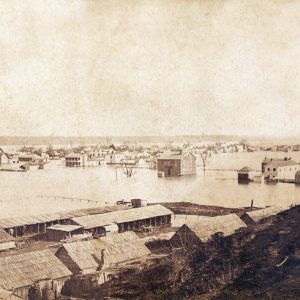 Fort Curtis
 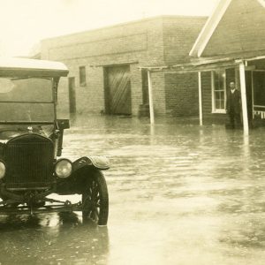 Fulton 1927 Flood
 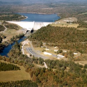 Greers Ferry Dam
 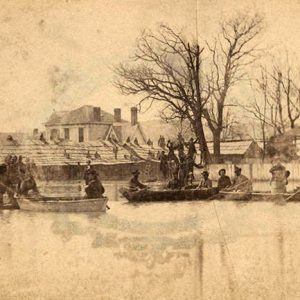 Helena Flood
 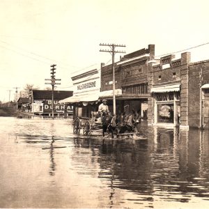 Hughes Flood
 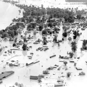 Lake Village Flood
 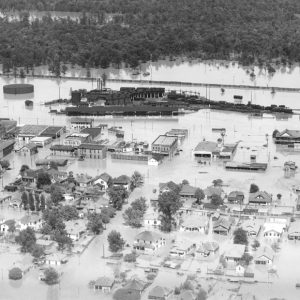 McGehee Flood
 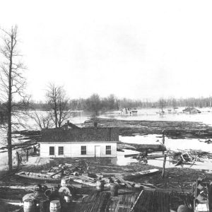 West Memphis Flood
  Williford Flood
501-918-3025
calsfoundation@cals.org
calsfoundation@cals.org
Floods are one of the most commonly occurring natural hazards in the United States. Their effects can be local, impacting a neighborhood or community, or can occur in large scale, affecting entire river basins and several states. About 3,800 towns and cities in the United Sates with populations of more than 2,500 lie on floodplains. The National Weather Service has documented some ninety-two flood deaths per year in the United States since 1903. This figure does not include flood-related deaths associated with Hurricane Katrina (2005). Since 1997, more than half (about fifty-seven percent) of all flood deaths have been vehicle-related fatalities. Throughout its history, Arkansas has been drastically affected by floods, with the most notable being in 1927 and 1937.
The reasons for flooding relate to climatology, topography, and size of river basin. Arkansas frequently sees a pattern of subtropical moisture flows from the Gulf of Mexico. As this moisture lifts from the Gulf and encounters mountainous terrain, it triggers convective instability, which often leads to large, multi-celled, persistent thunderstorm systems. These can produce significant rain events resulting in flooding. Rivers that begin in highland areas of the Ozark or Ouachita mountains and flow into the Mississippi Delta (White, Black, and St. Francis rivers) or the Gulf Costal Plain (Ouachita and Little Missouri rivers) are particularly prone to large-scale flooding by the time they reach the lowlands. High flows on the Arkansas, Red, and Mississippi rivers are most often the result of heavy rains that have saturated the ground over an extensive area. Persistent thunderstorm activity in Arkansas can trigger large-scale flood events along these big river basins.
Flash flooding is perhaps the most dangerous type of flooding to occur, as it can develop quickly and affect an area without warning, as in the 2010 Little Missouri flood at the Albert Pike Recreational Area. This type of flood is produced by heavy downpour rains in steep terrain and results in a wall of water that carries rocks, mud, and other debris and sweeps away everything in its path. Overland flooding, covering a wide area, may occur during a levee break. Emergency dam releases or dam failure can also cause extensive, sudden flood disasters similar to flash floods.
Natural flooding is essential and beneficial to wetlands and bottomland forests. Lower floodplain levels are naturally flooded each year in Arkansas about forty percent of the time. Historically, however, much of the problem with flood disasters has resulted from the corruption of natural ecosystems and encroaching development on floodplains.
Congress passed the first Flood Control Act in 1917, which appropriated $45 million for flood control on the lower Mississippi. Prior work had consisted mostly of small-scale, local, private efforts. What federal levee work had been done was tied to navigational interests. After the passage of the Flood Control Act of 1928 (spurred by widespread and disastrous flooding in 1927), federal work on flood control increased dramatically. Studies of river tributaries, along with prospective reservoir and levee projects, began to multiply as Congress approved civil works projects under the U.S. Army Corps of Engineers. The U.S. Geological Service and National Weather Service increased efforts in river stage monitoring and flood science. In 1968, the National Flood Insurance Act offered new flood protection programs to homeowners. Seeking to decrease the many agencies with which state and local governments were forced to work, the National Governor’s Association asked President Jimmy Carter to centralize federal emergency functions. He responded by issuing Executive Order 12127 in 1979. This merged many separate disaster-related responsibilities into the Federal Emergency Management Agency (FEMA). Today, FEMA is largely responsible for the implementation of federal hazard-reduction policies and floodplain management.
Despite these efforts, damage from flooding continues to escalate. This trend is mainly due to increased development on floodplains as government programs began offering flood insurance and flood relief assistance.
Decadal Annual Average of National Flood Damage Estimates—National Weather Service Data:
| Decade | Average Annual Estimate in Current U.S. $ |
| 1930–1939 | $105.1 million |
| 1940–1949 | $130.9 million |
| 1950–1959 | $344.5 million |
| 1960–1969 | $368.2 million |
| 1970–1979 | $1,548.5 million |
| 1980–1989 | $2,561.1 million
(data from 1980–1982 not available) |
| 1990–1999 | $4,927.5 million |
U.S. Geological Survey (USGS) flood damage estimates in 2006 put average annual national losses at about $6 billion and 140 deaths. Total claim payments from the National Flood Insurance Program for Arkansas alone in fiscal year 2010 totaled $17.3 million. The number of policies issued by the program in Arkansas grew by five percent in fiscal year 2010. From 1965 to 2004, the counties in Arkansas to receive the most presidential disaster declarations (thirteen to fifteen) were: Columbia, Craighead, Independence, Jackson, Poinsett, and Pulaski. Eighty percent of all presidential disaster declarations involve floods.
Historic Arkansas Floods
The following table indicates historic flood years on Arkansas’s seven largest rivers using USGS data from Magnitude and Frequency of Floods in Arkansas (1995). The data for these rivers was reprinted from an earlier report and ended with years 1980–1984. Stage levels and flows from numerous gauging stations were compared. In most cases, only floods from about two feet over bank full or higher were included. The number of gauge stations on a river and their dates of record varied. In some years, floods occurred only at one station, while in other years, flooding occurred at all stations on a given river.
Key: * denotes significant flood; † denotes beginning year of data; ‡ denotes ending year of data
| White River | Black River | St. Francis River | Mississippi River | Arkansas River | Ouachita River | Red River | |
| 1828 | † | ||||||
| 1829 | |||||||
| 1830 | |||||||
| 1831 | |||||||
| 1832 | |||||||
| 1833 | †* | ||||||
| 1834 | |||||||
| 1835 | |||||||
| 1836 | |||||||
| 1837 | |||||||
| 1838 | |||||||
| 1839 | |||||||
| 1840 | |||||||
| 1841 | |||||||
| 1842 | |||||||
| 1843 | |||||||
| 1844 | * | ||||||
| 1845 | |||||||
| 1846 | |||||||
| 1847 | |||||||
| 1848 | |||||||
| 1849 | |||||||
| 1850 | |||||||
| 1851 | |||||||
| 1852 | |||||||
| 1853 | |||||||
| 1854 | |||||||
| 1855 | |||||||
| 1856 | |||||||
| 1857 | |||||||
| 1858 | |||||||
| 1859 | |||||||
| 1860 | |||||||
| 1861 | |||||||
| 1862 | |||||||
| 1863 | |||||||
| 1864 | |||||||
| 1865 | |||||||
| 1866 | |||||||
| 1867 | |||||||
| 1868 | |||||||
| 1869 | |||||||
| 1870 | |||||||
| 1871 | |||||||
| 1872 | |||||||
| 1873 | |||||||
| 1874 | * | ||||||
| 1875 | |||||||
| 1876 | * | ||||||
| 1877 | * | ||||||
| 1878 | * | ||||||
| 1879 | |||||||
| 1880 | |||||||
| 1881 | |||||||
| 1882 | |||||||
| 1883 | |||||||
| 1884 | * | ||||||
| 1885 | * | ||||||
| 1886 | † | ||||||
| 1887 | |||||||
| 1888 | |||||||
| 1889 | |||||||
| 1890 | * | ||||||
| 1891 | |||||||
| 1892 | * | * | |||||
| 1893 | * | * | * | ||||
| 1894 | |||||||
| 1895 | |||||||
| 1896 | |||||||
| 1897 | * | ||||||
| 1898 | * | * | * | ||||
| 1899 | |||||||
| 1900 | |||||||
| 1901 | |||||||
| 1902 | |||||||
| 1903 | * | † | |||||
| 1904 | * | ||||||
| 1905 | † | ||||||
| 1906 | * | * | |||||
| 1907 | * | * | * | ||||
| 1908 | * | ||||||
| 1909 | * | * | |||||
| 1910 | |||||||
| 1911 | |||||||
| 1912 | * | * | |||||
| 1913 | * | ||||||
| 1914 | * | ||||||
| 1915 | * | * | * | ||||
| 1916 | * | * | † | * | * | ||
| 1917 | * | ||||||
| 1918 | * | † | |||||
| 1919 | |||||||
| 1920 | * | * | |||||
| 1921 | * | * | |||||
| 1922 | * | * | |||||
| 1923 | * | * | * | ||||
| 1924 | |||||||
| 1925 | |||||||
| 1926 | |||||||
| 1927 | * | * | * | * | * | * | * |
| 1928 | * | * | * | * | |||
| 1929 | * | * | * | * | * | ||
| 1930 | * | * | * | * | |||
| 1931 | |||||||
| 1932 | * | * | * | ||||
| 1933 | * | * | * | * | |||
| 1934 | |||||||
| 1935 | * | * | * | * | * | * | * |
| 1936 | * | ||||||
| 1937 | * | * | * | * | * | ||
| 1938 | * | * | * | * | * | ||
| 1939 | * | * | * | ||||
| 1940 | |||||||
| 1941 | * | ||||||
| 1942 | * | * | * | ||||
| 1943 | * | * | * | ||||
| 1944 | * | * | |||||
| 1945 | * | * | * | * | * | ||
| 1946 | * | * | * | * | |||
| 1947 | * | ||||||
| 1948 | * | * | |||||
| 1949 | * | * | * | * | * | ||
| 1950 | * | * | * | * | * | * | |
| 1951 | * | * | |||||
| 1952 | * | * | * | ||||
| 1953 | |||||||
| 1954 | |||||||
| 1955 | |||||||
| 1956 | * | * | |||||
| 1957 | * | * | * | * | |||
| 1958 | * | * | * | ||||
| 1959 | |||||||
| 1960 | * | * | |||||
| 1961 | * | * | * | * | |||
| 1962 | * | ||||||
| 1963 | |||||||
| 1964 | * | * | |||||
| 1965 | |||||||
| 1966 | * | * | |||||
| 1967 | |||||||
| 1968 | * | * | |||||
| 1969 | * | * | * | * | * | ||
| 1970 | * | ||||||
| 1971 | |||||||
| 1972 | * | * | |||||
| 1973 | * | * | * | * | * | ||
| 1974 | * | * | * | * | * | ||
| 1975 | * | * | * | * | |||
| 1976 | * | * | |||||
| 1977 | * | * | |||||
| 1978 | * | ||||||
| 1979 | * | * | |||||
| 1980 | ‡ | ‡ | |||||
| 1981 | |||||||
| 1982 | * | ||||||
| 1983 | * | * | * | * | |||
| 1984 | ‡ | ‡ | ‡ | ‡ * | ‡ |
Two floods stand out among Arkansas’s worst flood disasters. They are the Mississippi Valley Flood of 1927 and the Ohio-Mississippi Valley Flood of 1937. According to John Barry’s 1997 book Rising Tide: The Great Mississippi Flood of 1927 and How It Changed America, in the last three months of 1926, every river gauge on the Ohio, Missouri, and Mississippi rivers set new average highs. This set the stage for record flooding the following spring. Levee breaks flooded more than two million acres of farm land in Arkansas in 1927. There were fewer levee breaks in 1937, but there was deliberate flooding of “spillways” and the use of “fuseplug” levees. The federal government had obtained flowage rights, and these emergency measures were an attempt to flood certain areas in order to alleviate flooding elsewhere. However, the dynamiting of the fuseplug levee at Charleston, Missouri, contributed to flooding and damage in Jonesboro (Craighead County). About one million acres of agricultural land were flooded in Arkansas during the 1937 flood disaster.
The two flood events were also quite different in other respects. The peak of the flooding in 1927 was in April, while the 1937 flood was in mid-winter (January through February), a far worse time in terms of rendering aid, especially since influenza and pneumonia were widespread at that time. Newly developed power plants were submerged in the 1937 flood; power lines failed and threw cities and rural areas into darkness. Although disastrous in Arkansas, the flooding in 1937 was much worse in the Ohio River Valley than in the lower Mississippi as in 1927, sparing Arkansas the brunt of the flooding.
Overall, losses in Arkansas in 1937 were much less than in 1927. The American Red Cross estimated 208,965 cases aided in Arkansas in the 1927 flood and 33,574 in 1937; the number of homes flooded, damaged, and destroyed was 85,481 in the 1927 event and 404 in 1937. Still, in terms of the total picture, both floods were destructive in Arkansas. The story of the 1937 flooding of the farmers’ resettlement colony at Dyess (Mississippi County) was popularized years later by Johnny Cash in the song “Five Feet High and Rising” (1959).
In May 1990, excessive spring rains in eastern Oklahoma and western Arkansas caused flooding along the Arkansas, White, and Red rivers. Flood control storage at a number of dams was exceeded, and emergency flood releases were made from Lake Eufaula on the Canadian River in Oklahoma (tributary to the Arkansas River), Lake Texoma (on the Red River in Texas and Oklahoma), and Beaver Lake (upper White River in Arkansas), adding to the already massive run off in the three river basins.
March and April 2008 saw heavy rainfall events fill the five U.S. Army Corps of Engineers White River reservoirs to record levels, also necessitating emergency spillway releases at Beaver, Table Rock, Bull Shoals, and Norfork dams. Flooding on the lower White River continued well into the summer months of 2008. Greers Ferry reservoir continued to see high water levels in 2009 and made spillway releases in December of that year. Flooding in 2011 affected the White River basin, particularly Des Arc (Prairie County).
Some Cities and Towns Affected by Large Floods:
| Town or City | Notable Dates/Events | River |
| Batesville (Independence County) and Newport (Jackson County) | Numerous | Newport is located on the White River below the confluence of the Black River, the White’s largest tributary. |
| Calico Rock (Izard County) | Numerous floods. The floods of 1916, 1927, 1915, and 1945 set the highest stage levels on record, respectively. | White River |
| Clarendon (Monroe County) | Numerous | Situated on the White River at the confluence with the Cache River |
| Fort Smith (Sebastian County) | May 1943 | Arkansas River |
| Georgetown (White County) | Numerous White River and tributary floods | The White River town is well below Newport and is at the confluence with the Little Red River. Historic gauge and record. |
| Harrison (Boone County) | Flood on May 7, 1961, covered eighty percent of the town’s business district. | Crooked Creek |
| Helena-West Helena (Phillips County) | Numerous floods. The floods of 1927 and 1937 did severe damage. | Mississippi River |
| Hot Springs (Garland County) | A flash flood made for a great disaster on May 14, 1923. The river stage for this flood was exceeded by flooding in March 1945. | Experienced numerous Ouachita River floods until the completion of Blakely Mountain Dam in 1952. |
| Little Rock (Pulaski County) | 1833, 1927, 1978. The 1927 flood washed out the Baring Cross Bridge. | Arkansas River |
| Marked Tree (Poinsett County) | Numerous floods. Levee breaks and resulting flooding were common place in the early part of the twentieth century. Unique lock and siphons constructed in 1939 have helped reduced flooding. | St. Francis River |
| Pine Bluff (Jefferson County) | Numerous, especially 1907. In 1927, nearly all of Jefferson County was inundated. | Arkansas River |
For additional information:
American National Red Cross. The Mississippi Valley Flood Disaster of 1927: Official Report of the Relief Operations. Washington DC: American National Red Cross, 1929.
American National Red Cross. The Ohio-Mississippi Valley Flood Disaster of 1937: Report of Relief Operations of the American Red Cross. Washington DC: American National Red Cross, 1938.
Arkansas Floodplain Management Association. http://www.arkansasfloods.org (accessed December 21, 2023).
Arkansas Natural Resources Commission Flood Plain Management Program. http://www.floodplain.ar.gov/ (accessed December 21, 2023).
Barry, John M. Rising Tide: The Great Mississippi Flood of 1927 and How It Changed America. New York: Simon and Schuster, 1997.
Bedinger, M. S., and Geological Survey (U.S.). Forest and Flooding with Special Reference to the White River and Ouachita River Basins, Arkansas. Lakewood, CO: Department of the Interior, Geological Survey, 1979.
Bolton, S. Charles, and United States. The Floods of 1990. Little Rock: U.S. Army Corps of Engineers, Little Rock District, 1990.
Cash, Johnny. Cash: The Autobiography. San Francisco: Harper San Francisco, 1997.
Devine, Robert S. “The Trouble with Dams.” Atlantic Monthly 276 (August 1995): 64–74.
Flood Damage in the United States, 1926–2000: A Reanalysis of National Weather Service Estimates. https://www.ltrr.arizona.edu/~katie/kt/FLOODS-USGS/NSF-AHIS/FLOOD-Papers/flooddamagedata.pdf (accessed December 21, 2023).
“The Great Flood of 2011.” Rex Nelson’s Southern Fried. http://www.rexnelsonsouthernfried.com/?p=2367 (accessed December 21, 2023).
Hodge, Scott A. Magnitude and Frequency of Floods in Arkansas. Water-Resources Investigations Report 95-4224. Little Rock: U.S. Department of the Interior, U.S. Geological Survey, 1995.
O’Connor, Jim E., and John E. Costa. Large Floods in the United States: Where They Happen and Why. U.S. Geological Survey Circular 1245. Washington DC: U.S. Geological Survey, 2003.
Welky, David. The Thousand-Year Flood: The Ohio-Mississippi Disaster of 1937. Chicago: University of Chicago Press, 2011.
Zhou, Xichun. “Characterizing Flooding Regimes in the Lower Mississippi Alluvial Valley over Recent Two Decades.” MS thesis, Mississippi State University, 2021. Online at https://scholarsjunction.msstate.edu/td/5291/ (accessed December 21, 2023).
Scott Branyan
Rogers, Arkansas


I was born in Greene County, Arkansas, in 1945, between the St. Francis River and Big Slough Ditch. It sometimes flooded I guess from St. Francis to our east and Big Slough to the west. Took a boat to Big Slough Levee to get to Paragould. Could be flooded by either one. I guess that’s why we got the new ditch in 1958 and our levee road that is now paved and called 139 connecting us with 412 (once 25). I believe it was 1956 and I had written on a book that Daddy and I had to go to BARD because the water was up to our east and our normal way to get to 25 to go to Paragould or Cardwell, Missouri. My grandpa was raised on DeMent Island in the St. Francis close to Bertig.