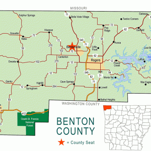
 Benton County Map
 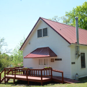 Coal Gap School
 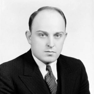 Clyde Ellis
 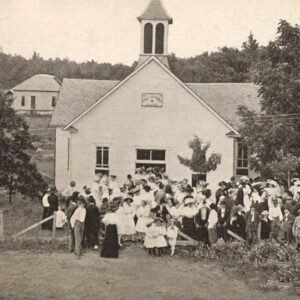 Garfield Church
 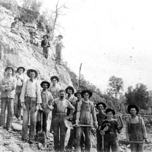 Garfield Lime Works
501-918-3025
calsfoundation@cals.org
calsfoundation@cals.org
| Latitude and Longitude: | 36°26’54″N 093°58’27″W |
| Elevation: | 1,489 feet |
| Area: | 3.09 square miles (2020 Census) |
| Population: | 593 (2020 Census) |
| Incorporation Date: | September 15, 1888 |
Historical Population as per the U.S. Census:
|
1810 |
1820 |
1830 |
1840 |
1850 |
1860 |
1870 |
1880 |
1890 |
1900 |
|
– |
– |
– |
– |
– |
– |
– |
– |
112 |
– |
|
1910 |
1920 |
1930 |
1940 |
1950 |
1960 |
1970 |
1980 |
1990 |
2000 |
|
– |
– |
– |
104 |
83 |
48 |
163 |
187 |
308 |
490 |
|
2010 |
2020 |
|
|
|
|
|
|
|
|
|
502 |
593 |
|
|
|
|
|
|
|
|
Garfield is a town in Benton County, located just east of the Pea Ridge National Military Park. Named for James Garfield, the twentieth president of the United States, the community first rose to prominence as a railroad depot used for shipping water and fruit. After years of decline following the Depression, the town revitalized in the late twentieth century with the growing population of the county.
The earliest settler at the location that would become Garfield was James Jackson, who arrived around 1839. Other families that settled in the area before the Civil War include those of Benjamin Mahurian, Joshua Brotcher, and Archibald Blansett. The Battle of Pea Ridge, fought March 7–8, 1862, near the present location of Garfield, was a decisive victory for the Union, helping to align Missouri with the northern states and providing an entryway into Arkansas.
Following the war, settlers slowly returned to the land, but the first major development that brought new residents was construction of the St. Louis–San Francisco Railway (commonly known as the “Frisco”) across Benton County in 1881. A depot was built at the highest point on the line in Benton County. The depot and the post office that opened at that location in 1881 were briefly named Blansett for the early settler, who was operating a general store at that location. In 1881, the name was changed to Crowell to honor postmaster Samuel Crowell. In 1883, a town was platted and lots auctioned to buyers. At that time, the Frisco asked that the depot be renamed, and the name of Garfield, to honor the assassinated president, was reportedly drawn from a hat. The post office did not change its name to Garfield until 1887.
By 1888, the growing community had several stores, a hotel, two blacksmith shops, a barber, and a Masonic lodge. A school met in the lower story of the lodge building. No churches had been built, but Christian and Baptist congregations met in private homes. A fruit evaporator was operating, as was a lumber yard and a lime works. The lime works employed seventy-five men, making their own barrels and shipping out 200 barrels of lime each day.
Locally grown apples and other fruits were shipped from the depot. Bottled water from Eureka Springs (Carroll County) was also transported to Garfield to be shipped on the Frisco line. By 1915, the town had added a milling company and a telephone company. Jess Whitney had the largest orchards in the area, growing apples and peaches. When orchard crops began to fail due to disease and other factors, some farmers switched to strawberries as their primary crop.
Clyde Taylor Ellis, who was born on a farm near Garfield, taught in the Garfield schools and became school superintendant in 1929. He also received a law degree and was elected to the Arkansas General Assembly. Ellis was a strong supporter of rural electrification and saw to it that his hometown was provided with electric power. He later served in the U.S. House of Representatives and was for many years an executive in the electric power industry.
The decline of the fruit industry in Benton County, coupled with the general hardships of the Depression, caused a significant decline in the population and business base of Garfield. Seven men from Garfield lost their lives fighting in World War II. By 1975, writers were describing Garfield as a town “on its way out.” However, the construction of Beaver Lake and Dam in nearby western Carroll County in the early 1960s signaled the beginning of a tourism industry for Garfield. Moreover, dramatic changes led to a population explosion in all of Benton County, with the population rising from 50,000 residents in 1970 to more than 200,000 in 2010. Executive offices of Walmart Stores, Inc., and J. B. Hunt Transport Services, Inc., are among the reasons for this dramatic change. Garfield benefited from the growth, as its population grew from only forty-eight residents in 1960 to 502 in 2010.
Among the approximately 130 businesses listed in Garfield in 2010 were tourist businesses associated with Beaver Lake, construction firms, automotive businesses, stores, and restaurants. Garfield has four churches: Baptist, Freewill Baptist, Assembly of God, and a Sons of Glory Ministry. The local elementary school, which is on the National Register of Historic Places, is part of the Rogers School District. Hamilton Park, a city park developed in 2010 and dedicated in 2011, is located alongside U.S. Highway 62.
For additional information:
Benton County Heritage Committee. History of Benton County, Arkansas. Rogers, AR: Benton County Heritage Committee, 1991.
Black, J. Dickson. History of Benton County. Little Rock: International Graphics Industries, 1975.
City of Garfield. https://www.garfield-arkansas.us/ (accessed June 3, 2022).
Mahurin, Wanda. The History of Garfield, Arkansas, 1874–1996. Ozark, MO: Dogwood Printing, 1996.
Ross, Dorothy Ellis. “Garfield, First Line on the Frisco.” Benton County Pioneer 29 (Summer 1984): 29–31.
Seamster, Alvin. “Garfield, Arkansas (Original Name, Crowell).” Benton County Pioneer 5 (March 1960): 28–29.
Steven Teske
Butler Center for Arkansas Studies


Comments
No comments on this entry yet.