 Environment
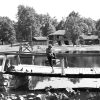 Recreation and Sports
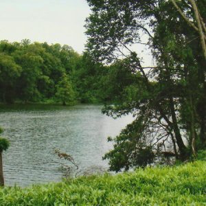 Ditch Bayou
 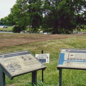 Ditch Bayou Marker
 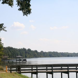 Lake Chicot State Park
 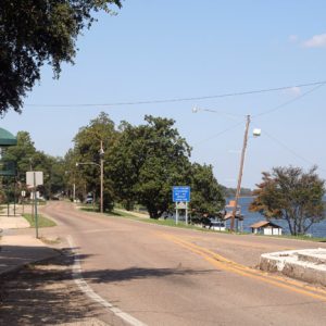 Lake Village
 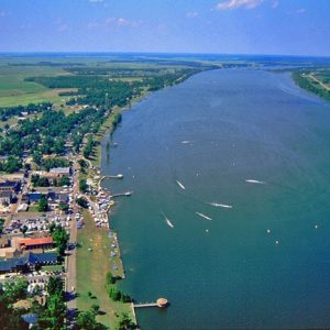 Lake Chicot
501-918-3025
calsfoundation@cals.org
calsfoundation@cals.org
Lake Chicot in Chicot County is both the largest oxbow lake in North America and the largest natural lake in the state of Arkansas, running almost twenty-two miles in a C-shaped curve one mile wide and covering 5,000 acres. The city of Lake Village (Chicot County) is situated along its western shore, while Lake Chicot State Park lies on its northern shore. The lake has been at the center of history and culture in Chicot County, serving as the site of a Civil War engagement and as a focal point for local plantation agriculture. Charles Lindbergh conducted his first night flight ever over Lake Chicot in 1923.
Geologists estimate that Lake Chicot likely separated from the Mississippi River several centuries ago when the river cut a shorter pathway to the east. The expedition of Hernando de Soto likely touched upon the site of the lake; after his death and burial near Lake Village, his body was exhumed and thrown into the Mississippi River. Many historians today believe that part of the river became Lake Chicot. However, the lake was given its name from later French explorers, being derived from a French word meaning “stump,” in reference to the many cypress knees that dot the lake shore.
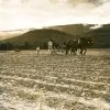
White settlement of the area began in the late 1820s. Before the Civil War, slave-driven agriculture flourished in the vicinity of Lake Chicot, originally called by American settlers “Old River Lake.” Most of the slaves worked on plantations situated in the vicinity of Lake Chicot, where they worked primarily on cotton. Sunnyside Plantation, to give one example, was founded in the 1830s on the inside of the C-shaped curve of the lake; in the 1890s, the plantation was the site of a large Italian immigrant community. In 1860, just before the Civil War, Chicot County slaves accounted for 7,512 of the total population of 9,234, or approximately eighty-one percent of the population. On June 6, 1864, Union and Confederate forces fought along the south shore of Lake Chicot in the Engagement at Old River Lake (also known as the Engagement at Ditch Bayou), the largest Civil War engagement to occur in the county and the last of any real significance in the state; Union forces succeeded in driving the Confederates away from the Mississippi River, thus making travel on the river relatively safer.
Until the 1920s, water from Lake Chicot was considered pure enough that the city of Lake Village used it untreated. However, that changed later in the decade as local work on the Mississippi River levee began. To prevent flooding behind the levee, Cypress Creek Gap, through which flowed drainage north of Lake Chicot to the Mississippi, was closed, and a new system of ditches and canals diverted drainage waters southward. In 1926–27, the local drainage district extended Connerly Bayou on the lake’s northern end to connect Lake Chicot with nearby Macon Lake, with drainage extended through Ditch Bayou on the lake’s southern end. The Flood of 1927 broke the dam on Connerly Bayou, which had formerly been preventing silt from pouring into the lake, thus leaving Lake Chicot as the collecting basin for a 350-square-mile watershed. The water level of the lake began to decline.
Pressured by the state attorney general, the local drainage district built a dam on Ditch Bayou in 1932 in an attempt to restore the lake to its normal level, but the dam washed out the following year. Beginning in the 1940s, increased clearing and cultivation of the surrounding watershed, combined with the growing use of pesticides on farmland, left the lower three-quarters of the lake south of where Connerly Bayou entered it a polluted and sediment-laden waste, its muddy brown water in dramatic contrast with the bright blue of the upper part of the lake, which was isolated by an earthen dam constructed by the Arkansas Game and Fish Commission (AGFC) in 1948 precisely to protect that portion of the lake. In 1956, a concrete dam was constructed across Ditch Bayou in order to maintain the lake’s water level, but there were continuing problems with mud and silt entering the lake. The lake’s bass population died out as a result. However, the waters on the protected northern quarter proved a regional attraction, resulting in the creation of Lake Chicot State Park on the northern shore in 1957.
In 1968, the AGFC, the U.S. Army Corps of Engineers, and the Chicot County Rural Development Authority came together to work on the Lake Chicot Project, an extensive plan to divert undesirable runoff around, not through, Lake Chicot. This project entailed the construction of a dam on Connerly Bayou, which had gates that opened or closed depending upon the quality of the water going through it, with overly polluted water being diverted to a pumping plant that would direct the water into Rowdy Bend, which flows into the Mississippi River. Obtaining the necessary funding for the project took some time, and the pumping plant was installed in 1985. That year, the Corps of Engineers drew down the lake to compact the sediment on the bottom and seeded the lake with plants that would provide a food base for fish populations. Game fish were restocked, and within a few years, the lake had largely recovered.
Lake Chicot is now home to bluegills, channel catfish, largemouth bass, hybrid striper bass, crappie, redear sunfish, and bream. Lying within the Mississippi Flyway, the lake also attracts migrating ducks and geese during the fall and winter, as well as ibises, egrets, and storks. It is a center for recreational opportunities in southeastern Arkansas, especially fishing and water sports, and there are homes built all around the lake.
For additional information:
Ritchie, Jerry C., Charles M. Cooper, J. Roger McHenry, and Frank R. Schiebe. “Sediment Accumulation in Lake Chicot, Arkansas.” Environmental Geology 5 (June 1983): 79–82.
Shea, William. “Battle at Ditch Bayou.” Arkansas Historical Quarterly 39 (Autumn 1980): 195–207.
Sutton, Keith. “The Death and Rebirth of Lake Chicot.” Arkansas Game and Fish 16 (September/October 1985): 5–9.
———. “Lake Chicot: A Natural State Natural.” Arkansas Game and Fish 22 (March/April 1989): 22–23.
Whayne, Jeannie M., ed. Shadows over Sunnyside: An Arkansas Plantation in Transition, 1830–1945. Fayetteville: University of Arkansas Press, 1993.
Staff of the CALS Encyclopedia of Arkansas


Comments
No comments on this entry yet.