501-918-3025
calsfoundation@cals.org
calsfoundation@cals.org
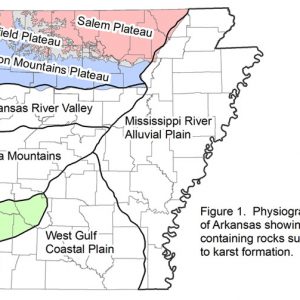
Karst topography refers to natural features produced on a land surface due to the chemical weathering or slow dissolving of limestone, dolostone, marble, or evaporite deposits such as halite and gypsum. The chemical weathering agent is slightly acidic groundwater that begins as rainwater. Rainwater becomes acidic by absorbing carbon dioxide to create carbonic acid as it falls through the atmosphere. It then passes through the soil horizon and, now acidic groundwater, moves through fractures (cracks) and open spaces within rocks. Solution occurs as carbonic acid in groundwater dissolves calcite, which is the principal mineral in limestone and marble and an important mineral in dolostone. Halite and gypsum are easily dissolved in water alone. The region in Arkansas most well known for karst topography is the Ozark Plateaus (sometimes called the Ozark Mountains).
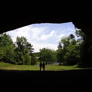
Features of karst landscapes include caves, springs, disappearing streams, dry valleys, and sinkholes. Acidic groundwater moves through fractures and spaces within the rock, slowly dissolving and enlarging spaces to create larger openings and connected passages. Caves occur as natural open spaces underground, generally with a connection to the surface and large enough for a person to enter. Underground passages allow groundwater to travel long distances and re-appear as springs. Springs occur where ground water flows naturally from a bedrock or soil onto the land surface or into a body of surface water. On the surface, a stream can disappear into the subsurface through fractures and passageways and travel underground for some distance before re-appearing downstream or discharging as a spring elsewhere. These streams are called disappearing streams. In areas where the stream is mostly dry year round, the valley is called a dry valley. Dry valleys are valleys devoid or almost devoid of running water and are common in areas underlain by carbonate rock with underground drainage. Sinkholes commonly occur as bowl- or funnel-shaped circular depressions and usually are the surface expression of underground drainage. Sinkholes form by solution, solution subsidence, and collapse. Solution sinkholes form as water infiltrates fractures in rock, dissolving and enlarging them. A gradual settling or lowering of the surface takes place, forming a depression. When carbonate rock is overlain by an insoluble rock such as sandstone, the underlying carbonate rock can undergo solution producing a void. This causes the overlying sandstone to subside into the void, producing solution subsidence sinkholes. Collapse sinkholes form when strata overlying a cave chamber collapse into the chamber.
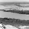
The majority of surface rocks in the Ozark Plateaus region of northern Arkansas are limestone and dolostone, and the region contains all of the features typical of a karst landscape. Thousands of caves and hundreds of springs are present in this region. Disappearing streams and dry valleys are common in the Salem and Springfield plateau regions. The Salem Plateau surface is primarily underlain by dolostone in the Everton, Cotter, and Powell formations. Located in this region is the largest spring in Arkansas—Mammoth Spring, with an average discharge rate of 118,500 gallons per minute. Solution sinkholes occur in dolostones in the Cotter, Powell, and Everton formations. Solution subsidence and collapse sinkholes are present where a thin veneer of the St. Peter Sandstone overlies the Everton Formation. Approximately twenty percent of the caves in Arkansas occur in this region. The Springfield Plateau surface is underlain by limestone in the Boone Formation. The Boone Formation contains the majority of karst features throughout the Ozark Plateaus region and contains more than fifty percent of the caves in the state. Solution and collapse sinkholes are abundant in the Boone Formation. Solution subsidence and collapse sinkholes are also present where a thin covering of Batesville Sandstone overlies the Boone Formation. The Joachim Dolostone and Plattin, Kimmswick, and Fernvale limestones are present along the escarpment between the Springfield and Salem plateau surfaces. Approximately five percent of the caves in Arkansas occur in these formations combined. The Boston Mountains Plateau surface consists of mostly sandstone and shale in the Atoka Formation, which is not susceptible to karst features. Approximately ten percent of the caves in the state occur in the Brentwood Limestone and the Prairie Grove Member of the Hale Formation in this region. In deep drainages and along the escarpment of the plateau, the Pitkin Limestone is present and contains hundreds of caves and springs.
A portion of the West Gulf Coastal Plain is underlain by thin beds of limestone, chalk, a variety of limestone, and gypsum. Numerous springs are present and one cave is reported from this region.
For additional information:
McFarland, J. D. “Number of Known Caves by County.” 1992. On file at Arkansas Geological Survey, Little Rock, Arkansas.
National Cave and Karst Research Institute. https://www.nckri.org/ (accessed February 15, 2022).
National Speleological Society. https://caves.org/ (accessed February 15, 2022).
Schrader, T. “Springs in Ozarks.” U.S. Geological Survey, 2010. On file at Arkansas Geological Survey, Little Rock, Arkansas.
“Sinkholes.” U.S. Geological Survey. https://www.usgs.gov/special-topics/water-science-school/science/sinkholes (accessed February 15, 2022).
Taylor, D. “Caves and Karst of Arkansas.” Association for Arkansas Cave Studies, 2009. On file at Arkansas Geological Survey, Little Rock, Arkansas.
Angela Chandler
Arkansas Geological Survey


Comments
No comments on this entry yet.