


501-918-3025
calsfoundation@cals.org
calsfoundation@cals.org
| Area: | 53,179 square miles (2020 Census) |
| Population: | 3,011,524 (2020 Census) |
| Capital: | Little Rock (Pulaski County) |
| Admitted to Union: | June 15, 1836 (Twenty-fifth state) |
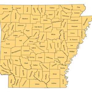
| Number of counties: | 75 |
| Governor: | Sarah Huckabee Sanders (Republican) |
| Lieutenant Governor: | Leslie Rutledge (Republican) |
| Secretary of State: | John Thurston (Republican) |
| Attorney General: | Tim Griffin (Republican) |
| Auditor: | Dennis Milligan (Republican) |
| Land Commissioner: | Tommy Land (Republican) |
| Treasurer: | Larry Walther (Republican) |
| U.S. Senators: | John Boozman (Republican), Tom Cotton (Republican) |
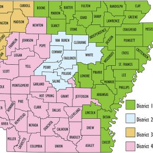
| U.S. Representatives: | Rick Crawford (Republican, First Congressional District), French Hill (Republican, Second Congressional District), Steve Womack (Republican, Third Congressional District), Bruce Westerman (Republican, Fourth Congressional District) |
Historical Population as per the U.S. Census:
| 1810: | 1,062 |
| 1820: | 14,255 |
| 1830: | 30,388 |
| 1840: | 97,754 |
| 1850: | 209,897 |
| 1860: | 435,450 |
| 1870: | 484,471 |
| 1880: | 802,525 |
| 1890: | 1,128,179 |
| 1900: | 1,311,564 |
| 1910: | 1,574,449 |
| 1920: | 1,752,204 |
| 1930: | 1,854,482 |
| 1940: | 1,949,387 |
| 1950: | 1,909,511 |
| 1960: | 1,786,272 |
| 1970: | 1,923,295 |
| 1980: | 2,286,357 |
| 1990: | 2,350,725 |
| 2000: | 2,673,400 |
| 2010: | 2,915,918 |
| 2020: | 3,011,524 |
| State Anthem: | “Arkansas” by Eva Ware Barnett |
| State Beverage: | Milk |
| State Bird: | Mockingbird |
| State Butterfly: | Diana Fritillary |
| State Dinosaur: | Arkansaurus fridayi |
| State Dog: | Labrador retriever |
| State Duck: | Mallard |
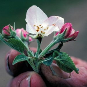
| State Flower: | Apple Blossom |
| State Folk Dance: | Square Dance |
| State Fruit and Vegetable: | South Arkansas Vine Ripe Pink Tomato |
| State Gem: | Diamond |
| State Grain: | Rice |
| State Grape: | Cynthiana |
| State Historic Cooking Vessel: | Dutch Oven |
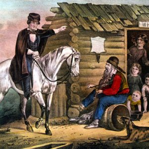
| State Historical Song: | “The Arkansas Traveler” by Sanford Faulkner |
| State Insect: | Honeybee |
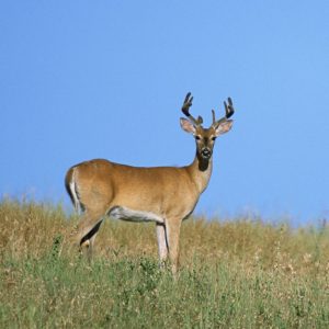
| State Mammal: | White-tailed Deer |
| State Mineral: | Quartz |
| State Motto: | “Regnat Populus” (The People Rule) |
| State Musical Instrument: | Fiddle |
| State Nickname: | The Natural State |
| State Nut: | Pecan |
| State Rock: | Bauxite |
| State Soil: | Stuttgart Soil Series |
| State Songs: | “Arkansas (You Run Deep in Me)” by Wayland Holyfield and “Oh, Arkansas” by Terry Rose and Gary Klass |
| State Tree: | Pine |
| Arkansas State Flag: | Arkansas’s state flag is a field of red upon which is a diamond surrounded by a band of blue, thus using all three colors of the United States flag. The diamond acknowledges Arkansas’s significance as a domestic source of the gems. On the band of blue are twenty-five stars that represent Arkansas’s place as the twenty-fifth state in the Union. In the middle of the diamond is the name of the state surrounded by four blue stars, representing the four countries whose flags have flown over Arkansas: France, Spain, the United States, and the Confederate States of America. |
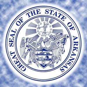
| Arkansas State Seal | The official state seal centers upon the image of an eagle holding a scroll in its beak bearing the words Regnat Populus (Latin for “the people rule”). The eagle holds a bundle of arrows in one claw and an olive branch in the other. A shield covering the breast of the eagle bears the image of a steamboat, beehive, plow, and sheaf of wheat. The Goddess of Liberty is above the eagle, circled by stars. An angel inscribed with the word “Mercy” is on the left of the bird, while a sword inscribed with the word “Justice” is on the right. |
| White (non-Hispanic): |
2,114,512 |
70.2% |
| Black or African American: |
453,783 |
15.1% |
| Hispanic or Latino: |
256,847 |
8.5% |
| Asian: |
51,839 |
1.7% |
| American Indian/Alaska Native: |
27,177 |
0.9% |
| Native Hawaiian and Other Pacific Islander: |
14,533 |
0.5% |
| Some Other Race: |
136,105 |
4.5% |
| Two or More Races: |
213,575 |
7.1% |
More detailed statistics on Arkansas’s population can be found here.
Pre-European Exploration, Prehistory through 1540
Archaeological evidence shows that what is now Arkansas was first inhabited around 11,500 BC during what is now called the Paleoindian Period. What is known about the people who lived in this and subsequent prehistoric periods is limited to what has been recovered from archaeological excavations—tools, pottery, animal bones, and garbage deposits. During the Archaic Period, the practice of mound building emerged, and some mound complexes in Arkansas testify to the sophistication of ancient native peoples. By the Mississippian Period, Indian groups in Arkansas had developed extensive agricultural practices, large villages, and long-distance trade routes.
European Exploration and Settlement, 1541 through 1802
The Spanish explorer Hernando de Soto led his expedition into Arkansas in 1541, at the end of the Mississippian Period. Though the de Soto expedition provided the first written accounts of the various Indian groups in Arkansas, it also spread disease and engaged in brutal attacks upon the populace, changing forever the face of Arkansas. The next Europeans to venture into Arkansas were Father Jacques Marquette and Louis Joliet, who, coming 130 years after de Soto, helped to establish peaceful relations with the Quapaw. The founding of Arkansas Post in 1686 provided a center for military action and trade in the region for France (and later Spain) for over a century, but large-scale colonization of Arkansas never occurred.
Louisiana Purchase through Early Statehood, 1803 through 1860
By the time the United States took possession of what is now Arkansas in 1804 as part of the Louisiana Purchase, the Native American population had been diminished due to disease and conflict, and there were few European-born inhabitants in the area. However, the population soon exploded as white Americans from the east and the north sought out the potential of the frontier (some bringing their slaves with them). It was during these days of its territorial period and early in its statehood that Arkansas acquired a reputation as a violent and lawless place run by a handful of crooked men, even as talented and industrious individuals such as William E. Woodruff and Albert Pike settled in Arkansas. Also during this period, Arkansas became the frontier of the cotton kingdom of the South, and as these cotton plantations depended upon the labor of enslaved people, the state’s place in the Union would be called into question.
Civil War through Reconstruction, 1861 through 1874
By February 1, 1861, seven Deep South states had seceded from the United States and formed the Confederate States of America, but Arkansas did not secede until May 1861. Though most Arkansans supported secession, a significant number, especially in the north-central region of the state, opposed it and resisted Confederate authority. The first full year of war seriously disrupted life in the state, especially after Union victories at Pea Ridge and Prairie Grove, and after Little Rock itself fell in September 1863. Arkansas was readmitted to the Union in 1868 with Republicans in charge of all levels of government. Reconstruction provided the state’s former slaves their first real political power, and many African Americans rose to high positions of authority within state government and civic organizations. However, resistance to these reforms resulted in a violent insurgency led by the Ku Klux Klan. Ultimately, the promise of Reconstruction faded with the 1872 election of Elisha Baxter as governor; though he was briefly deposed during the Brooks-Baxter War of 1874, his governorship heralded the return to power of the antebellum elites and the Democratic Party.
Post Reconstruction through the Gilded Age, 1875 through 1900
Arkansas was late in joining the “New South,” with its emphasis upon manufacturing rather than traditional agriculture, but it did eventually work at shifting gears that direction. By the end of Reconstruction, railroads connected many Arkansas cities to major cities of the South and beyond, opening up markets for Arkansas goods and allowing for the exploitation of the state’s natural resources, just as they brought new manufactured goods into Arkansas. The timber and mining industries thrived, while farmers, now competing with farmers across the nation, suffered a decline in prices. In response, real threats to the Gilded Age Democratic hegemony emerged in the form of the Greenback Party and the Agricultural Wheel, which capitalized on farmers’ discontent with governmental policies. To combat this new threat, the Democratic-controlled state legislature passed a number of laws that essentially stripped the supporters of these movements of the right to vote. Those in control brought about a new era of legal and social segregation to prevent a rising Black middle class from achieving its share of influence.
Early Twentieth Century, 1901 through 1940
The early twentieth century was a time of increasing progressivism for Arkansas. The Woman’s Christian Temperance Union worked to get a prohibition measure passed in 1917. That same year, the state legislature voted to let women participate in the Democratic primary, making Arkansas the second state in the Union to approve women’s suffrage. The state began reforming its education system and, during the tenure of Governor George Donaghey, established four agricultural schools that eventually became universities. All was not bright, however. White rioters in Harrison (Boone County) drove African Americans out of town, and white planters and soldiers murdered an unknown number, possibly hundreds, of Black sharecroppers and tenant farmers in and around Elaine (Phillips County). The Flood of 1927 brought ruination to much of the Delta farmland, creating a situation that the subsequent Great Depression only exacerbated. However, from this milieu of oppression and poverty arose the integrated Southern Tenant Farmers’ Union, which, despite being short-lived, foreshadowed the civil rights movement of the mid-twentieth century.
World War II through the Faubus Era, 1941 through 1967
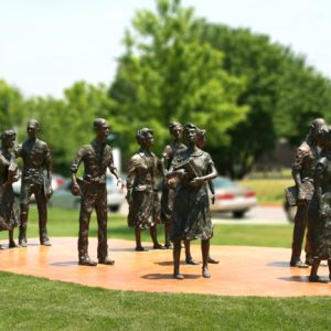
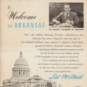
Many men and women from Arkansas signed up for military service at the dawn of World War II, and many others took jobs in the new ordnance plants established within the state; these plants continued the industrialization of Arkansas, which had been interrupted by the Depression. But these few new industries could not satisfy the employment needs of all Arkansans, and many left the state in search of jobs elsewhere. Among those emigrating were many African Americans who had been left out of the economic uplift and who resisted being forced to stay on the farms to sharecrop. In the largest in-migration of any ethnic group to the state, some 16,000 Japanese Americans were interned in two relocation camps in the state from October 1942 to November 1945. In 1948, Arkansas voters elected progressive and racial moderate Sid McMath as governor, but the state’s image was to be tarnished by a later governor, Orval Faubus, whose resistance to the desegregation of Little Rock (Pulaski County) schools created a national crisis and made Arkansas a byword for racism. Though he was elected more times than any Arkansas governor, he was succeeded by Winthrop Rockefeller, the first Republican to hold the office since Reconstruction. Rockefeller’s election signified a return to racial moderation and a determination to improve the state’s image and attract more business and industry.
Divergent Prosperity and the Arc of Reform, 1968 through 2022
Rockefeller led reforms in many areas of state government, most notably its prison system, and his immediate successors—Dale Bumpers, David Pryor, and Bill Clinton—though all Democrats, led in a similar vein, working to modernize Arkansas. During this time, the economy of northwestern Arkansas grew exponentially with the rise of businesses such as Walmart Inc. and Tyson Foods, even as the former powerhouse of the state, the Arkansas Delta, fell into poverty. The state modernized and became more urban—with cities such as Fayetteville (Washington County), Rogers (Benton County), Little Rock (Pulaski County), and Jonesboro (Craighead County) growing at a fast clip—but women and minorities remained underrepresented in the upper echelons of political and economic power. Beginning in the 1980s, the state became increasingly conservative both politically and culturally. Republican Frank White was elected governor in the 1980 election, splitting Clinton’s tenure as governor, and Baptist preacher Mike Huckabee, sworn in as governor in 1996, was elected twice, in 1998 and 2002. Until the 2012 election produced a Republican majority in the state legislature for the first time since Reconstruction, Arkansas remained predominately Democratic even as it tended to vote Republican in presidential elections. Clinton’s election to the presidency in 1992 made many Arkansans feel that their state had “come of age” and finally had a place in national politics. Democrat Mike Beebe was elected Arkansas’s governor in 2006. Republican Asa Hutchinson was elected governor in 2014, as Arkansas became a solidly Republican state, and by the time Hutchinson left office, the state’s Republican Party had secured every constitutional office and a supermajority in both houses of the legislature. Republican Sarah Huckabee Sanders was elected governor in 2022.
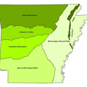
Six Natural Divisions:
Arkansas geography is best understood in terms of its six natural divisions. They are as follows:
Ozark Plateau (a.k.a. Ozark Mountains): The Ozark Plateau extends across northern Arkansas from Washington and Benton counties in the west to Batesville (Independence County) in the east, extending into eastern Oklahoma and southern Missouri as well. The domed plateaus (i.e., “mountains”) were uplifted in the Paleozoic era from the geologic pressure that continental plates exerted upon each other; in many places, rivers cut valleys through the Ozark Plateau. This area was sparsely settled before Europeans began filtering into present-day Arkansas, and it kept a comparatively low population long after the state entered the Union. Plantation slavery never extended into the area, and this, combined with a sense of independence bred by rural isolation, made the Ozark Plateau a hotbed of pro-Union sentiment during the Civil War. Save for the phenomenal growth of cities in Washington and Benton counties, much of the area remains predominantly rural, though it does draw tourists looking to experience the Ozark National Forest, the Buffalo National River, or any of the manmade lakes that dot northern Arkansas.
Ouachita Mountains: Geologic pressure also resulted in the continental folds called the Ouachita Mountains, which extend from the vicinity of Little Rock into eastern Oklahoma. In some areas, heat from geologic forces created formations of crystal and novaculite, the latter being a rock unique to Arkansas. Save for Little Rock, this area, too, has been sparsely settled over time, though today, many tourists are drawn to the Ouachita National Forest and the city of Hot Springs (Garland County), named after the hot springs located there, which are the result of the heating of groundwater far below the earth’s surface.
Arkansas Valley (a.k.a. Arkansas River Valley): This area is located between the Ozark Plateau and the Ouachita Mountains and extends eastward into Oklahoma, following the Arkansas River. It was the site of shallow swamps during the Paleozoic era, but these swamps slowly disappeared as the land on either side of the Arkansas Valley rose and the organic material within was eventually transformed into coal and natural gas. Throughout the human habitation of Arkansas, the Arkansas Valley has been a prime spot for settlement due to the abundance of water and other natural resources. Part of the valley today is known as Arkansas’s wine country on account of nineteenth-century German immigrants establishing vineyards in this area much like their homeland. The cities of Fort Smith (Sebastian County), Clarksville (Johnson County), Russellville (Pope County), and Conway (Faulkner County) lie in the Arkansas River Valley.
West Gulf Coastal Plain: Lying beneath the Gulf of Mexico until the Cenozoic era, the West Gulf Coastal Plain is made up of sand and gravel that has, over time, been cemented into hard rock. The plain takes up most of southern Arkansas and extends into Oklahoma, Texas, and Louisiana. Before European exploration, this area was home to, most notably, the Caddo Indians, who were noted for their mound building. The area remains noted for its geology, as it encompasses the only diamond mine in North America, located at Murfreesboro (Pike County), as well as the center of the state’s oil industry, located in Union County. The Gulf Coastal Plain is also the focus of much of the timber industry in Arkansas.
Mississippi Alluvial Plain (a.k.a. Arkansas Delta): Virtually the entire eastern third of Arkansas is encompassed by the Mississippi Alluvial Plain, which is made up of the alluvial deposits left behind by the Mississippi River throughout the ages. This area was home to many prehistoric Native American habitations, including a ceremonial complex now known as the Toltec Mounds site and the small village of the leader Casqui, which was visited by the Hernando de Soto expedition. At the start of larger-scale European exploration in the seventeenth century, the Quapaw inhabited parts of the Mississippi Alluvial Plain, and Arkansas’s first territorial capital was located at Arkansas Post, though it had to be moved farther inland due to flood and disease. Much of the land was swamp that was cleared of its hardwood timber and drained to make the cotton and bean fields prevalent today. Until Arkansas became firmly committed to industrialization, in the early to middle twentieth century, this part of the state was its economic powerhouse, dotted with plantations that, in antebellum days, were worked by large numbers of slaves and, later, before the advent of mechanized agriculture, were worked mostly by sharecroppers and tenant farmers. Though it still remains the center for the state’s large-scale agriculture, changes in the economy have left the region impoverished.
Crowley’s Ridge: Crowley’s Ridge is a strip of land anywhere from five to twenty miles wide and extending about 150 miles from southeastern Missouri to Helena-West Helena (Phillips County). Completely surrounded by the Mississippi Alluvial Plain, it is a strip of higher ground (generally less than 200 feet above the surrounding Delta land) that was formed during the most recent glacial advance, when the rivers reworking eastern Arkansas left it untouched. Named after explorer Benjamin Crowley, the ridge has historically been a refuge from the floods that frequently plagued the land, and all those counties through which the ridge passes have their seats of government located upon the high ground. The most populous city in east Arkansas, Jonesboro (Craighead County), is located along the ridge.


Comments
No comments on this entry yet.