 River Designations
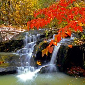 Cossatot River State Park
 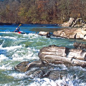 Cossatot River
  Cossatot Visitors Center
 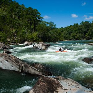 Cossatot River
 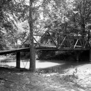 Cossatot River Bridge
 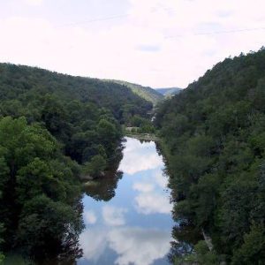 Cossatot River State Park - Natural Area
 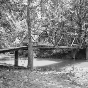 Little Cossatot River Bridge
501-918-3025
calsfoundation@cals.org
calsfoundation@cals.org
The Cossatot River rises in the Ouachita Mountains southeast of Mena (Polk County) and flows southward through Howard County and Sevier County before emptying into the Little River north of Ashdown (Little River County). The upper portion of the river is well known as a whitewater stream and is popular among canoeists and kayakers. The Cossatot River is dammed in Howard County by Gillham Dam.
The area around the Cossatot River has been the site of human habitation since approximately 10,000 BC, and there have been Indian mounds located along the course of the river. In the historic period, the Caddo Indians lived in the corner of Arkansas through which the Cossatot flows, though they were coerced into signing away their lands in 1835. Some sources claim that the name of the river comes from an Indian term meaning “skull crusher,” but the term is actually French, cassé-tête (literally, “crushed head”). The name is probably due to the severity of the rapids in the upper part of the river. Local legend holds that Spanish explorers discovered gold and operated mines along the river, though no evidence exists of such.
The area along the Cossatot River, especially in the Ouachita Mountains, remained sparsely populated until the twentieth century. The hills were not amenable to large-scale agriculture, and only the southern portion of the river below an area dubbed Three Chutes proved useful for transportation, though the stream would on occasion dry up. Robert C. Gilliam did establish a plantation along on the Cossatot River after moving to the region in the 1830s. In the mid-1800s, antimony deposits were discovered along the river, though they were not exploited until the 1870s; this mining activity was concentrated in the town of Antimony City (Sevier County) and continued until the early twentieth century. Between 1898 and 1901, a grist mill was constructed at Three Chutes. In 1899, the Ultima Thule Highway was constructed across the river in the same region.
The Flood Control Act of 1958 authorized the construction of Gillham Dam for purposes of flood control and to provide a steady water supply to surrounding communities; the dam takes its name from the nearby town of Gillham (Sevier County). It was sixty percent completed when a coalition of environmental groups—the Ozark Society, Environmental Defense Fund, Arkansas Audubon Society, and Arkansas Ecology Center—filed suit on October 1, 1970, to stop the project, claiming that the dam would take away the last free-flowing and wild river in southwest Arkansas. The coalition also argued that the U.S. Army Corps of Engineers had submitted an insufficient environmental impact statement. In February 1971, Federal Judge G. Thomas Eisele ruled that the Corps had not sufficiently examined ecological consequences as required by law. After the Corps resubmitted its environmental impact statement, Judge Eisele, on May 5, 1972, removed the injunction against further construction on the dam. Work resumed in August 1972. Further appeals against the dam were fruitless, and the dam’s reservoir began filling in May 1975.
The Cossatot River State Park-Natural Area was established along the river in Polk and Howard counties in 1988. Twenty-six miles of the river north of Gillham Lake are part of the Arkansas Natural and Scenic Rivers System. In the early 1990s, 26.6 miles of the river were federally designated as “scenic,” with another 4.2 designated as “recreational.” The river also forms the western border of the Howard County Wildlife Management Area. Some of the more famous waterfalls along the river are Seven Falls, Sheep’s Den, and Cossatot Falls.
For additional information:
Approved Jurisdictional Determination Form. U.S. Army Corps of Engineers, Little Rock District. https://www.swl.usace.army.mil/Portals/50/docs/regulatory/Approved%20JDs/Aug-2016/AR/SWL%202016
-00258%20AJD.pdf (accessed February 15, 2022).
McCommas, Betty. The History of Sevier County and Her People. Dallas, TX: Taylor Publishing Company, 1980.
Pond Creek National Wildlife Refuge. U.S. Fish and Wildlife Service. https://www.fws.gov/southeast/planning/PDFdocuments/PondCreekFinalCCP/CCP%20Body%20
Final%20Pnd%20Crk.pdf (accessed February 15, 2022).
Robinson, Bob. “White Knuckles, White Water.” Arkansas Democrat-Gazette, May 18, 2020, pp. 1D, 6D.
Staff of the CALS Encyclopedia of Arkansas


I live 10 min. from the river and it is one of the cleanest, finest small rivers in the world. The deeper holes are cool in summer months. Fish gather at your feet in seconds. I have almost 40 acres and two old homes .My taxes are 350 bucks a year. Eat your heart out, and enjoy your gated community.