 Salmonids
 Dam Protesters
 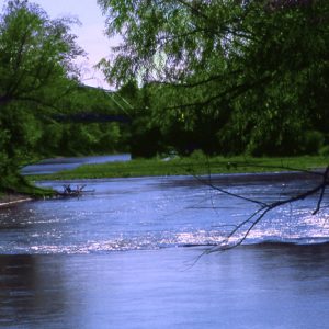 Eleven Point River
 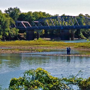 Eleven Point River
501-918-3025
calsfoundation@cals.org
calsfoundation@cals.org
The Eleven Point River rises in the Ozark Mountains of Missouri near the town of Willow Springs and flows south-southeast, passing through the Mark Twain National Forest and entering Arkansas in Randolph County. It empties into the Spring River west of what is now Davidsonville Historic State Park and lends its name to the town of Eleven Point (Randolph County).
The part of the Ozark Plateau through which the Eleven Point River flows was home to human habitation approximately as long ago as 10,000 B.C., according to archaeological excavations near Greer Springs, which empties into the Eleven Point. In addition, a few Indian mounds dating from the Mississippian Period have been located in the valley of the Eleven Point. In historic times, the Osage Indians claimed much of southern Missouri and northern Arkansas, including the watershed of the Eleven Point River, though they were forced to relinquish such claims in 1825. French trappers operated in the area in the eighteenth century, and indeed the Eleven Point River receives its name from the French word pointe, used by early explorers to indicate the point of land marking a bend in the river; this was a way of marking distance. Like the Current River, the Eleven Point is fed by numerous springs, which keep the river’s level fairly constant throughout the year.
As elsewhere in the Ozark Mountains, the Eleven Point River valley was the site of extensive logging operations during the late nineteenth and early twentieth centuries. The Civilian Conservation Corps (CCC) undertook some reforestation projects in the area in the 1930s.
The Flood Control Act of 1938 authorized the Water Valley Dam and Reservoir project on the Eleven Point River in Arkansas, but many area residents opposed damming the river, and the project was temporarily put on hold. The U.S. Army Corps of Engineers (USACE) again considered damming the river in 1954 in order to provide flood control as well as hydroelectricity, but the river was later determined to be unsuitable for hydroelectricity generation. Previously, President Harry S. Truman had established the Arkansas-Red-White River Basin Interagency Committee to undertake a flood-control survey for the larger region. The committee released a study in 1954 recommending that the Eleven Point River and the Current River, which also flows through Missouri and Arkansas, be preserved in their natural state. Despite this, the U.S. Congress appropriated money for the USACE to study the river once again, and local residents organized under the Upper Eleven Point River Association to oppose damming. In April 1965, the USACE recommended that the proposed dam be de-authorized.
In 1959, the Missouri House of Representatives passed a resolution asking the U.S. Congress to establish a national recreation area along the banks of both the Eleven Point and Current rivers, and a subsequent study recommended turning part of the watershed into a national monument. Many landowners opposed the move, and when the federal government established the Ozark National Scenic Riverways in 1964, it excluded the Eleven Point River from protection. However, a forty-four-mile stretch of the river in southern Missouri was set aside for preservation purposed by the U.S. Congress in 1968, becoming the Eleven Point National Wild and Scenic River.
Like many other Ozark rivers, the Eleven Point is popular with canoeists and fishers. The river is home to smallmouth bass, rock bass, walleye, and trout.
For additional information:
Eleven Point Wild and Scenic River. https://www.fs.usda.gov/recarea/mtnf/recarea/?recid=21676 (accessed February 15, 2022).
“Engineers Recommend End to Project on Eleven Point.” Arkansas Gazette. April 23, 1965, p. 11A.
Staff of the CALS Encyclopedia of Arkansas


My great-great-grandfather “Lum” Johnson operated a ferry in Johnson’s Ferry, Missouri, until a bridge was built around 1905, now called Riverton.