 King's River, Skirmish at
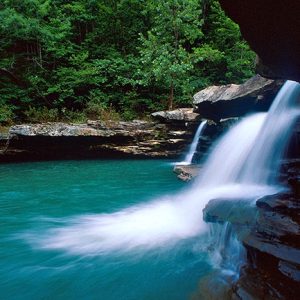 Kings River
 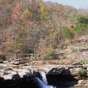 Kings River Falls Natural Area
 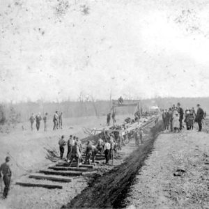 Laying Track in Carroll County
501-918-3025
calsfoundation@cals.org
calsfoundation@cals.org
The Kings River runs for about ninety miles through Madison and Carroll counties to its confluence with the White River arm of Table Rock Lake, located on the Missouri–Arkansas border. As with other rivers that begin on the north-facing slopes of the Boston Mountains, the Kings River flows north. The river divides Carroll County politically; in 1883, the Arkansas legislature recognized two judicial districts, at Berryville (Carroll County) and Eureka Springs (Carroll County), on opposite sides of the river, though the river itself was not the legal boundary until 2011.
The Kings River drains from two very different subsections of the Ozarks. Its headwaters form in the oak forests of the Boston Mountains sub-region of the Ozark Plateau near the community of Boston (Madison County). Topographical relief in this area is as much as 1,000 feet, and terrain and stream gradients are steep and rugged. The stream cuts through late Mississippian and Pennsylvanian age sandstone, shale, and some limestone. The river begins to form on the north side of the dividing east-west ridge within about a ten-mile radius of the headwaters of other important Ozark rivers, including the White, War Eagle, and Buffalo rivers. The middle and lower segments of the Kings mostly drain portions of the Springfield Plateau sub-region. Topographical relief here rarely exceeds 300 feet and is characterized by rolling hills with localized ridges and bluffs, oak woodlands, and some prairie. The underlying geology of this plateau is composed of dolomite, limestone, and chert of the older Mississippian age. Karst features—including water-bearing fractures, caves, and sinkholes from the dissolving dolomite and limestone—are common.
One of the first men of European ancestry to reach the Kings River was Henry King from Alabama. King, Thomas Cunningham, and John J. Coulter made a prospecting expedition into the Boston Mountains in the summer and fall of 1827. Accounts differ as to King’s death, but Goodspeed’s history states that King is buried on the bank of the river that now allegedly bears his name. However, there is reference to the Kings River in the February 4, 1823, issue of the Arkansas Gazette, thus calling into question the popular story behind the origin of its name. Other families from Alabama, including Kings, also subsequently settled in the area. Place names such as Madison County, Huntsville (Madison County), Kingston (Madison County), and Alabam (Madison County) also bear witness to early settlers from Alabama.
From the 1830s to the early twentieth century, European settlers dramatically altered forests through land clearing and timber harvesting, resulting in a decline of forested land. Native Americans used fire to control lower understory brush. A more open understory made game easier to hunt and controlled pests like ticks. Suppression of fire over the years increased understory brush. Changes and decline were accelerated beginning around 1940 when the poultry industry started to replace traditional subsistence farms. More river corridor land was cleared to build poultry houses and to make room for cattle and hay pastures, which helped to supplement poultry farmers’ incomes.
By 1951, the U.S. Army Corps of Engineers had begun to make plans to dam the river near Grandview (Carroll County) as part of flood-control efforts on the White River and tributaries, but a dam has never been constructed. Conservation gains over the years have written a different fate for the river.
Currently, the Kings River is recognized as an Extraordinary Resource Waterbody by the state of Arkansas. This designation places restrictions on streambed alterations and gravel mining and increases pollution monitoring and standards. The Arkansas Natural Heritage Commission also maintains a natural area at the Kings River Falls. In 2010, the Nature Conservancy purchased the Kings River Preserve—approximately 5,000 acres, including seven miles of river frontage near Berryville. The preserve is home to more than thirty endemic Ozark species, including one or two stonefly species that are globally rare. Part of this middle section of the river is also managed by the Arkansas Game and Fish Commission as a trophy smallmouth stream. Canoe float trips and fishing have become popular pastimes on the river. The 14,227-acre McIlroy Wildlife Management area lies just west of the Kings halfway between Huntsville and Eureka Springs. It provides hunting opportunities and helps protect many tributary streams which flow into the Kings.
For additional information:
Adamski, J. C., J. C. Peterson, D. A. Friewald, and J. V. Davis. Environmental and Hydrologic Setting of the Ozark Plateaus Study Unit, Arkansas, Kansas, Missouri, and Oklaholma. Little Rock: Government Printing Office, 1995.
Allen, Doug “Riverman.” The Riverman’s Guide to the King’s River. Fayetteville, AR: 2021.
Deane, Ernie. Arkansas Place Names. Branson, MO: The Ozarks Mountaineer, 1986.
Garrett, Chance Douglas. “Influence of Natural Flow Regine on Fish Communities of Four Streams in the Kings River Watershed, Arkansas.” MS thesis, University of Central Arkansas, 2022.
History of Benton, Washington, Carroll, Madison, Crawford, Franklin, and Sebastian Counties, Arkansas. Chicago: Goodspeed Publishing Co., 1889.
Wallworth, Adam. “7-mile Stretch of Kings River to be Preserved.” Arkansas Democrat-Gazette. March 27, 2010, pp. 1B, 3B.
Scott Branyan
Rogers, Arkansas


Comments
No comments on this entry yet.