 French Explorers and Settlers
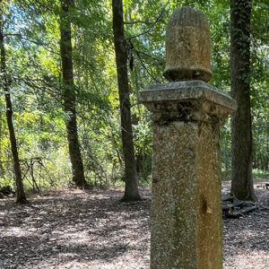 Cumby Grave
 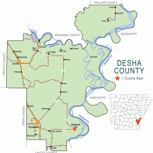 Desha County Map
501-918-3025
calsfoundation@cals.org
calsfoundation@cals.org
Big Island in Desha County was once the largest island in the continental United States. It is bordered on the east by the Mississippi River. The northern boundary is formed by the White River and the new channel of the Arkansas River, and the western and southern boundaries are formed by the old channel of the Arkansas River. The island is indicated on some maps as “Big Island,” while others—including U.S. Army Corps of Engineers maps—show it as “Montgomery Island,” named after William Montgomery, a prominent early settler in the area.
Big Island is about eleven miles long and seven miles wide. However, the meanderings of the three rivers have caused many changes in the appearance of the island over the historical record. In fact, the island is smaller than it once was, despite the occasional deposits of soil from floods. The fifth principal meridian extends north and south through the island and creates the division line between Ranges One East and One West. The primarily flat elevation is an average of 148 feet above sea level. Its exceptionally fertile soil is well-drained, except for the occasional floods. The island consists of approximately 25,000 to 30,000 acres. Four lakes—Moore, Pelican, Swan, and Deer—are located on the island, as is Knowlton Bayou.
The Quapaw inhabited what would be called Big Island when René-Robert Cavelier, Sieur de La Salle first went down the Mississippi River in 1673. However, it was not the Quapaw who built the mounds once located there. All traces of native habitation have been erased by time and water. Non-native settlers came early to Big Island because of its prominence along the three major rivers—the White, Mississippi, and Arkansas—which served as the means of transportation of the day. Early settlements on the north side of the island were Cumbyville, Mouth of the White River/White River Landing, and Montgomery Landing/Montgomery Point. Steamboats once landed at Big Island, and ferry service plied both north and south of the island, and also across the river to Rosedale, Mississippi. On Big Island, shippers had to unload freight from the larger steamboats that plied the Mississippi onto smaller steamboats before entering the White and Arkansas rivers.
When Desha County was formed in December 1838, Big Island was sufficiently populated to form its own township, Island Township. Over time, however, the township was absorbed into Red Fork Township. Big Island was populated and developed by large-scale farmers whose main crops were cotton and corn. There was also at least one cotton gin in operation.
Big Island was important during the Civil War. Desha County and Big Island had no permanent Confederate troops for defense, but soldiers from Texas tried to prevent the Union from invading Texas by way of Arkansas. Before the Union took control of the island late in 1862, Confederates used the island for smuggling, scouting, and transporting military supplies bound for Vicksburg, Mississippi. General John A. McClernand quickly saw the potential of the location, for he requested to General Ulysses S. Grant that the location be substituted as a principal garrison instead of Helena (Phillips County). Once the Union controlled the area, Big Island became a haven for runaway slaves, who came in droves. Some remained after the war and became planters.
Cattle roamed freely on Big Island. During World War II, Andrew Wargo, whose family had established a farm in the area, contracted with the government to raise cattle for the army. Wild hogs also roamed freely on Big Island; they were a good food source but could be dangerous. In the summer, if the water in the Arkansas River was low, cattle could be forded at a small place on the south end of the island.
Flooding along the rivers was a constant challenge to the ingenuity of the residents, who constructed large rafts of floating logs to transport their livestock to safety. These barge rafts would be kept for future floods.
There were three cemeteries on the island. A large cemetery was located near the populated northern part of the island, and another one was located near Moore Lake at the middle of the island. The third cemetery caved into the Mississippi River. Only two grave markers remain visible on the island; one belongs to planter William S. Cumby.
Farming in Desha County could not occur on a massive scale until the levee on the Arkansas River was built to prevent floods. However, its construction doomed farming on Big Island, as flood waters that would have spread over a large part of the county were concentrated on Big Island, located on the river side of the levee. Over time, many of the island’s residents sold their land. Many more lost their land due to tax forfeiture or mortgage foreclosures, while some just simply abandoned the island. Big Island soon returned to a state of nature.
There are no public lands or roads on Big Island. The land is primarily owned by large timber companies and leased to various private hunting clubs. The island abounds with wildlife and lakes teem with fish. Access to the island was always via boat until the construction of Norrell Lock and Dam, the first lock and dam of the McClellan-Kerr Arkansas River Navigation System. When the dam project was completed in 1967 on the new channel of the Arkansas River, a public Arkansas County Road was built to the dam on Big Island’s northern tip. Some hunting camps have access to landing strips for small aircraft.
For additional information:
“Big Island.” Programs of the Desha County Historical Society 23 (2009): 7–13.
“Big Island Was Once Thriving Settlement.” Programs of the Desha County Historical Society 1 (1973): 29–34.
Staudinger, Chris, Mark Peoples, and John Ruskey. “Where Three Rivers Meet.” Arkansas Times, June 20, 2013, pp. 12–17. Online at http://www.arktimes.com/arkansas/exploring-big-island-where-three-rivers-meet/Content?oid=2928547 (accessed October 13, 2021).
Helen Pennington
Pine Bluff, Arkansas


Comments
No comments on this entry yet.