 Arkansas State Boundaries
 Cherokee Boundary Line
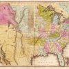 Louisiana Purchase through Early Statehood, 1803 through 1860
 Native Americans
 Choctaw Boundary Line
501-918-3025
calsfoundation@cals.org
calsfoundation@cals.org
Determining the Choctaw Boundary Line and thus the western boundary of Arkansas below the Arkansas River was a process that involved political maneuvering, treaties with the Choctaw tribe, and other negotiations. The line was not even determined for one small strip of land until 1905.
The Louisiana Purchase opened up a vast territory for the United States, and a few pioneers began to move into the lands west of the Mississippi River. In 1818, the first treaty was negotiated with the Quapaw tribe for the land west of a line that ran south from the “little rock” on the Arkansas River. The formation of Arkansas Territory in March 1819 brought more settlers. The settlers considered the lands to be in the public domain, but the U.S. government had its own ideas about other uses for some of the land.
With the Quapaw’s title to the land extinguished, President James Monroe named generals Andrew Jackson and Thomas H. Hinds to negotiate with the Choctaw an exchange of tribal lands in Mississippi for some of the land obtained from the Quapaw. The Choctaw were not impressed with the treaty, but Jackson threatened that “the Great Father in Washington” would be displeased if they did not agree. The generals also distributed $4,500 in cash to tribal leaders. The Treaty of Doaks Stand was signed on October 18, 1820, and gave all the land west of a line running from a point opposite Point Remove Creek and south to near Fulton (Hempstead County) on the Red River to the Choctaw.
This placed the Choctaw Line 450 miles east of the legal frontier and deprived Arkansas Territory of seventeen townships of land already surveyed and advertised for sale. James Miller, territorial governor of Arkansas, sent a memorial to Congress with concerns about the line defined by the 1820 treaty, but the treaty was approved before Miller’s special messenger reached Washington DC. In 1821, Henry Downs arrived in Arkansas and surveyed the line per the 1820 treaty. Downs recommended that the line be moved farther west, given that 3,000 white settlers would be displaced. Delegates for Congress made the boundary line an election question. In 1821, Edmond Folsom, a mixed-blood Choctaw from Mississippi, was named removal agent for the Choctaw. Between 1822 and 1824, Congress passed several acts concerning the line, with the last putting the line forty miles west of the southwest corner of Missouri, but the Choctaw had to agree. Congress was so sure that the Choctaw would agree to this new line that they had it surveyed.
In November 1824, a Choctaw delegation arrived in Washington to negotiate the line. For approximately ninety days, the government entertained the delegation lavishly, spending $2,500 for liquor, $400 for jewelry, and $1,100 for clothing. On January 20, 1825, a new agreement set the Choctaw Line at a point 100 paces east of old Fort Smith (Sebastian County) and running due south. James S. Conway was selected to survey this new line. Arkansas residents complained bitterly to Conway, saying that the new line deprived Arkansas of valuable mineral resources. For whatever reasons, Conway did not run the survey due south and angled in a southwesterly direction, depriving the Choctaw of land.
The white residents of the disputed area mostly stayed where they had settled. Many had expended all their resources to move and had no means to move again. A few families relocated into Texas. Folsom’s attempts to convince the Choctaw to remove were not very successful, and, by 1828, there were only eight Choctaw being served at the Choctaw agency on the Arkansas River and between forty and fifty located on Red River. Because the Choctaw in Mississippi were concerned that the white settlers would commit outrages against them or their property if they moved, they did not relocate to their new land.
The white settlers were not satisfied with Conway’s line, and yet another attempt was made in 1836 to establish the line forty miles west of Missouri when the constitution for Arkansas Territory to become the state of Arkansas was submitted. The Choctaw protested the proposed constitution and requested an amendment. The Arkansas constitution passed as amended to set the Choctaw Line as established in the 1825 treaty.
The Choctaw, always suspicious of the 1825 Conway line, saw a reason for a new survey by claiming that the old survey marks were faded. A new treaty was signed in 1855 and again set the Choctaw Line 100 paces east of old Fort Smith and running due south. Finally on January 3, 1858, a new crew began to survey the Choctaw Line and proceeded only eight miles from Fort Smith before it became clear that the old survey was in error. When the surveyors asked for directions from Washington, they were told only to resurvey the 1825 Conway line. Protests over this survey were ignored and faded over the years leading up to the Civil War.
During the Civil War, most Arkansans—and the Choctaw—sided with the Confederacy and, after the war, had to renegotiate their status. The Choctaw signed another treaty on April 28, 1866. They maintained that the Choctaw Line with Arkansas had never been property surveyed, and the government agreed with them this time. Even with the agreement, no action was taken until March 1875, when a measure was adopted by Congress to determine the correct line. Two years later, Henry McKee was appointed to check the survey and determine the correct line. McKee determined that the Choctaw were entitled to an appropriation of $175,049.57 at $1.25 per acre for land lost due to the erroneous survey. In 1888, the Choctaw were finally paid $68,102.00, or $.50 per acre.
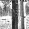
The Choctaw Line was at last settled at the erroneous Conway survey line of 1825, but a small section of land on the east side of the Poteau River remained a trouble spot. This section, two miles wide and twelve miles long, was separated from the rest of the Choctaw’s land by the Poteau River and became a no-man’s-land, a home to outlaws and lawlessness. To deal with the lawlessness, the federal district court of western Arkansas was given jurisdiction over this strip of land.
Businesses began to build in the strip, and Arkansas started collecting taxes even though the land belonged to the Choctaw. When the Dawes Act was passed in 1887, the strip was excluded from land to be allotted. Arkansas finally petitioned Congress for consent to make the strip an official part of Arkansas. On February 11, 1905, Congress passed an act making the strip of land part of Arkansas. On February 16, 1905, the Arkansas legislature accepted the strip as an official part of Arkansas, and the western boundary was settled.
For additional information:
Baird, W. David. “Arkansas’s Choctaw Boundary: A Study of Justice Delayed.” Arkansas Historical Quarterly 28 (Autumn 1969): 203–222.
Carter, Clarence Edwin, ed. The Territorial Papers of the United States. Vols. 19 and 20. Washington DC: U.S. Government Printing Office, 1934.
DeRosier, Arthur H., Jr. The Removal of the Choctaw Indians. Knoxville: University of Tennessee Press, 1999.
Carolyn Kent
Jacksonville, Arkansas


Comments
No comments on this entry yet.