 Cleburne County Map
 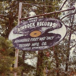 Rimrock Records Sign
  Rock Formations
501-918-3025
calsfoundation@cals.org
calsfoundation@cals.org
| Latitude and Longitude: | 35°39’49″N 091°50’52″W |
| Elevation: | 1,043 feet |
| Area: | 3.08 square miles (2020 Census) |
| Population: | 190 (2020 Census) |
| Incorporation Date: | June 27, 1968 |
Historical Population as per the U.S. Census:
|
1810 |
1820 |
1830 |
1840 |
1850 |
1860 |
1870 |
1880 |
1890 |
1900 |
|
– |
– |
– |
– |
– |
– |
– |
– |
– |
– |
|
1910 |
1920 |
1930 |
1940 |
1950 |
1960 |
1970 |
1980 |
1990 |
2000 |
|
– |
– |
– |
– |
– |
– |
163 |
234 |
262 |
255 |
|
2010 |
2020 |
|
|
|
|
|
|
|
|
|
244 |
190 |
|
|
|
|
|
|
|
|
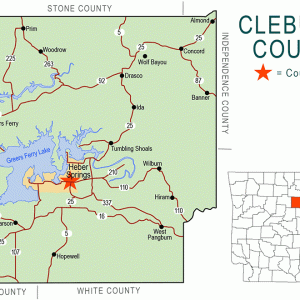
Concord is a town located in the northeastern corner of Cleburne County. It is perhaps most well known as the home of Rimrock Records.
Until 1808, the main inhabitants of Cleburne County were Native Americans who lived in the lowlands around the Little Red River. The Osage controlled most of northern Arkansas and used the area, including Cleburne County, as hunting grounds. In 1808, the United States purchased the land from the Osage, and the first Euro-American settlers arrived. In 1817, the United States established a treaty with the Cherokee, giving them the land between the White and Arkansas rivers west of a line stretching from near Morrilton (Conway County) to just west of Batesville (Independence County). This Old Cherokee Boundary Line retains a significant presence in the lexicon of Cleburne County, where it is often used to describe land and locations. This is especially true of the area near Concord and Drasco (Cleburne County).
Thomas Owen Brock and his family arrived in the area that would become Concord from Towns County, Georgia, shortly after the Civil War. A Mr. Colton held the patent on much of the land in the area. However, with no one living on the land, it was open for homesteading. Brock went to Batesville to register a homestead of 160 acres. This homestead became known as Paling Springs. Paling Springs, and later Concord, was located along a wagon route known as the Military Road. Later, this road became known as the Batesville-Clinton Road, then Highway 25 North. Other early settlers included the Bell, Clark, Hall, Martin, and Miller families, most from the same region of Georgia.
Prior to 1883, Paling Springs, and the Healing Springs Township of which it was a part, were included in Independence County. This land was annexed when Cleburne County was established. Later that year, as a part of managing the newly formed county, the townships were reconfigured, and Paling Springs was assigned to the newly created Grassy Township. In 1887, a post office was established in the area. The post office was named Tina, after an area resident.
In 1877, Washington Lafayette Brock and his wife, Charlotte, gave a deed for the first state-funded school in the area. Around that same time, a vote was held to name the church and cemetery; the congregation settled upon the name Concord. Originally, this name was only formally used for the church, cemetery, and school. The church—at the time a simple log structure—served as the gathering place for the community, hosting community singings and meetings in addition to church services.
In 1905, the Concord post office began operating out of a store in the community. This store’s second story also featured a meeting area for the Masons. Sometime in the early twentieth century, postal service to the Concord post office was discontinued. At that time, mail for Concord residents was sent to the post office in Wolf Bayou (Cleburne County). In 1946, postal service resumed to Concord in a post office that—for the first time—was officially named Concord.
During Prohibition and the Great Depression, the hills and deep woods surrounding Concord made for great cover for whiskey stills. It was said that Concord and Drasco were home to the county’s most notorious bootleggers and moonshiners. The area’s proclivity for illegal alcohol has allegedly persisted into the modern era. It was reported that, during the surveying of the area for the construction of Greers Ferry Dam and Lake, that U.S. Army Corps of Engineers workers uncovered many whiskey stills in operation in the hills of northern Cleburne County.
In the late 1920s, Wolf Bayou, Banner (Cleburne County), and Almond (Cleburne County) schools consolidated with Concord so that a high school could be supported. Prior to this, students attending school past the eighth grade had to go to high school in Heber Springs (Cleburne County). The Concord school then consolidated with the school at Drasco. The residents of Drasco were vocally against the school’s placement in Concord, believing that Drasco was the most suitable location. However, in 1930, a high school was constructed at Concord due to its central location for all communities served by the school. This building burned down in February 1968.
Prior to the 1930s, most families in Concord were subsistence farmers. In the late 1930s and early 1940s, poultry farming and processing became a major way of life in the area. Chicks were hatched elsewhere and then brought to Concord to be raised and processed. In the 1950s, the processing facilities moved to Batesville, as the city had ready access to transportation. The raising of chickens, especially broilers, remains key to the economic survival of Concord.
Until the late decades of the twentieth century, Concord was home to several stores, a post office, a café, a box factory, and a pallet mill. Concord was also home to Rimrock Records, where many songs by well-known area artists, such as Wayne Raney, were recorded.
For additional information:
Barger, Carl J. Cleburne County and Its People. Vol. 2. Bloomington, IN: AuthorHouse, 2008.
Berry, Evalena. Time and the River: A History of Cleburne County. Little Rock: Rose Publishing Company, 1982.
Sartain, Kimberly. “The History of Concord—The Beginnings of a Community—Part 1.” Cleburne County Historical Society Journal 46 (Fall 2020): 53–55.
Emilee Baker
Pangburn, Arkansas


Comments
No comments on this entry yet.