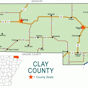
 Clay County Map
501-918-3025
calsfoundation@cals.org
calsfoundation@cals.org
| Latitude and Longitude: | 36°23’30″N 090°43’51″W |
| Elevation: | 289 feet |
| Area: | 0.62 square miles (2020 Census) |
| Population: | 65 (2020 Census) |
| Incorporation Date: | June 22, 1905 |
Historical Population as per the U.S. Census:
|
1810 |
1820 |
1830 |
1840 |
1850 |
1860 |
1870 |
1880 |
1890 |
1900 |
|
– |
– |
– |
– |
– |
– |
– |
– |
– |
– |
|
1910 |
1920 |
1930 |
1940 |
1950 |
1960 |
1970 |
1980 |
1990 |
2000 |
|
244 |
242 |
275 |
198 |
176 |
167 |
142 |
112 |
120 |
97 |
|
2010 |
2020 |
|
|
|
|
|
|
|
|
|
100 |
65 |
|
|
|
|
|
|
|
|
Datto is a town in Clay County situated just north of U.S. Highway 67. Created when the railroad was built through the area at the beginning of the twentieth century, Datto is five miles from Success (Clay County).
Although most of Clay County is farmland today, it was once heavily forested. Four rivers flow through the county, providing early transportation corridors. Osage, Shawnee, Delaware, and Quapaw tribes—as well as French explorers—are all known to have visited the area. A military road known as the Southwest Trail was constructed through the area during Arkansas’s territorial period, linking Missouri to the southwestern corner of the territory, which was then Fulton (Hempstead County). Isaac Day came to the area late in the nineteenth century to operate a steamboat on the Current River. Day also owned a sawmill to process trees that were being harvested in the area between 1890 and 1900.
Around 1900, the Cotton Belt Railroad constructed a line that passed through Clay County on the same approximate route as the Southwest Trail. The town of Thurman—about a mile southeast of Datto—was displaced because its citizens wanted the community to be located along the railroad. The land of Isaac Day and of his sons, Charles and Delmar Day, became the site of the new community. The family wanted to name the railroad depot and post office Dayton, but the postal authorities declined the name, and Datto was accepted as a compromise. The post office opened for business in 1900 with Charles Day as the first postmaster; the town was incorporated in 1905. A Landmark Missionary Baptist church was organized in 1902 with nineteen charter members.
A school was already meeting in Datto by 1900 under the direction of Edward C. Skagg. A stave mill and a hardware mill were built, and the town of Datto was a thriving timber town for some years. As more land was cleared, cotton was planted; over the years, farmers also added corn, soybeans, and rice. A bank operated in Datto during the 1920s but closed during the Depression. With the growth of automobile traffic in the early twentieth century, a road was placed along the railroad tracks. Paved in 1928, the highway became U.S. Highway 67. By 1933, the town of Datto had three grocery stores, a drugstore, two barbershops, a cotton gin, and Methodist and Baptist churches. The Baptist congregation dedicated a new building in 1947.
In 1958, a wider highway was paved south of town, replacing U.S. Highway 67. The old pavement continues to be used in Datto; the stretch of old highway was placed on the National Register of Historic Places in 2004. Children in Datto attend school in Corning (Clay County).
Datto is the birthplace of songwriter Wilbur Steven “Bill” Rice.
For additional information:
Tedford, Leroy Carson. A History of the Current River Baptist Association. Poplar Bluff, MO: General Baptist Publishing House, 1947.
Webb, Robert T., Bruce Brown, and Patsy Truscott, compilers. History and Traditions of Clay County. Piggott, AR: Webb, Truscott, and Brown, 1933.
Steven Teske
Butler Center for Arkansas Studies


My grandpa owns the Datto town seat and all the land from Reno to Datto.