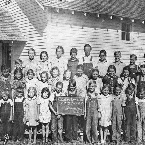
 Clantonville School
501-918-3025
calsfoundation@cals.org
calsfoundation@cals.org
| Latitude and Longitude: | 36°29’25″N 093°55’55″W |
| Elevation: | 1,535 feet |
| Area: | 6.56 square miles (2020 Census) |
| Population: | 436 (2020 Census) |
| Incorporation Date: | August 27, 1934 |
Historical Population as per the U.S. Census:
|
1810 |
1820 |
1830 |
1840 |
1850 |
1860 |
1870 |
1880 |
1890 |
1900 |
|
– |
– |
– |
– |
– |
– |
– |
– |
– |
– |
|
1910 |
1920 |
1930 |
1940 |
1950 |
1960 |
1970 |
1980 |
1990 |
2000 |
|
– |
– |
– |
57 |
97 |
63 |
83 |
75 |
65 |
116 |
|
2010 |
2020 |
|
|
|
|
|
|
|
|
|
405 |
436 |
|
|
|
|
|
|
|
|
Gateway is a town in northeastern Benton County. The town’s northern boundary is the state line with Missouri. Gateway is located on U.S. Highway 62, and its existence is largely a result of the highway. Although some claim that the name of the town reflects its relationship to people entering Arkansas from Missouri, the town actually was named for an arch over the highway that read, “Gateway to Eureka Springs.”
Prior to the arrival of European explorers and American settlers, the Ozark Mountains were inhabited, but only sparsely. By the time of the Louisiana Purchase in 1803, the primary human residents were occasional visitors, especially the Osage of Missouri who came south into the Ozarks to hunt and fish. American settlers began arriving in the area in the 1820s, although three more decades would pass before legal claim was established by the settlers.
A country church was established in the area in 1840. Brothers Jacob and Joshua Roller received multiple land deeds on the formation west of Gateway now known as Roller Ridge. In 1857, Daniel Ash also received a land grant, making him the first owner of the land that would become Gateway. A post office was established at Roller Ridge in 1858; it maintained an intermittent existence until it was closed for good in 1868.
During the Civil War, the Battle of Pea Ridge was fought a few miles west of Ash’s farm on the far side of Roller Ridge in March 1862. After that battle, the area was officially under Federal control, although guerrilla bands often seized whatever moveable property they could find. After the war, a few small communities developed, including Clantonville, where Marion Clanton and his family set up a country store, a blacksmith shop, a sorghum mill, and a sawmill. A school was established at Clantonville before 1884. To the south, the Hurd family managed in 1881 to arrange a railroad switch with the St. Louis–San Francisco Railway (the “Frisco”) where trains could be loaded with ties harvested from his property. A post office called Herd Switch operated from 1890 until 1910, while a sawmill, an apple dryer, a tomato cannery, and a whiskey distillery came and went as local businesses near the switch.
The region’s economy suffered when the trees were all harvested, the apple crops suffered several years of disease, and the Depression began. During the Depression, a highway was built linking El Paso, Texas, to Niagara Falls, New York. U.S. Highway 62 is the only east-west highway in the United States that touches both Canada and Mexico. In Benton County, the building of the federal highway improved existing roads known as the Ozark Trail. Claude Fuller designed the improved highway, which local residents jokingly designated “Fuller’s Folly” because of the dangerous curves and hills. Floyd Barber operated a garage along the highway, and a grocery store and café were soon added. An arch (no longer standing) was erected near the businesses bearing the words “Gateway to Eureka Springs.” The café owner, W. J. Mills, constructed tourist cabins across the highway from his café. Gateway Chapel was built in 1934, and the town of Gateway sought incorporation the same year. Its population was fifty-seven in the 1940 census. Gateway received a post office in 1939.
In the mid-1940s, the Clantonville school (Fairview School District No. 1) was consolidated into the Garfield School District. The school building was used as a church and community center until 1980. The Garfield School District later became part of the Rogers School District.
While Rogers (Benton County) and Bentonville (Benton County) exploded with population due to businesses including Walmart Inc. and J. B. Hunt Transport Services Inc., tourism was more a source of income in the Gateway area. Pea Ridge National Military Park was established in 1963. Beaver Dam and Lake were completed in 1966. Both projects increased tourist traffic on the highway through Gateway beyond that attracted to Eureka Springs (Carroll County). By 1991, Gateway had gift shops, a service station, a bait and gun shop, a fresh fruit market, realty companies, a flea market, an RV business, and a church, which for a while affiliated with the Assemblies of God before it became nondenominational in 1977. The Gateway Rural Water Association served families in and near Gateway, and the Northeast Benton County Volunteer Ambulance Service made Gateway its center of operations.
The population of Gateway did not exceed 100 until the 2000 census. Ten years later, it had grown to more than 400. Businesses along the highway remain its source of income, including automotive services, a candy store, and a smoke shop. The U.S. Army Corps of Engineers maintains a park facility near Gateway; visitors pay fees at the Indian Creek Gatehouse.
For additional information:
Benton County Heritage Committee. History of Benton County, Arkansas. Rogers, AR: Benton County Heritage Committee, 1991.
Jines, Billie. Benton County Schools That Were. Volume 1. Ozark, MO: Dogwood Publishing, 1989.
Steven Teske
Butler Center for Arkansas Studies


Comments
No comments on this entry yet.