 Marie Gin
  Mississippi County Map
501-918-3025
calsfoundation@cals.org
calsfoundation@cals.org
| Latitude and Longitude: | 35°36’37″N 090°04’51″W |
| Elevation: | 236 feet |
| Area: | 0.15 square miles (2020 Census) |
| Population: | 108 (2020 Census) |
| Incorporation Date: | June 14, 1968 |
Historical Population as per the U.S. Census:
|
1810 |
1820 |
1830 |
1840 |
1850 |
1860 |
1870 |
1880 |
1890 |
1900 |
|
– |
– |
– |
– |
– |
– |
– |
– |
– |
– |
|
1910 |
1920 |
1930 |
1940 |
1950 |
1960 |
1970 |
1980 |
1990 |
2000 |
|
– |
– |
– |
– |
– |
– |
72 |
287 |
129 |
108 |
|
2010 |
2020 |
|
|
|
|
|
|
|
|
|
84 |
108 |
|
|
|
|
|
|
|
|
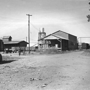
Named for the youngest daughter of Robert E. Lee Wilson, Marie is one of several towns founded by Lee Wilson & Company early in the twentieth century. It is located on State Highway 14 about two miles east of Interstate 55.
Periodically flooded by the Mississippi River, eastern Mississippi County was long a wooded swampland unattractive to early settlers of the state. Late in the nineteenth century, Lee Wilson began investing in this unwanted land, seeing its potential for production of wealth, first in timber and then in cotton. After funding a railroad, Wilson began harvesting the timber with his own lumber company. Clearing the land of trees, he exposed rich soil that had been frequently replenished by Mississippi River floods. Wilson also created several levee and drainage districts to protect the farmland, and he brought in hundreds of tenant farmers to grow cotton on his land. Wilson established several towns to meet the needs of his farmers, including Marie, Victoria (Mississippi County), Wilson (Mississippi County), and Armorel (Mississippi County). The homes and businesses in these towns were built by Wilson’s company, and the stores in Marie and the other towns were all part of Wilson’s financial empire.
The post office in Marie opened in 1903, and Marie became known mostly for its grocery store in the midst of rich farmland, all of which belonged to Wilson. Floods in 1912 and 1913 overwhelmed the levees and drainage system, but Wilson rebuilt what was damaged and continued his operations. He kept a close eye on every aspect of his business, and he communicated directly with store managers in Marie and other towns when the stores were not sufficiently profitable. Farmers on Wilson’s land included African-American, white, and Mexican immigrant workers.
Wilson’s levees, protected by armed guards from vandalism, preserved his property in southern Mississippi County during the Flood of 1927. The Drought of 1930 and the general economic ravages of the Depression were not so easily endured, however, and tenant farmers began to leave the land in hope of better opportunities elsewhere. The post office in Marie closed in 1935, and although the grocery store continued to operate, the earlier prosperity of the land was threatened. The Dyess Colony was established near Marie in 1934, leading to improvement of the highway that ran through Marie. During World War II, the company converted some of the cotton fields to alfalfa production and built a dehydration plant in Marie.
Construction of Interstate 55 through Mississippi County in the early 1960s generated hope for the future of Marie, and the town incorporated in 1963. Although the population was only 72 in the 1970 census, it had surged to 287 by 1980 before beginning to decline. In 2010, the census recorded eighty-four residents of Marie, sixty-six of whom were white and thirteen of whom were African American. The grocery store built by Lee Wilson & Company is still standing in the twenty-first century.
For additional information:
Edrington, Mabel F. History of Mississippi County, Arkansas. Ocala, FL: Ocala Star-Banner, 1962.
Whayne, Jeannie. Delta Empire : Lee Wilson and the Transformation of Agriculture in the New South. Baton Rouge: Louisiana State University Press, 2011.
Steven Teske
Butler Center for Arkansas Studies


Comments
No comments on this entry yet.