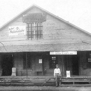
 Cedar Glades Store
 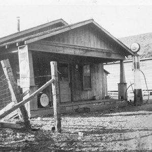 Cedar Glades
 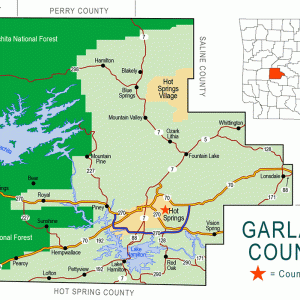 Garland County Map
501-918-3025
calsfoundation@cals.org
calsfoundation@cals.org
The community of Cedar Glades, located on the upper Ouachita River in Garland County, served as a transportation and commercial center amidst the sparsely settled Ouachita Mountains before the Civil War. The town typified rural upland Arkansas with its small farms and reliance on agriculture. Following the construction of Blakely Mountain Dam in the 1950s, the waters of Lake Ouachita covered Cedar Glades and the surrounding area. The lake’s completion necessitated a total, permanent evacuation of the town, and it ceased to exist.
Extensive archaeological remains exist in the upper Ouachita River valley; many fields bordering on the river contain evidence of Native American presence in the area. Caddo occupied the Ouachita Mountains in relatively small, widely dispersed settlements in the northern part of the region. By 1700, no European or Indian resident communities remained, although the area hosted numerous transient populations until the time of permanent American settlement.
After Arkansas became a part of the United States, few of the territory’s early citizens chose to settle in the rugged Ouachita Mountains. The region’s poor soils supported the small subsistence farms that dominated the upper Ouachita River valley up until the time of the Civil War. The Cedar Glades community became a significant trading and transportation center in the sparsely settled Ouachita Mountains prior to the Civil War. While residents remained widely dispersed across the countryside, the establishment of the Harold Post Office in 1845 (renamed Cedar Glades in 1883) indicates a concentration of citizens in the area.
The Civil War brought great disruption to the Cedar Glades area: both armies foraged and skirmished in the area, and bands of irregulars terrorized the population. After the war, the community grew, and by 1891, Goodspeed’s Biographical and Historical Memoirs of Western Arkansas estimated Cedar Glades residents as totaling 250. By 1900, various mills, blacksmith shops, woodworking shops, general stores, and other businesses served the citizenry, while the area’s small farms typified rural upland Arkansas. Baptist and Methodist churches were established, and a Church of Jesus Christ of Latter-day Saints served the area for a brief time as well. The Cedar Glades School was among the area’s largest. Local branches of fraternal organizations sprang up in and around Cedar Glades, such as the Henderson Masonic Lodge, which held its first meeting in Cedar Glades in 1860.
The roads that passed through the Cedar Glades community made the site a logical place for growth and development. The Little Rock and Fort Smith Road followed the base line in Saline County, bypassed the Saline River bottoms, then passed south of Marble (Garland County) and through Whittington (Garland County). The road crossed what is now Highway 7 at Ballew Springs—now known as Blue Springs (Garland County)—followed Little Blakely Creek to its junction with Big Blakely, and then continued west through Cedar Glades and Mount Ida (Montgomery County) on the way to Fort Smith (Sebastian County). Originally an Indian trail, it was traveled by early settlers. Later, a stage line utilized the route to transport passengers and goods to Fort Smith. Other roads converged near Cedar Glades as well: one went to Blue Mountain (Garland County) another went northwest to Avant (Garland County), another crossed the Ouachita River on its way to Bear (Garland County), and yet another went to Hot Springs (Garland County). These roads constituted the primary transportation routes into the surrounding area.
In the twentieth century, small farms supported the majority of the population. Modernization never occurred for Cedar Glades: paved roads; bridges; and water, sewer, and electrical service never made it to the area, although some residents enjoyed sporadic use of a local battery-powered electric system. Others communicated via a telephone exchange which connected Buckville (Garland County) and Cedar Glades, with a line eventually extending to Hot Springs.
After 1920, outside forces brought major disruption to the region, beginning a dislocation of the area’s population. Following the completion of the Remmel and Carpenter dams by Arkansas Power and Light (AP&L) near Hot Springs in the late 1920s, construction of another similar—but larger—facility at Blakely Mountain loomed on the horizon. As the project moved forward, AP&L and the Dierks company began land and timber acquisition programs in the proposed reservoir area. After World War II, when the federal government’s U.S. Army Corps of Engineers assumed control of the dam construction project, even more land was acquired. An exodus from the area began in the 1920s and culminated in the early 1950s with the completion of Blakely Mountain Dam and subsequent filling of Lake Ouachita.
Since the dam’s construction seemed imminent, residents made few changes to Cedar Glades’ physical landscape from the 1920s until the time that homes and businesses began to be dismantled or demolished in the 1940s. Schools closed, and organizations disbanded or moved—the Henderson Masonic Lodge’s last meeting at Cedar Glades was held in January 1951; later, the group met at a location near Mountain Pine (Garland County). Timber was cut, and land was cleared, but some brush was left for fish cover and spawning grounds in the new lake. Graves were moved in 1951, when contractors transported remains from their original burial grounds in the reservoir area to existing cemeteries as well as several sites established for the specific purpose of accommodating the graves. The White Plains Baptist Church disbanded in 1930, believing a “dam would soon flood this country.” However, the Cedar Glades Baptist Church remains active today: the congregation left its building and began holding services near Mountain Pine as the dam reached completion. Postal service ended in the reservoir area on August 31, 1953, with the closure of the Cedar Glades Post Office.
Blakely Mountain Dam was dedicated on July 4, 1956. The reservoir created by the dam, Lake Ouachita, extends thirty-four miles upstream and covers more than 48,000 acres of land, including the former location of Cedar Glades.
Today, the Buckville Baptist Church (which was moved to a nearby location that was not inundated) and Cemetery (which remains in its original location) are the only tangible reminders of the former area towns; both now stand on the northern shore of Lake Ouachita. Each June, the church and cemetery site hosts a reunion of hundreds of people who once lived in communities within the now-inundated area.
For additional information:
Biographical and Historical Memoirs of Western Arkansas. Chicago: Goodspeed Publishing Company, 1891.
“Cedar Glades.” Subject file. Garland County Historical Society Archives, Hot Springs, Arkansas.
Richter, Wendy. “‘Swallowed Up in One Gulp’: Lost Communities of the Upper Ouachita River Valley.” PhD diss., Arkansas State University, 2005.
Richter, Wendy Bradley, and Inez E. Cline. They Can’t Go Home: A History of Northwestern Garland County, Arkansas. N.p: 1990.
Richter, Wendy. “The Impact of Blakely Mountain Dam on Northwestern Garland County.” The Record 43 (2002): 1–11.
———. “Ordinary Communities, Extraordinary Experiences: A Garland County Exodus.” The Record 61 (2020): 2.1–2.24.
Wendy Richter
Ouachita Baptist University


Comments
No comments on this entry yet.