 Geography and Geology
501-918-3025
calsfoundation@cals.org
calsfoundation@cals.org
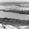
The Tyronza River rises in Mississippi County and flows primarily southwest until it empties into the St. Francis River just north of Parkin (Cross County). It no longer resembles the stream that it was up until the early twentieth century, as it has been channelized, ditched, and had its meander loops cut-off.
Before the formation of the levee and drainage districts in the late nineteenth century that rerouted and channelized existing streams, the Tyronza River arose out of a body of water called Carson Lake located southwest of Osceola (Mississippi County). From there, it flowed across low swampy land, a region the locals referred to as the “scatters of Tyronza,” into Tyronza Lake before narrowing down into the regular path it followed until reaching the St. Francis River. Tyronza Lake was simply a widening of the river channel, probably as a result of the land falling during the series of earthquakes that occurred along the New Madrid fault line in 1811 and 1812. Both Carson Lake and Tyronza Lake have since been drained and are used for agricultural land.
Near Tyronza (Poinsett County), a considerable amount of water was diverted out of the main channel along a large meander into what is now referred to as Dead Timber Lake, which acted as a distributary of the Tyronza River. Around the beginning of the twentieth century, dredging in the Tyronza’s main channel resulted in a reversal of the flow, and water began flowing out of Dead Timber Lake into the Tyronza River, resulting in the death of the distributary. The meander where the Dead Timber Lake node was located was eventually cut off by a ditch and no longer is a part of the river. A second, larger cut-off lies in Crittenden County north of Earle.
In the twenty-first century, the Tyronza River begins approximately six miles southwest of Blytheville (Mississippi County) as Ditch No. 31. It flows as a shallow agricultural ditch to a point three miles north of Dyess (Mississippi County), a distance of approximately thirty-four miles, where it finally officially becomes the Tyronza River. It flows on for another forty-three miles across Mississippi County and through Poinsett and Crittenden counties until it empties into the St. Francis River just north of Parkin in Cross County. It is the third-largest tributary to the St. Francis River, after the Little River and the L’Anguille River, with a length of just over eighty-four miles.
There are a large number of Mississippian Period villages lying along the length of the Tyronza River from Parkin to the area near Tyronza, which are believed to be those of the chiefdom of Casqui visited by Spanish conquistador Hernando de Soto in 1541. The Tyronza River is believed to be the river that de Soto’s chroniclers referred to as the River of Casqui.
The river is currently targeted for research, as it is home to a federally protected variety of freshwater mussel, the pearly fat pocketbook mussel.
For additional information:
Clayton, Lawrence A., Vernon James Knight Jr., and Edward C. Moore, eds. The De Soto Chronicles: The Expedition of Hernando de Soto to North America in 1539–1543. 2 vols. Tuscaloosa: University of Alabama Press, 1993.
Hudson, Charles. Knights of Spain, Warriors of the Sun: Hernando de Soto and the South’s Ancient Chiefdoms. Athens: University of Georgia Press, 1997.
Morgan, Arthur Ernest, and Ora Grover Baxter. Report on the St. Francis Valley Drainage Project. Vol. 1. Washington DC: Government Printing Office, 1911.
Morse, Phyllis A. Parkin: The 1978–1979 Archeological Investigations of a Cross County, Arkansas Site. Research Series No. 13. Fayetteville: Arkansas Archeological Survey, 1981.
———. “The Parkin Archeological Site and Its Role in Determining the Route of the de Soto Expedition.” In The Expedition of Hernando de Soto West of the Mississippi, 1541–1543, edited by Gloria A. Young and Michael P. Hoffman. Fayetteville: University of Arkansas Press, 1993.
Wentz, N. J., N. D. Henderson, and A. D. Christian. “Assessment and Characterization of Physical Habitat, Water Quality, and Biotic Assemblages of the Tyronza River, Arkansas.” Journal of the Arkansas Academy of Science 65 (2011): 143–152. Online at http://libinfo.uark.edu/aas/issues/2011v65/v65a19.pdf (accessed November 9, 2021).


Comments
No comments on this entry yet.