 Civil War Archaeology
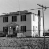 Hempstead County
 Historic Preservation
 Military
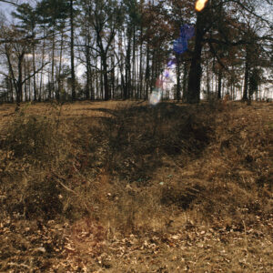 Dooley's Ferry Fortifications
 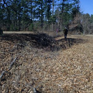 Dooley's Ferry Fortifications
501-918-3025
calsfoundation@cals.org
calsfoundation@cals.org
The Dooley’s Ferry Fortifications Historic District features a series of redoubts and trenches that Confederate soldiers constructed in 1864 and 1865 to protect the approaches to Texas via the Red River during the waning days of the Civil War.
In mid-September 1864, Major General Sterling Price led a force of 12,000 men—including most of the Confederate cavalry serving in the state—on a raid into Missouri, leaving the remaining Confederate troops in Arkansas under the command of Major General John Bankhead “Prince John” Magruder. Magruder faced the challenge of defending southwestern Arkansas as aggressive Federal patrols probed the region in the absence of Maj. Gen. Price and the Rebel cavalry. His ability to defend the region was further complicated by a lack of labor—particularly slave labor—to construct fortifications as Arkansans took their human property to Texas, where there was less chance of their escaping to Union lines or being freed by Federal patrols. Maj. Gen. Magruder wrote in a November 5, 1864, letter, “I am told that over 150,000 negroes have gone from Missouri and Arkansas into Texas, and leaving out all considerations of fairness, I fear that if the few that remain here are impressed, those who would otherwise sow and plant would emigrate to Texas, and through the depopulation of the country we should not be able to support an army through another season.” He added, “I am the only officer I know of in the Trans-Mississippi Department who causes his troops to labor on fortifications.”
Magruder recognized the need for fortifications on the Little Missouri and Ouachita rivers “and certainly Fulton and Dooley’s Ferry,” knowing that holding the line of the Ouachita was essential to the defense of the Red River, and he would work to establish supply depots for Confederate troops in that area. He also applied to have slaves sent from the District of Texas to construct fortifications on the Ouachita and Little Missouri rivers, contending that Confederate law allowed him to impress only eighty-five local slaves as laborers and that calling others into forced labor would lead their owners to flee to Texas.
He ordered Major General John Horace Forney to move his division to the Spring Hill (Hempstead County) area, adding that “it would be well to place the artillery as near Dooley’s Ferry, on Red River, as possible.” Dooley’s Ferry, located south of Spring Hill, had long been an important crossing point on the Red River, being situated where two important early roads through Arkansas—the Southwest Trail and Trammel’s Trace—intersected.
The ground above Dooley’s Ferry also provided excellent locations for defensive fortifications, with high ground flanked by lakes and swampy areas commanding the road network leading to the ferry. By mid-December, Magruder announced that the works at Fulton and Dooley’s Ferry were “about to be constructed by troops.” That construction apparently began in January when troops under Brigadier General Alexander T. Hawthorne were ordered to Dooley’s Ferry, “bringing all of their axes, spades, &c, for working upon fortifications.”
The impressive works at Dooley’s Ferry would never face combat conditions. Many Union troops would be transferred east of the Mississippi River to take part in operations against Confederate troops in Alabama and elsewhere. Rebel troops in Arkansas, stationed in a region that was stripped bare by four years of occupation by men of both armies, lacked both the will and the supplies to mount a substantial offensive operation. After the collapse of Confederate armies in the East, the major Confederate armies in the Trans-Mississippi would themselves lay down their arms in June 1865.
While they never witnessed a shot fired in wartime, the fortifications at Dooley’s Ferry remain today as witnesses to Confederate strategy in Arkansas during the waning days of the Civil War. They are the largest and best-preserved surviving set of fortifications in southern Arkansas. Archaeological work conducted by the Arkansas Archeological Survey in 2011 and 2012 promises to reveal additional information about the site. The Dooley’s Ferry Fortifications Historic District was listed on the National Register of Historic Places on September 22, 2004.
For additional information:
Christ, Mark K. “Dooley’s Ferry Fortifications Historic District.” National Register of Historic Places nomination form, 2004. On file at Arkansas Historic Preservation Program, Little Rock, Arkansas.
Christ, Mark K., ed. Rugged and Sublime: The Civil War in Arkansas. Fayetteville: University of Arkansas Press, 1994.
Drexler, Carl Gilbert. “Dooley’s Ferry: The Archaeology of a Civilian Community in Wartime.” PhD diss., College of William and Mary, 2013. Online at https://scholarworks.wm.edu/etd/1539623627/ (accessed July 7, 2022).
Turner, Mary Nell. “Dooley’s Ferry on the Red River: A Brief History.” Journal of the Hempstead County Historical Society 13 (1994): 12–22.
The War of the Rebellion: A Compilation of the Official Records of the Union and Confederate Armies. Vol. 41, Part 4, pp. 1030, 1033, 1114, 1333. Washington DC: Government Printing Office, 1893.
Williams, Keenan. “Dooley’s Ferry in the Civil War.” Journal of the Hempstead County Historical Society 13 (1994): 37–49.
Mark K. Christ
Arkansas Historic Preservation Program


Comments
No comments on this entry yet.