 European Exploration and Settlement, 1541 through 1802
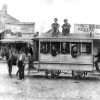 Transportation
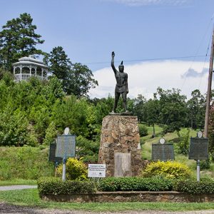 Caddo Gap Monument
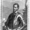
 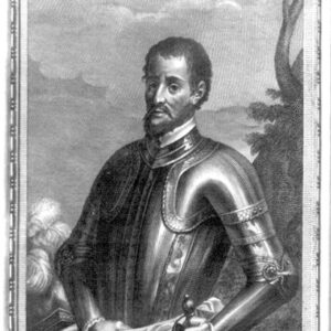 Hernando de Soto
 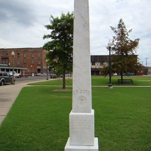 De Soto Monument
 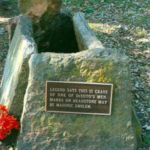 Purported de Soto Soldier Grave
501-918-3025
calsfoundation@cals.org
calsfoundation@cals.org
When the Spanish expedition of Hernando de Soto crossed the Mississippi River on June 28, 1541 (June 18 on the Julian calendar, which was used at the time), it entered what is now Arkansas. It spent the next eleven months roaming around the state until de Soto’s death on May 31, 1542 (May 21 on the Julian calendar). After his death, the survivors made their way to Mexico.
There have been many attempts to identify the expedition’s route through Arkansas, using information from the four written accounts of the expedition. Three of these were written by men who had accompanied the expedition, and the fourth was authored forty or fifty years later, based on interviews with survivors. The route reconstructions have yielded widely differing results. A major problem is determining where the expedition crossed the Mississippi River. Although place names, directions of travel, and topographic features are mentioned in the written narratives, even a small error in one place can throw everything off after that, so most attempts at reconstruction end in failure.
In the 1930s, the U.S. Congress authorized formation of the United States De Soto Expedition Commission, tasked with gathering all available evidence to identify the route of the expedition. The commission was headed by Smithsonian Institution anthropologist John R. Swanton, who also wrote the final report of the commission, issued in 1939. One member was John R. Fordyce of Hot Springs (Garland County), vice chair of the commission and one of its most active participants. Unfortunately, they relied heavily on modern place names and terrain matching up with places mentioned in the narratives, and this undoubtedly introduced significant errors.
Fordyce’s research was the basis of most of the 1939 reconstruction of the route through Arkansas. Although he was an avid historian, he had no access to archaeological information, an important source for helping to fine tune the geographical interpretations. He had been investigating the route on his own for years, but he also had a business interest in showing that the expedition discovered the location of Hot Springs. Fordyce believed that the association with the Spanish expedition could be used as a draw to increase tourism. He and Swanton identified the place where the expedition crossed the Mississippi River as just north of the mouth of the Arkansas River, based on their route reconstruction in Mississippi. They produced a map of their reconstruction and included it in the 1939 report. The Arkansas section depicted the expedition exploring along the Mississippi River north of the crossing, then following the Arkansas River west before heading into the Ouachita Mountains and ultimately following the Ouachita River south into Louisiana. The Swanton route, as it came to be known, was accepted for many decades as the best reconstruction of the expedition’s path.
The first attempt to use archaeological evidence to refine the route was in 1951, when three archaeologists—Philip Phillips, James A. Ford, and James B. Griffin—published a work on the archaeology of the Lower Mississippi River Valley. Included was their reinterpretation of the route that encompassed archaeological information known at that time. In terms of the Arkansas route, the most important change was that these archaeologists placed the Mississippi River crossing farther north.
Beginning in the 1970s, archaeologists in the Southeast began studying the expedition in light of more modern archaeological knowledge. The number of scholars involved in this research increased, especially in the 1980s and 1990s, with historians and experts from other fields joining in. Much of this work produced little of lasting significance, but many important refinements of the route came out of collaborations. The work of University of Georgia anthropologist Charles Hudson and his students was especially fruitful, and his systematic concentration on each segment of the route in collaboration with local experts produced what is generally considered to be the best approximation of the expedition route.
It is clear from the narratives that after crossing the river, the expedition moved north through terrible swamps. It entered the territory of a powerful chief named Casqui, staying at his capital town for a few days before moving north to visit a rival chief named Pacaha. The discovery of Spanish artifacts, coupled with geographical details from the accounts, has convinced most scholars that the capital village of Casqui is the Parkin Site, located in today’s Parkin Archeological State Park. After some time in northeastern Arkansas, the expedition traveled south (probably along the St. Francis River), visiting some major Native American villages before heading west into the state’s interior. The discovery of a handful of Spanish artifacts supports the southward movement, but archaeological evidence of the route to the west is nonexistent, with the lone exception of a single brass Clarksdale bell from the Carden Bottom area.
The narratives clearly indicate that the expedition traveled west, meandering over many parts of the state. Most scholars agree that the initial trek west proceeded north of the Arkansas River, probably making at least one foray north into the foothills near Batesville (Independence County). At some point, the expedition crossed the Arkansas River and undoubtedly made contact with some Caddoan peoples. It spent October fighting with a fierce tribe called the Tula somewhere near present-day Fort Smith (Sebastian County). Archaeologists have not identified the exact location of these people, but they were clearly not Caddo.
The fights with the Tula convinced Hernando de Soto to turn around and travel to the east. Based on information from other Indians, the expedition decided to winter in a place called Utiangüe, which had large amounts of stored corn. This was south of the Arkansas River, probably somewhere near present-day Little Rock (Pulaski County). When the winter ended, it made its way back to the Mississippi River. At a village called Guachoya, presumed to be somewhere near present-day Lake Village (Chicot County), de Soto died.
After de Soto’s death, his lieutenant Moscoso assumed command, and the surviving expedition members decided to abandon their mission and make their way back to New Spain (present-day Mexico). They first tried to travel overland, but the lack of food and water in the desert of Texas convinced them to return to Guachoya, where they spent months constructing barges and rafts, which they used to sail down the Mississippi River (under attack from hostile natives the entire way), then along the Gulf Coast to Mexico.
Unfortunately, the lack of archaeological evidence from the western and southern part of the state means that scholars are unsure of the route in these areas. Charles Hudson’s approximation is considered the most accurate based on current knowledge.
For additional information:
Childs, H. Terry, and Charles H. McNutt. “Hernando de Soto’s Route from Chicaca through Northeast Arkansas: A Suggestion.” Southeastern Archeology 28 (Winter 2009): 165–183.
Clayton, Lawrence A., Vernon James Knight Jr., and Edward C. Moore, eds. The De Soto Chronicles: The Expedition of Hernando de Soto to North America in 1539–1543. 2 vols. Tuscaloosa: University of Alabama Press, 1993.
Galloway, Patricia Kay. The Hernando de Soto Expedition: History, Historiography, and the “Discovery” of the Southeast. Lincoln: University of Nebraska Press, 1997.
Hudson, Charles. Knights of Spain, Warriors of the Sun: Hernando de Soto and the South’s Ancient Chiefdoms. Athens: University of Georgia Press, 1997.
Schaeffer, Kelly. “Disease and de Soto: A Bioarchaeological Approach to the Introduction of Malaria to the Southeast US.” MA thesis, University of Arkansas, Fayetteville, 2019. Online at https://scholarworks.uark.edu/etd/3173/ (accessed July 6, 2022).
Sloan, David. “The Expedition of Hernando de Soto: A Post-Mortem Report.” Arkansas Historical Quarterly 51 (Spring 1992): 1–29.
———. “The Expedition of Hernando de Soto: A Post-Mortem Report, Part II.” Arkansas Historical Quarterly 51 (Winter 1992): 297–327.
Swanton, John R. Final Report of the United States De Soto Expedition Commission. Washington DC: Smithsonian Institution Press, 1985.
Young, Gloria A., and Michael P. Hoffman, eds. The Expedition of Hernando de Soto West of the Mississippi, 1541–1543. Fayetteville: University of Arkansas Press, 1993.
Jeffrey M. Mitchem
Arkansas Archeological Survey


A long time back, a man called me seeking information on a gold coin he had found above Valley Head, Alabama, using a metal detector. He was trying to reach my cousin of the same name because someone had told him my cousin was familiar with coins. I asked the man to describe what he found. I remember the coin was either hexagon or octagon shaped with stalks of corn stacked up and Roman numerals 1505 on it. I looked up the coin after our conversation and found Spanish coins with same characteristics. I never talked with the man again but thought it proof that de Soto did pass through this region or close by. Valley Head was an important location for the Cherokee at that time of course.