


501-918-3025
calsfoundation@cals.org
calsfoundation@cals.org
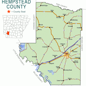
| Region: | Southwest |
|---|---|
| County Seat: | Hope |
| Established: | December 15, 1818 |
| Parent County: | Arkansas |
| Population: | 20,065 (2020 Census) |
| Area: | 727.20 square miles (2020 Census) |
| Historical Population as per the U.S. Census: | |||||||||
|
1810 |
1820 |
1830 |
1840 |
1850 |
1860 |
1870 |
1880 |
1890 |
1900 |
|---|---|---|---|---|---|---|---|---|---|
|
– |
2,246 |
2,512 |
4,921 |
7,672 |
13,989 |
13,768 |
19,015 |
22,796 |
24,101 |
|
1910 |
1920 |
1930 |
1940 |
1950 |
1960 |
1970 |
1980 |
1990 |
2000 |
|
28,285 |
31,602 |
30,847 |
32,770 |
25,080 |
19,661 |
19,308 |
23,635 |
21,621 |
23,587 |
|
2010 |
2020 |
|
|
|
|
|
|
|
|
|
22,609 |
20,065 |
|
|
|
|
|
|
|
|
| Population Characteristics as per the 2020 U.S. Census: | ||
| White |
11,006 |
54.9% |
|---|---|---|
| African American |
5,683 |
28.3% |
| American Indian |
140 |
0.7% |
| Asian |
96 |
0.5% |
| Native Hawaiian or Other Pacific Islander |
5 |
0.0% |
| Some Other Race |
1,783 |
8.9% |
| Two or More Races |
1,352 |
6.7% |
| Hispanic Origin (may be of any race) |
2,953 |
14.7% |
| Population Density |
27.6 people per square mile |
|
| Median Household Income (2019) |
$42,860 |
|
| Per Capita Income (2015–2019) |
$21,521 |
|
| Percent of Population below Poverty Line (2019) |
22.7% |
|
Hempstead County, located in the southwest corner of the state, was organized in 1818, before Congress established Arkansas Territory. The Missouri territorial legislature had created three counties from Arkansas County—Hempstead, Clark, and Pulaski. The county was named for Edward Hempstead, the first delegate to Congress from Missouri Territory. It has been the home of five Arkansas governors: Augustus H. Garland, Daniel Webster Jones, William Jefferson Clinton (later a U.S. president), Michael Dale Huckabee, and Sarah Huckabee Sanders.
European Exploration and Settlement
Early Spanish and French explorers traded with the Indians, and it is possible that Hernando de Soto’s 1539–1542 expedition visited this area. Archaeologists have found evidence of Caddo Indian villages and mounds. The Caddo were known to hunt along the Red River on the county’s western boundary. They and other tribes signed treaties giving up their Arkansas lands before it became a state in 1836.
Louisiana Purchase through Early Statehood
Settlers came up the Red River on keel or flatboats, as well as overland, down the Southwest Trail by 1819. Mound Prairie, their first settlement, was not far from the Red River on rich black land. They grew wealthy from their cotton production, but no town developed. Nearby Columbus became the trading center. Three days after the county was organized, commissioners reviewed, marked, and laid out a road from the crossing of the Southwest Trail at the Little Missouri River past John English’s house by way of Mound Prairie to Fowler’s saltworks by the Saline River.
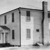
Washington was established as the first county seat in 1824. It was located on the Southwest Trail and, because of its proximity to the border, was a stopover for those traveling west. Sam Houston and Davy Crockett were two of those travelers. James Black reportedly created the original Bowie knife in Washington. The village was on the Trail of Tears for Indian Removal from 1832 to 1838. It was the rendezvous point in 1846 for volunteers to be mustered in to fight in the Mexican War.
Before statehood, wealthy Virginians with plantations on the Red River were building their homes in Spring Hill for educational and social advantages. They established the Spring Hill Female Academy in 1837 and later added a male academy, but competition from Washington, Falcon, and Lewisville academies caused the Spring Hill Academy’s closure. Also during this time, families with few slaves came from Alabama, Mississippi, Georgia, and the Carolinas. Some rented small farms until they could purchase their own, and they started small neighborhood schools and churches.
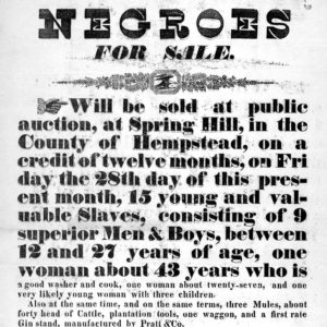
Hempstead County ranked fifth in the slave-owning counties in Arkansas. The U.S. Census for 1850 shows 296 owners and 2,394 slaves, not counting the slaves on the Red River plantations.
Civil War through Reconstruction
The 1860 federal census placed the white population of the county at 8,589 and the enslaved population at 5,398, reflecting the dominance of plantation-style agriculture in the county. Alfred Carrigan and Rufus King Garland represented the county in the 1861 Secession Convention. Carrigan owned at least twenty-one enslaved people at the time of the 1860 census, while Garland owned at least nine.
Following Arkansas’s secession from the Union, Hempstead County provided its share of troops for the Confederacy, and Washington became a refugee center. The closest battle was the Skirmish at Prairie D’Ane, eight miles to the east of Washington, and the wounded were cared for in Washington. Washington also served as the Confederate state capital from 1863 to 1865 when Little Rock (Pulaski County) fell to the Union forces, and the 1836 county courthouse was used for the legislative session. A number of earthworks were constructed near Dooley’s Ferry to protect Washington from an invasion of Federal troops. Washington resident Charles Mitchel briefly served as a U.S. senator in 1861 and then served in the Confederate Senate until his death in 1864.
At the close of the Civil War, the Twelfth Michigan Infantry spent three months in Washington ensuring peace in the county. “The Union soldiers were received by our people in the right spirit…and were extended the usual hospitalities they have been accustomed to show,” wrote Jno R. Eakin, Washington Telegraph editor. Rumors of Ku Klux Klan–related events are probably true, but the county had no race riots or violent events during the Reconstruction years.
The official population increased in these years as the former slaves were listed in the census for the first time as citizens. It is possible that the non-violent atmosphere in the county attracted other former slaves. Also, veterans and others whose lands had been devastated during the Civil War came west looking for a new life. However, tenant farming left both blacks and whites tied to their crops and not much better off.
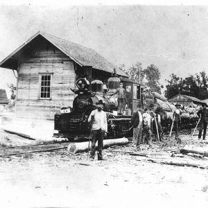
Transportation was necessary for the success of the economy, which was based on cotton and timber. Steamboats moved up and down the Red and Mississippi rivers, transporting cotton to be sold in New Orleans, Louisiana, and returning with merchandise for stores. The first roads had been cut out under the supervision of the county courts, which kept them passable with landowner overseers. Railroads crisscrossed the county beginning with the Cairo and Fulton Railroad, for which the laying of tracks was completed by 1873 when the first steam engine arrived at Fulton from Argenta, now North Little Rock (Pulaski County). The Cairo and Fulton was reorganized as the St. Louis, Iron Mountain and Southern, then became the Missouri-Pacific, and finally the Union Pacific Railroad. A branch of the Missouri-Pacific ran from Hope to Nashville (Howard County). The Louisiana and Arkansas (L&A) ran from Shreveport, Louisiana, to Hope for many years. The Frisco (now the Kiamichi) continues to run from Hope to Oklahoma.
Post Reconstruction through the Gilded Age
A new courthouse was built at Washington in 1874. In 1880, the rich earth near Columbus was producing 1,120 pounds of cotton per acre. Total production of cotton for the county was 13,985 bales, worth an estimated $1.425 million. By 1890, cotton production had increased to 15,985 bales. Cotton continued to be king until after World War I. No cotton is grown in the county today.
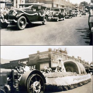
The first chapter of the United Daughters of the Confederacy in Arkansas was chartered in Hope in 1896.
Several incidents of extrajudicial racial violence occurred in the county in the late nineteenth and early twentieth centuries. In 1904, White Jetton allegedly attacked a white farmer near Spring Hill and a mob hanged Jetton in response. Browning Tuggle lost his life in 1921 for allegedly attacking a white woman. The following year, John West was killed after an argument with a white man. Other incidents of lynching took place in 1885, 1909, and 1911.
Early Twentieth Century
With the development of the automobile, good roads were in demand. In 1922, the road from Emmet to Fulton was improved as part of the Bankhead Highway, the first southern transcontinental highway. It ran on the north side of the Missouri-Pacific Railroad. In 1934, the first cars drove on the south side of the tracks on paved Highway 67. Interstate 30 was completed in 1972.
As the railroads developed, Hope became the center of the county and replaced Washington as the county seat in 1939. Fulton’s role as a river town had ceased with the coming of the railroad in 1872, though its ferry across the Red River was in operation until the Highway 67 bridge was completed in 1930. The opening of the bridge caused the decline in use of Dooley’s Ferry, which had been established in 1836 a few miles downriver, south of Fulton.
With the development of a road system, the need for trading areas declined. Some of the older communities include Ozan, Bingen, McCaskill, Wallaceburg, Guernsey, and Clow. Both Shover Springs and Lithia Springs, near Spring Hill, had a recreation area and healing springs. Patmos was located on the Louisiana and Arkansas Railroad and used as a shipping site. Blevins, which was established later, has one of the county’s three school districts.
Camp Alton, a Civilian Conservation Corps (CCC) camp, opened in 1935. It was located on Highway 29 near the Louisiana and Arkansas Railroad station at Alton. It was operated by the U.S. Soil Erosion Service and aided local farmers in a program of soil erosion control. The camp closed in 1942.
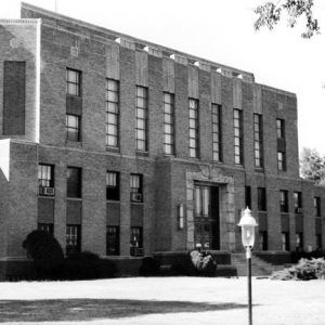
The Arkansas Supreme Court declared Hope the county seat on May 11, 1939, after five bitterly fought elections to move the courthouse from Washington to Hope. The Public Works Administration helped to fund Hope’s courthouse in 1939.
World War II through the Faubus Era
The biggest change in Hempstead County came in 1941 when the federal government constructed the Southwestern Proving Ground, one of the ordnance plants established in the state, on more than 50,000 acres of farmland in the center of the county. Ammunition was tested under the supervision of the Army Ordnance Department, using civilians for most of the work. The plant closed in 1946, but some who moved to the area to work never left. Some of the land was repurchased by original owners, and other land was set aside for industrial development.
A number of homes constructed for officers stationed at the facility were sold to veterans, and the area was incorporated as the town of Oakhaven.
Army Major Paul W. Klipsch was in the ballistics department at the proving ground from 1942 to 1946. He stayed in Hope and eventually began the manufacture of audio speakers. He became known and respected internationally for his products, and Klipsch Audio Technologies continues to make some of the world’s finest concert-quality loudspeakers, speaker systems, and electronic audio products.
When World War II ended, veterans began to return home. This brought on the building of new homes and the opening of several new businesses. Veterans were also successful in their pursuit of county offices.
Desegregation followed the federal guidelines, moving slowly, and was completed in 1972 without incident.
Modern Era
By 1972, when I-30 from Little Rock to Texarkana (Miller County) was completed, Hope’s business district began its move to the interstate area north of the city. When a Walmart Inc. Superstore was located north of the interstate, other businesses followed.
The Graves-Foster Water Treatment Plant at Fulton purifies water from Millwood Lake. It is the source of water for Hope and most of the county.
Following the destruction in New Orleans by Hurricane Katrina in 2005, more than 10,000 trailers were sent to Hempstead County to be delivered to those who had lost their homes. The trailers were never delivered and were stored at the Hope Municipal Airport until 2011.
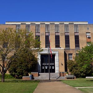
On February 23, 2017, the Hempstead County Quorum Court voted to purchase the three-story Farmers Bank & Trust Building on 200 E. Third Street to serve as the new courthouse, the old one having been deemed unsafe due to mold and asbestos. Voters in 2020 approved a sales tax, to be in effect for two years, to fund renovations, and the grand opening for the new courthouse was celebrated on May 19, 2022.
Industry
From the beginning, the county’s virgin timber was a source of income. Captain Judson Timothy West, who retired to Hope from steamboating in 1876, organized the Hope Lumber Company in 1890. It was one of the largest in the area, shipping finished lumber throughout the northern states. There were other companies, including Ivory-Handle Company, incorporated in 1901, which used hickory timber. Small sawmills dotted the county. Today, most of the hardwoods are gone, and pine is being grown for harvesting.
The University of Arkansas Southwest Branch Experiment Station was founded in 1929 as a fruit and truck station near Hope. In the 1950s, work changed to beef cattle, forestry, and crops other than vegetables, reflecting the needs of the farmers.
Poultry has taken first place in farming in Hempstead County. The county rates in the top ten of broiler growers in the state, and the Tyson poultry processing plant employs more than 700 people. The county is also in the top sixteen of Arkansas counties in cattle raising. Many farmers raise poultry and cattle and grow timber part time.
Attractions
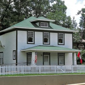
Hope was the birthplace of President William Jefferson Clinton, and his restored home is open to visitors. It became part of the National Park Service and is known as the President William Jefferson Clinton Birthplace Home National Historic Site. The Hope Depot, which was given to the city in 1999, serves as the Hope Visitors Center Depot and Museum. It is operated by the city.
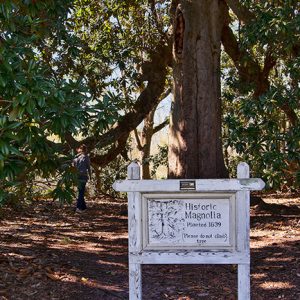
The Rick Evans/Grandview Prairie Wildlife Management Area, established by the Arkansas Game and Fish Commission (AGFC) in 1997, included 4,885 acres on the site of Mound Prairie and its plantations. It represents the largest tract of black land prairie in public ownership in the nation. The land is being allowed to return to its original condition, and there is controlled fishing and hunting on the grounds.
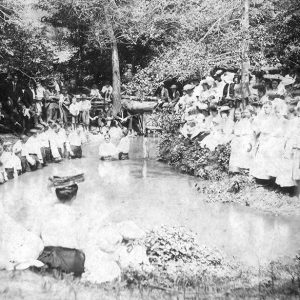
Recreation is also provided by the Dr. Lester Sitzes III Bois d’Arc Wildlife Management Area south of Spring Hill. The Grassy Lake and Yellow Creek clubs are privately owned and are known for their virgin cypress trees and as habitat for alligators. Big Arkie, the largest alligator ever to be captured and held in captivity in the state, was trapped near Hope in 1952. The Millwood Dam and Lake is on the northwest edge of the county and in Little River County. It is popular for fishing and camping.
Historic Washington State Park preserves and interprets the history of Washington. The Southwest Regional Archives, a part of the Arkansas State Archives, preserves a collection of archival materials related to Hempstead and other nearby counties.
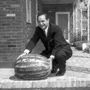
County events include the Historic Washington Jonquil Festival held in March, the Twin Rivers Festival at McNab in April, the Hope Watermelon Festival in August, Frontier Days at Washington in August, the Civil War Weekend at Washington in October, and Christmas in Candlelight at Washington.
Education
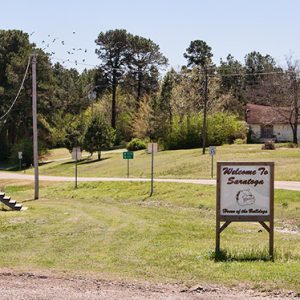
The earliest county schools were by subscription, but by 1870, schools were receiving some state funds along with local taxes. At one time, ninety-five school districts provided separate education for black and white children, but since consolidation and integration, there are only three districts: Saratoga, Blevins (includes Emmet), Springhill, and Hope.
John Williamson established Haygood Seminary north of Washington in 1883 for black teachers, ministers, and musicians. Bowen Seminary, also for black students, was founded at Clow in about 1890 and, in 1930, was replaced with state-sponsored Clow Training School. The town was founded by freed slaves and was once a community of 2,500 black landowners.
The University of Arkansas Hope-Texarkana provides two years of undergraduate as well as baccalaureate and master’s degrees through off-campus programs. It began as Red River Vocational School in 1965, became Red River Technical College in 1991, and in 1996, became a division of the University of Arkansas System; it adopted its current name in 2019.
Famous Residents
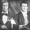
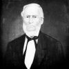
The county has had its share of leaders, in addition to several governors and President Clinton. Clinton’s election in 1992 led to a number of Hempstead County residents taking positions within his administration. Mack McLarty served as chief of staff and Vince Foster served as deputy White House counsel. Grandison D. Royston was an attorney and delegate to the Arkansas Constitutional Convention. Edward Cross was a U.S. representative. Jno Eakin was an editor, attorney, and champion of women’s rights. Captain Judson Timothy West was a steamboat captain and business leader. Black leaders have included Archie Shepperson, an educator, and Henry Clay Yerger, who began the first school for black children in Hope. John Walker led the fight for integration and equitable funding for education in the state for decades. Both Oren Harris and George Lloyd Spencer have served as U.S. congressmen; Harris was also a federal district judge. Republican Sarah Huckabee Sanders, a native of Hope, was elected governor in November 2022.
For additional information:
Biographical and Historical Memoirs of Southern Arkansas. Easley, SC: Southern Historical Press, 1978.
Hempstead Trails. Hope, AR: Hempstead County Genealogical Society (1986–).
The History of Redland Township, Hempstead County, Arkansas. N.p.: 2015.
Houston, Kelly E. “Slaveholders and Slaves of Hempstead County, Arkansas.” MA thesis, University of North Texas, 2008.
Journal of the Hempstead County Historical Society. Washington, AR: Hempstead County Historical Society (1977–).
Medearis, Mary. Washington, Arkansas: History on the Southwest Trail. Rev. ed. Hope, AR: Etter Printing Company, 1984.
Poe, Ryan. “Working Families and the Reconstruction of Hempstead County, Arkansas.” MA thesis, University of Arkansas, 2010.
Mary Nell Turner
Hope, Arkansas
Revised 2022, David Sesser, Henderson State University


There is a site with aerial photos of beginning around 1946 and taken every seven years or so. Some of the pictures are grainy, but you can see individual buildings. Very helpful in my family research. Search for aerial photos. You have to register to use.
I lived in a small community named Deanyville on the Prescott & Northwestern railroad route in 1943. I have been trying to find a map of the place during that time period. It was a sawmill town with a couple of stores. One was run by Hix Loe and one by Milburn Phillips. I can’t remember the name of the owner of the sawmill but, strange as it seems, I remember the horse that pulled the cart carrying the lumber from the mill to be stacked. Her name was Dolly. Ha! I was five years old at the time.