 Tropical Cyclones
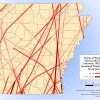
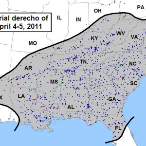 April 2011 Derecho / Area Affected
 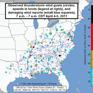 April, 2011 Derecho / Wind Gusts
 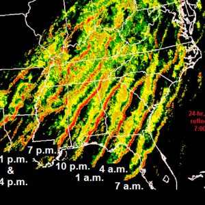 April 2011 Derecho
501-918-3025
calsfoundation@cals.org
calsfoundation@cals.org
While Arkansas makes national news far more often for its tornadoes, the state suffers its fair share of what are commonly known as straight-line winds. For example, on June 5, 2014, a weather event originating in Colorado crossed northeastern Arkansas, killing two people, derailing a train in Craighead County, and leaving thousands without power.
A derecho (pronounced “deh-REY-cho”) is an event that consists of winds that create a swath of damage that extends for more than 240 miles, has minimal wind gusts of at least fifty-eight miles per hour (mph) for most of this swath, and includes multiple hurricane-force (seventy-five mph or greater) gusts. Derechos originate from what are commonly called “bow echoes,” named for their curved radar signature. About half of these echoes are produced, often in the Great Plains, from disorganized areas of showers or thunderstorms; the rest are either embedded within squall lines (or quasi-linear convective systems) associated with cold fronts or originate from supercell thunderstorms, which are storms that have a persistent rotating updraft that generates tornadoes and large hail, in addition to the extreme winds. All of these systems can produce downbursts of heavy, rain-cooled air. This rapidly sinking air, moving at speeds up to 150 mph, concentrates in a single direction, creating the bowed radar structure—the “point” (apex) of the bow representing the fastest-moving portion of the downbursting wind. The storms generally move forward, with cold air forcing warm moist air up in advance, weakening and regenerating across large areas.
If this goes on long enough with little distance or time between regeneration, the result is a derecho; however, single downbursts can cause severe damage, and it is not necessary for a storm to be especially large or strong to have violent downbursts. Small areas within downbursts, called “microbursts,” often reach higher wind speeds than the surrounding downburst. Often, a mesoscale convective complex/system (a self-perpetuating mass of storms sometimes equal in area to an entire state or larger) is formed, with bow echoes at the leading edge. While the term “rogue wind” is not official National Weather Service lingo, it is an apt moniker for unexpectedly strong winds not related in any way to convective activity (i.e., thunderstorms) that occasionally cause a great deal of damage, injury, and even fatalities. Arkansas is frequently affected by all manner of these straight-line winds.
Derechos in Arkansas
Northwestern Arkansas is part of the most derecho-ridden zone in the United States, experiencing more than one moderate-to-strong derecho per year. Between 1980 and 2001, this area was affected by thirty derecho events (a majority occurring between May and August), while the southeast corner of the state suffered twenty-seven (a majority of these between September and April); much of the rest of the state experienced around twenty-four.
The state is most affected by serial derechos, occurring most often in spring and fall, generally associated with squall line–embedded bows. This structure often affects very large areas, as the squall line itself can be 100 or more miles long. In contrast, progressive derechos are relatively narrow, forming from small clusters of storms, often along a stationary front aligned generally east-west. Storms spreading along this front sometimes cover incredible distances, from the Great Plains to the Atlantic Ocean. Progressive derechos are difficult to forecast, as large-scale conditions can be hard to detect.
Arkansas ranked eighth in the nation in derecho fatalities per 100,000 people during the period from 1986 to 2003; the state’s low population density is likely responsible for a surprisingly small number of fatalities and injuries, as only four people perished in derecho events during that period. Many derechos occur at night, when people are safely indoors, although many straight-line wind injuries and fatalities are related to trees falling on homes and vehicles.
The fact that Arkansas is often a source region for derechos that devastate parts of neighboring or even distant states might also explain lower injury/fatality rates, as storms forming in Arkansas often do not reach their full fury until after crossing the Mississippi River. Such was the case in several notable derecho events, such as on April 9, 1991, when a derecho, named for its damage to distant West Virginia, formed over Pulaski County; no Arkansans were injured or killed. On July 22, 2003, a derecho began at 1:00 a.m. in Benton County and exited Crittenden County, where many tractor-trailers were blown over and twenty mobile homes damaged. Neighboring Memphis, Tennessee, bore the brunt of this storm; nearly a million people were without power at its height, 100,000 for more than ten days.
The “Super Derecho” of May 8, 2009, nicked northern Arkansas. It is one of the more unusual weather events ever recorded, producing an intense mesoscale vortex just across the Missouri border, with a rare hurricane-like eye structure. All told, this storm traveled 1,000 miles from its start as a collection of rain showers in Colorado.
More high-wind reports were recorded in Arkansas during the June 12, 2009, derecho than any other day on record—118. Many of the winds were over eighty mph. While only two people were injured, damages exceeded $5 million. A particularly busy year for derechos was 2004—March 4, May 30, and July 4 were notable dates, although no fatalities/injuries were reported in any of these events.
Wind-Related Events of April 2011
April 2011 is a month that stands out as one of the most violent in Arkansas and the rest of the country. In state, four major wind-related events occurred. Beginning on April 4, a derecho commencing in Searcy County around 6:00 a.m. produced some of highest winds ever estimated in Arkansas, reaching 100 mph in Ashdown (Little River County) and Hope (Hempstead County). This derecho injured only three people, despite ten reports of winds exceeding hurricane force.
A second multi-bow derecho occurred on April 19, in which three separate large bow echoes affected the state. The first, forming over northwestern Arkansas, and the third, in the southeastern corner, did little damage in the state. The second, however, began as several supercell thunderstorms merged near Little Rock (Pulaski County), bringing a gust of ninety-five mph recorded in Oil Trough (Independence County); many gusts from sixty to eighty mph cut through the entire center third of the state, southwest to northeast, although no one in the state was injured.
That was not the case in a third major event that month—not officially listed as a derecho despite crossing the entire state with multiple bow echoes: On April 14–15, the deadliest non-tornado day recorded in the state, six people were killed by trees falling on homes and RVs; one more person died in a rolled mobile home. The fact that the state had had an extremely wet month contributed to the tree falls.
In the final major event of that month, many wind/damage reports accompanied the statewide tornado outbreak of April 25–27. No fatalities or injuries were reported in straight-line winds, however. All in all, April 2011 saw a grand total 230 reports of violent winds, with storms producing over $6.5 million in damage not associated with tornadoes.
Convective Wind Statistics
National Climate Data Center (NCDC) reports since 1950 show 2,140 days with “reportable” thunderstorm-related winds out of 23,735 total days, meaning that they occur on nine percent of all days. These figures include both derecho and non-derecho events. The criteria for what is “reportable” have changed over the years, however; today, fifty-eight mph is considered “severe,” and spotters report wind damage rather than estimate speeds. Despite this high frequency, however, no Arkansas deaths were reported from high winds during the first thirty-four years of the period, and only twenty-one fatalities have been attributed to all convective wind events since 1950. A total of 239 injuries were recorded since 1950 in non-tornadic winds. These figures are quite low for the number of events cited and the fact that well over $100 million in damage was recorded.
Record Winds
The highest recorded wind speed associated with convective (thunderstorm) activity was clocked at the Corning Airport in Clay County at 103 mph on April 9, 2009, a day on which twenty-eight counties in Arkansas suffered damage worth over $1 million, but producing only one injury. The strongest estimated thunderstorm-related winds are about 115 mph, reported on May 16, 2003, in Waldenburg (Poinsett County) and in Marvell (Phillips County) on January 22, 2012.
“Rogue” Winds
Interestingly, thunderstorm winds and non-convective (or “rogue”) winds have caused similar twenty-five-year (1980–2005) fatality totals in the United States (696 thunderstorm-related; 612 non-convective); only two fatalities occurred in Arkansas during the same period. Most non-convective fatalities occur in areas of intense barometric pressure differences and associated frontal passage. The NCDC database reveals that Arkansas experienced only forty-eight days (out of 23,407 total days) with high or strong winds not associated with convection, six of those with fatalities.
One notable “rogue wind” event occurred in Arkansas on January 29, 2008. A cold front slammed into Arkansas, and a very large barometric pressure fall/rise on either side of this front resulted in an extreme pressure gradient and very quick turnaround of strong wind from southwest to northwest. More than sixty reported high-wind events resulted in two fatalities (in Faulkner and Lonoke counties). Measured winds reached sixty-one mph at the Little Rock Air Force Base; damage was estimated at over $13 million, and more than 80,000 Arkansans lost power in this most unusual single event.
For additional information:
“About Derechos.” Storm Prediction Center http://www.spc.noaa.gov/misc/AbtDerechos/derechofacts.htm (accessed September 16, 2021).
Ashley, Walker S., and Alan W. Black. “Fatalities Associated with Nonconvective High-Wind Events in the United States.” Journal of Applied Meteorology and Climatology 47 (February 2008): 717–725. Online at http://journals.ametsoc.org/doi/pdf/10.1175/2007JAMC1689.1 (accessed September 16, 2021).
Henson, Bob. “Derechos in DC: Science and Surprise.” AtmosNews. University Corporation for Atmospheric Research. http://www2.ucar.edu/atmosnews/perspective/7424/derecho-dc-science-and-surprise (accessed September 16, 2021).
Knox, John A., et al. “Death from a Clear Blue Sky: Extreme Non-Convective High Winds,” Earthzine, June 4, 2011. http://www.earthzine.org/2011/06/04/death-from-a-clear-blue-sky-extreme-non-convective-high-winds/ (accessed September 16, 2021).
National Weather Service in Little Rock. https://www.weather.gov/lzk/ (accessed September 16, 2021).
Storm Events Database. National Climate Data Center. http://www.ncdc.noaa.gov/stormevents/ (accessed September 16, 2021).
Mary Sue Passe-Smith
University of Central Arkansas


Comments
No comments on this entry yet.