 Anderson Flat (Marion County)
 Carroll, Marion, and Searcy Counties, Scout to
 Caulder, Peter
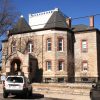 Marion County Courthouse
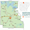 Summit (Marion County)
 Turnbo, Silas Claiborne
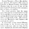 Tutt-Everett War
 Wishbone Cutter
 Bruno
Bruno  Bull Shoals Dam
 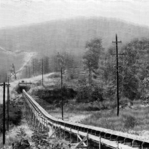 Bull Shoals Dam Conveyer Belt
 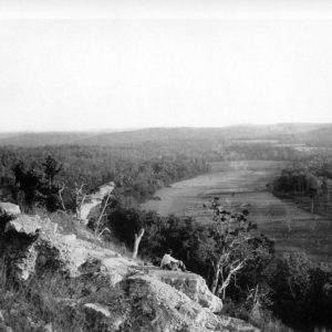 Crooked Creek
 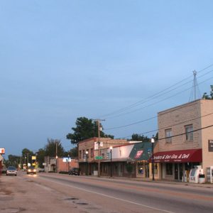 Flippin Street Scene
 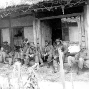 Charles Gilliland
  Marion County Courthouse
 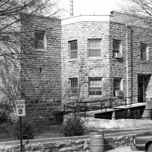 Marion County Courthouse
  Marion County Map
  Francis Marion
 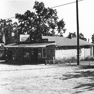 Milligan's Store
 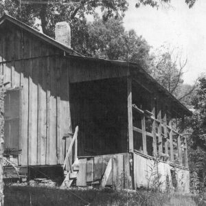 Old Courthouse in Rush
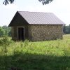
 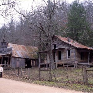 Rush Ghost Town
  Ruby Starr
501-918-3025
calsfoundation@cals.org
calsfoundation@cals.org
| Region: | Northwest |
| County Seat: | Yellville |
| Established: | September 25, 1836 |
| Parent County: | Izard |
| Population: | 16,826 (2020 Census) |
| Area: | 596.65 square miles (2020 Census) |
Historical Population as per the U.S. Census:
|
1810 |
1820 |
1830 |
1840 |
1850 |
1860 |
1870 |
1880 |
1890 |
1900 |
|
– |
– |
1,325 |
2,308 |
6,192 |
3,979 |
7,907 |
10,390 |
11,377 |
– |
|
1910 |
1920 |
1930 |
1940 |
1950 |
1960 |
1970 |
1980 |
1990 |
2000 |
|
10,203 |
10,154 |
8,876 |
9,464 |
8,609 |
6,041 |
7,000 |
11,334 |
12,001 |
16,140 |
|
2010 |
2020 |
|
|
|
|
|
|
|
|
|
16,653 |
16,826 |
|
|
|
|
|
|
|
|
| Population Characteristics as per the 2020 U.S. Census: | ||
| White |
15,569 |
92.5% |
| African American |
20 |
0.1% |
| American Indian |
138 |
0.8% |
| Asian |
56 |
0.3% |
| Native Hawaiian or Other Pacific Islander |
5 |
0.0% |
| Some Other Race |
77 |
0.5% |
| Two or More Races |
961 |
5.7% |
| Hispanic Origin (may be of any race) |
379 |
2.3% |
| Population Density |
28.2 people per square mile |
|
| Median Household Income (2019) |
$36,719 |
|
| Per Capita Income (2015–2019) |
$21,395 |
|
| % of Population below Poverty Line (2019) |
18.2% |
|
Marion County is located in north-central Arkansas on the Missouri border, within the Ozark Mountain range. The White River, the Buffalo River, Crooked Creek, and the Little North Fork of White River are the county’s principal streams. The county’s topography ranges from Kings Prairie in the southwestern portion of the county to the mountainous regions in the north. Chief agricultural products through the years have included cotton, tomatoes, and beef and dairy cattle. Lumber, including pine, cedar, and hardwoods, has also been exported from Marion County.
Pre-European Exploration through European Exploration and Settlement
Spear point finds indicate that early humans hunted animals native to the Ozark Plateau, including what is now Marion County, as early as 12,000 years ago, although no evidence of permanent occupation by Pleistocene peoples has been discovered. The first inhabitants of the area were Native Americans once broadly categorized as the “Ozark Bluff Dwellers,” but which actually included various groups from the Archaic, Woodland, and Mississippian periods. By the time the first European explorers arrived, the Osage maintained a number of seasonal hunting camps throughout the Ozarks.
It is not known for certain when the first Europeans visited the area now known as Marion County. Tradition has it that Spanish explorer Hernando de Soto and his party came as far north as present-day DeSoto Springs, located in the southern part of the county, sometime during the winter of 1541 and camped there; however, anthropologist Charles Hudson’s re-creation of the expedition’s path does not show the path as going through Marion County.
Louisiana Purchase through Early Statehood
The first white person believed to have been born in Marion County was A. S. “Uncle Bud” Wood, son of William Wood who moved from Tennessee to Marion County as a young man between 1815 and 1820. One of the earliest families of white settlers in Marion County consisted of Mike Yocum and his three brothers, Jess, Solomon, and Jake. These four men came to America from Germany in the 1820s or 1830s and settled at the mouth of the Little North Fork of White River. Mike Yocum owned a mill there.
Marion County was created in 1835 from a portion of the western part of Izard County, although it was immediately renamed Searcy County by the Territorial General Assembly. On September 29, 1836, the First General Assembly of Arkansas received a petition from the county requesting the name be reverted to Marion County, to which the assembly agreed. The new county was named in honor of General Francis Marion, a Revolutionary War general, referred to by the British as the “Old Swamp Fox.”
A temporary county seat was established in the home of Thomas Adams, which also served as the county’s first courthouse. The county seat was soon moved to Yellville, due both to the town’s central location and the fact that it was situated on the military road from Batesville (Independence County) to Fayetteville (Washington County). For unknown reasons, the county seat was moved temporarily in 1870 to the small town of Sherman, located on the White River. It was soon returned to Yellville, where it has remained.
Yellville was created when white Americans appropriated the cleared land and settlement of Shawneetown, which was abandoned by Shawnee Indians in 1832. A group of Shawnee had founded Shawneetown on the White River after being invited to relocate to the Ozarks by the Western Cherokee in 1817.
A significant free African American population existed in Marion County beginning with David Hall, who moved from Tennessee with his family and settled on the White River, near the mouth of the Little North Fork, around 1819. Peter Caulder, a free man of color who served in the U.S. Army at Fort Smith (Sebastian County), married Hall’s daughter and lived in the county. The 1850 federal census listed 129 free Blacks and 126 slaves in Marion County, meaning that African Americans made up twelve percent of the county’s population. Until passage of the short-lived Act 151 of 1859, mandating the expulsion of free Blacks from the state, there existed for three decades little discord between the white and Black populations of the county. By late 1860, however, the free Black population had shrunk to eight.
Political disputes roiled the county in the 1840s, leading to the Tutt-Everett War. The conflict would eventually claim at least fourteen lives.
Civil War through the Gilded Age
Like in other border counties in northern Arkansas, the citizens of Marion County owned few slaves and were generally opposed to secession. By late summer 1861, however, the county’s first infantry company was formed under Captain J. R. Dowd. As more and more men were recruited and left home, the county saw an influx of men from other areas who sought to evade service and, banding together, began to plunder the largely defenseless homes and farms. These bushwhackers, along with groups of Union soldiers in the county after the Battle of Pea Ridge, wrought vast devastation. A skirmish was fought at Talbot’s Ferry as Union troops were moving eastward after Pea Ridge.
Salt Peter Cave, near Fairview, was an important asset for Confederate forces due to its rich deposits of nitrate. A gunpowder production facility constructed at the cave was destroyed by Union forces at least twice. Yellville became strategically important to both Confederate and Union forces due to its location at the junction of two roads and its proximity to the nitrate deposits and Talbot’s Ferry, the primary crossing of nearby White River. The town was occupied at various times by both forces and was controlled during the winter of 1864–65 by a large band of bushwhackers. By the end of the war, Yellville had been almost completely destroyed by fire.
Rebuilding Yellville and the rest of the county happened slowly during Reconstruction. Stores returned to the communities, and schools began to be opened, including a Male and Female Academy, opened by the Methodist Church in Yellville in 1888, and the Yellville School (first called Yellville College, but never intended as an institute of higher education) two years later.
The population of the county grew dramatically when valuable metal ores began to be mined late in the nineteenth century. Mining, chiefly for lead and zinc, led to the creation of miners’ communities throughout the county, but especially in the Rush Creek area. Demand for these metals peaked during World War I, after which competition from overseas led to the collapse of the mining industry in northern Arkansas.
Early Twentieth Century
The railroad first came to Marion County early in the twentieth century, as the Iron Mountain Railroad crossed the area, with stops in Flippin, Yellville, and Pyatt. Several banks also opened in Yellville and Flippin. The first electricity generated in the county was at Blue Moon Mining, which in 1914 supplied power not only to its own facilities but also to the Elkhorn Hotel in Kingdon Springs. Ike Emery’s businesses in Yellville installed an electric generator in 1916 and supplied residential electric power, but only between sunset and 11:00 p.m. Flippin first gained electric power in the 1920s.
When the mining industry declined, people began to leave Marion County, seeking jobs elsewhere. The Great Depression increased the exodus from the county. Several banks in Yellville and Flippin closed, and some stores went out of business. The Civilian Conservation Corps (CCC) was active at Buffalo State Park (land later occupied by the Buffalo National River) and in a small soil conservation project in the community of Eros. Most of those who joined the CCC found themselves employed elsewhere in the region, such as in Russellville (Pope County) or Mountain Home (Baxter County). The Works Progress Administration constructed the Eros School Building and the Cold Springs School around 1935, while the National Youth Administration constructed a school in Flippin. Some county residents made money by digging for mussel shells and even occasional pearls in the White River, as well as growing herbs. Cotton had been a principal crop of Marion County since steamboats first came up the river in the nineteenth century, but tomatoes and fruits replaced cotton as the primary crops of the county.
World War II through the Modern Era
During World War II, tomatoes continued to be a main crop in Marion County. The federal government purchased tomatoes from several farmers to feed American soldiers. After the war ended, the industry faltered. An attempt to grow strawberries in the southern part of the county similarly failed. Eventually, most of the agricultural land was converted to pasture or to fields of hay to support a growing cattle industry.
The population decline continued after the war, as many soldiers failed to return home. Some were battlefield casualties, but most were men who found better job opportunities outside the county. Hope to reverse this trend centered on a new pair of industries: tourism and recreation. Bull Shoals Dam was begun in 1947 and completed in 1951. At the time, it was the fifth-largest concrete dam in the United States. This dam not only controls flooding in the White River valley but also maintains Bull Shoals Lake, which offers opportunities for recreation, including boating, fishing, and other water sports. (The lake also splits the county in two, so that residents in the northeast corner have to drive through Baxter County to reach the county seat.) The tourist attraction of Mountain Village 1890 was created at this time in the city of Bull Shoals. A re-creation of a late-nineteenth-century Ozark town, the village became a popular tourist attraction, as well as a frequent destination for school field trips. Another popular area attraction is the Bull Shoals Caverns, a set of caves in the limestone underlying the Ozark Mountains of the county.
Like many counties in the Ozarks, Marion County had a small-to-non-existent African-American population throughout the twentieth century. As a consequence, school desegregation struggles in much of the state did not have an impact on Marion County. On the other hand, Marion County received some unfortunate notoriety in the 1980s when federal authorities raided the Zarephath-Horeb compound of a white supremacist group calling itself “The Covenant, the Sword and the Arm of the Lord.” Describing themselves largely as a religious and survivalist organization, they were found to possess guns, other weapons, and poison. Their membership was never much higher than 100, and the organization dwindled into obscurity following the 1985 raid.
The county was also the site of the ill-fated Whitewater Development, which eventually was a focus in the investigation and impeachment of President Bill Clinton.
In the twenty-first century, the major towns of Marion County are Yellville, Flippin, Pyatt, Bruno, Peel, Oakland, Summit, and Bull Shoals. The population of Marion County has been slowly increasing and stands at nearly 17,000 as of the 2020 census. The county has three public schools: Yellville Summit, Flippin, and Bruno Pyatt. The major newspaper of the area is the Mountain Echo, which has been in operation since March 5, 1886.
Industry
Several agricultural products are found in Marion County. Jefferson watermelons are a summer favorite. Hay is grown as a feed crop for beef cattle. Several turkey farms are located within the county, and most turkeys are sold at maturity to McClain Farms in Mountain Home. A few fruit orchards dot the area. Flippin is home to Ranger Boats, founded by Forrest Lee Wood, the major industry of the area. Other major employers have been Micro Plastics, MarBax Shirt Factory, and the St. Louis Music Company.
Attractions
Marion County boasts many streams and springs, as well as natural hunting areas full of deer, turkeys, squirrels, and even a few bears. Buffalo National River and Bull Shoals Lake (including Bull Shoals-White River State Park) account for much of the tourism income for the area. Crooked Creek is a particularly popular floating and fishing stream for locals. In October of each year, Yellville hosts the annual festival known as Turkey Trot and the National Wild Turkey Calling Contest. The Miss Turkey Trot Pageant and the Miss Drumsticks Leg Contest are major events of the festival. A controversial issue associated with Turkey Trot has been the traditional turkey toss in which live turkeys are thrown from an airplane to the crowd below.
Several buildings are listed on the National Register of Historic Places, including the Estes-Williams American Legion Hut 61 and the Marion County Courthouse. The ghost town of Rush is also listed.
Well-known residents of the county include Silas Turnbo, who collected stories from Ozark families, and author Richard Sharpe Shaver.
For additional information:
Berry, Earl. History of Marion County. Little Rock: International Graphics Industry, 1977.
Burleson, Floyd. Treasured Memories of the North Arkansas Hills. Yellville, AR: Carrousel Publishing Company, 1989.
Jones, W. B. Gleanings of Pioneer History. Self-published, n.d. On file at the Marion County Library, Yellville, Arkansas.
Turnbo, Silas. Turnbo’s Tales of the Ozarks: War and Guerrilla Stories. Conway, AR: Rapid Rabbit Copy Company, 1987.
Sherry Sanders-Gray
West Memphis, Arkansas
Staff of the CALS Encyclopedia of Arkansas
Revised 2022, David Sesser, Southeastern Louisiana University


Comments
No comments on this entry yet.