 Historic Preservation
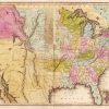 Louisiana Purchase through Early Statehood, 1803 through 1860
 Transportation
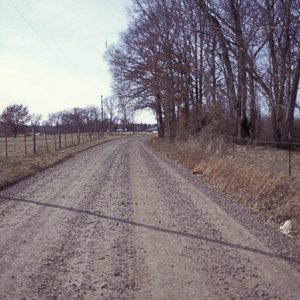 Gibson Road—Fourth Street
 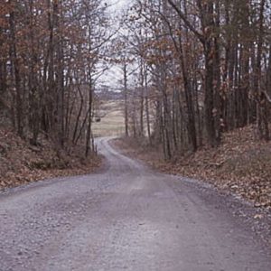 Old Wire Road
 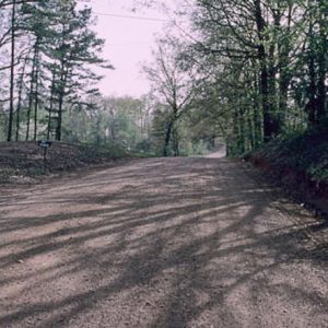 Short Mountain Road
501-918-3025
calsfoundation@cals.org
calsfoundation@cals.org
The Little Rock to Cantonment Gibson Road was constructed between 1825 and 1828 to connect Little Rock (Pulaski County) and Fort Smith (Sebastian County) to the military post at Cantonment Gibson in the Indian Territory (modern-day Oklahoma). The road was used extensively during the forced removal of Native Americans from the southeastern United States to the Indian Territory during the 1830s.
On March 3, 1825, Congress approved a bill to establish a road from Little Rock to the Indian Territory, continuing the Memphis to Little Rock Road between the Mississippi River and Little Rock that was authorized a year before. In addition to the $10,000 funding, Congress appointed Arkansas pioneers Benjamin Moore of Crawford County, Morgan Magness of Independence County, and Edward McDonald of Lawrence County as commissioners to survey and mark a road between Little Rock and Cantonment Gibson.
In early October, the commissioners outfitted an expedition to develop a route for the road, returning on December 17, 1825. The selected route would travel south of the Arkansas River from Cantonment Gibson to Dardanelle (Yell County), at which point it would cross to the north of the Arkansas River to continue on toward Little Rock, avoiding Petit Jean Mountain and its surrounding bayous. The total distance of the road was estimated at “208 miles, 7 chains, and 72 links.”
The commissioners’ report was sent to Washington DC in the spring of 1826, and the Arkansas Gazette reported on March 15 that Colonel Matthew Arbuckle, commander of Cantonment Gibson, “has been ordered, by the Secretary of War, to employ a part of the troops under his command, in opening the road from Little Rock to Cantonment Gibson. The work is to be commenced immediately, and I hope, will be completed in the course of the next summer.”
Arbuckle, however, was still in the process of building the cantonment near the point where the Neosho and Verdigris rivers join with the Arkansas. He reported that he lacked an officer to lead a road-building detail, a physician to accompany it, and enough enlisted men to provide a labor force. Arbuckle also contended that the proposed road was of little use to the army, except where it linked Fort Smith with Cantonment Gibson. By November 16, 1826, however, Lieutenant James L. Dawson, an assistant quartermaster general, was sent to Cantonment Gibson, where he reported that “the Commandant of the Post has notified me that he will be enabled by the advanced State of the Works, to detail the Number of Men, requisite for opening the road from this to Little Rock, in the Course of a few weeks, which will accordingly be commenced.”
Both Dawson and Arbuckle stridently opposed the route between the two military bases as proposed by the commissioners, with Dawson reporting to Washington that “it is not only 10 Miles longer than is Necessary, but passes over exceedingly rough Country, and Crosses all the Water Courses So Near their outlets, as Not to admit of their being forded in Wet Seasons.” Dawson selected a more sensible route, and soldiers from Cantonment Gibson commenced work in the spring of 1827 after Arbuckle received a blunt order directly from the General in Chief to start building the road. Dawson also received orders to seek proposals for contracts to construct the road between Little Rock and Fort Smith.
Dawson placed a request for proposals in the Arkansas Gazette on July 3, 1827, asking that the proposals be made for twenty-nine five-mile increments to link Little Rock and Fort Smith following the route laid by the commissioners. Arbuckle, meanwhile, reported to the Adjutant General in Washington that his troops “will, it is believed, finish the road as far as Fort Smith, in all the present Month; or early in the next.”
On August 28, 1827, Dawson reported that he had completed contracts for the road between Little Rock and Fort Smith, that Arbuckle’s troops had completed their section, and that a “Considerable part of this distance has been opened by the County of Crawford, and the remainder being principally prairie land, will render the Completion of the intermediate portion, a work of little difficulty.…The whole route will be completed by the end of the Current year.” The lieutenant estimated that $4,900 would be needed to build six bridges along the route, nearly three times the amount predicted by the commissioners, and that the contracts for the five-mile increments would total $6,096. Adding another $1,250 for extra laborers, the construction job, minus the bridges, would cost $7,346, using the remainder of the congressional appropriation for the road.
On New Year’s Day 1828, Arbuckle reported that the U.S. Army troops from Fort Gibson had completed their labors, and the Arkansas Gazette reported a week later that the “whole of the road from this place to Cantonment Gibson is completed, with the exception of 35 miles, which will be immediately put under contract.” Dawson reported on January 10 that the thirty-five miles in question were under contract and would “be under operation in a few days, to be completed on the 30 April.” The Military Road between Little Rock and Fort Gibson in Indian Territory was considered basically complete in early 1828. Members of the Creek (Muscogee), Chickasaw, Cherokee, Seminole, and Choctaw tribes would all traverse the Little Rock to Cantonment Gibson Road during the Indian Removals of the 1830s.
Four surviving sections of the Little Rock to Cantonment Gibson Road have been listed on the National Register of Historic Places: the Military Road—Cadron Segment in Faulkner County (listed on January 28, 2004); the Little Rock to Cantonment Gibson Road—Old Wire Road Segment near Blackwell in Conway County (listed on March 27, 2008); the Little Rock to Cantonment Gibson Road—Fourth Street Segment near Atkins in Pope County (listed on January 22, 2009); and the Little Rock to Cantonment Gibson Road—Short Mountain Road Segment near Paris in Logan County (listed on January 4, 2008).
For additional information:
American Native Press Archives. Sequoyah Research Center. University of Arkansas at Little Rock, Little Rock, Arkansas.
Carter, Clarence E., comp. and ed. Territorial Papers of the United States, XX, Arkansas Territory, 1825–1829.Washington DC: Government Printing Office, 1954.
Foreman, Grant. Indian Removal: The Emigration of the Five Civilized Tribes of Indians. Norman: University of Oklahoma Press, 1972.
“Little Rock to Cantonment Gibson Road—Fourth Street Segment.” National Register of Historic Places nomination form. On file at Arkansas Historic Preservation Program, Little Rock, Arkansas. Online at http://www.arkansaspreservation.com/National-Register-Listings/PDF/PP0276.nr.pdf (accessed October 13, 2021).
“Little Rock to Cantonment Gibson Road—Old Wire Road Segment.” National Register of Historic Places nomination form. On file at Arkansas Historic Preservation Program, Little Rock, Arkansas. Online at http://www.arkansaspreservation.com/National-Register-Listings/PDF/CN0342.nr.pdf (accessed October 13, 2021).
“Little Rock to Cantonment Gibson Road—Short Mountain Road Segment.” National Register of Historic Places nomination form. On file at Arkansas Historic Preservation Program, Little Rock, Arkansas.
“Military Road—Cadron Segment.” National Register of Historic Places nomination form. On file at Arkansas Historic Preservation Program, Little Rock, Arkansas.
Nichols, Cheryl. “Construction of the Military Road between Little Rock, Arkansas, and Fort Gibson, Oklahoma.” Research report for the Arkansas Historic Preservation Program, May 2003. On file at Arkansas Historic Preservation Program, Little Rock, Arkansas.
Paige, Amanda L., Fuller L. Bumpers, and Daniel L. Littlefield Jr. “The North Little Rock Site on the Trail of Tears National Historic Trail: Historical Contexts Report.” National Park Service, June 15, 2003. http://www.nps.gov/trte/parkmgmt/upload/North%20Little%20Rock
%20Site%20Report%2080303.pdf (accessed October 13, 2021).
Mark K. Christ
Arkansas Historic Preservation Program


Comments
No comments on this entry yet.