 Historic Preservation
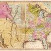 Louisiana Purchase through Early Statehood, 1803 through 1860
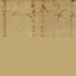 Fort Smith to Jackson Road
501-918-3025
calsfoundation@cals.org
calsfoundation@cals.org
The Fort Smith to Jackson Road was one of several “military roads” the U.S. Congress funded during the 1830s to improve transportation in territorial Arkansas. A Baxter County segment of the road over which the John Benge detachment of Cherokee traveled in 1838 during the Trail of Tears was listed on the National Register of Historic Places on September 22, 2004.
On November 1, 1833, the Arkansas Territorial Assembly petitioned Congress to finance a road across northern Arkansas on the grounds that in “an immense extent of country, situated in the upper waters of White River comprising the counties of Lawrence, Izard and Washington, there is no great public road leading through any portion thereof [and the petitioners] would therefore suggest the propriety, and ask the passage, of an act to open a road from Jackson in Lawrence County by the way of the seats of Justice in Izard and Washington Counties to old Fort Smith on the Arkansas River.…It is believed that an appropriation of twenty five thousand dollars would open the road.” Congress approved funding on June 30, 1834, for construction of a road “from Jackson, Lawrence Co., by Liberty and Fayetteville, Washington Co., to Fort Smith.” Far from the $25,000 suggested for the Fort Smith to Jackson Road, the legislators approved only $10,000 for both “a road from Helena to the Mouth of Cache, and from Jackson, via Liberty and Fayetteville, to Fort Smith.”
Lieutenant Richard D. C. Collins was sent to Arkansas to oversee the project, and he reported on April 14, 1835, that he was preparing to “commence the location and survey of the routes from Strongs on the St. Francis to Batesville and from Jackson, Lawrence County to Fort Smith.” He announced on May 26 that he had “made the necessary examinations to enable me to survey and locate roads from St. Francis to Batesville and from Jackson to Fort Smith—I will be able to finish the survey of them and return to Little Rock by the 1st July, when I will immediately commence work upon them.” Collins estimated that the route from Jackson to Fort Smith (Sebastian County) would cost $25,000, and he wrote on July 5, 1835: “I have made arrangements to commence work on the Ft. Smith and Jackson road as soon as the crops are laid by that laborers can be procured.”
On July 14, 1835, the Arkansas Gazette published a detailed description, provided by surveyor Allen Martin of Pulaski County, of the route the new road would take. Beginning at Fort Smith, the road crossed the Arkansas River at Van Buren (Crawford County), proceeded to Fayetteville (Washington County), then turned east, crossing the White River at Three Forks, the War Eagle Fork of White River, Kings River, Osage Fork of King’s River, Long Creek, two crossings of Crooked Creek, and then “recrosses White river at Talburt’s Ferry, near the end of the 163rd mile.” It then proceeds to cross the Big North Fork of the White at Liberty, then the Strawberry and Spring rivers before ending at Jackson “at the end of the 250th mile.” Martin contended that “for a road of its length, and leading over the most rocky country I ever saw, there are fewer rocks on its line than could almost possibly have been expected. There is generally a pavement of flints from one end to the other, and it runs through the best-watered, and one of the most healthy, regions of country that I have ever seen.”
Collins reported on December 2, 1835: “I have opened the road from Fort Smith to Jackson 70 miles,” and on January 8, 1836: “I have opened and entirely completed the road from Jackson in the direction of Fort Smith 78 miles. The road is for a new one extremely good—It now intersects the old road leading to Fayetteville and Fort Smith at the crossing of the North fork of White river—and will be of great advantage to the country even should no new appropriation be made to complete it, as it opens a direct route from the eastern parts of Arks. to Washington County the most populous in the Territory.…As the part of the appropriation intended for that road is nearly expended, I have thought it best to discontinue work on it for the present.” Attempts to continue work on the road continued after Arkansas achieved statehood in 1836, with U.S. Senator William S. Fulton pursuing funding and arguing to the Senate Committee on Roads and Canals that “it will not be possible to have finished unless it is done at the expense of the United States.”
This road is mentioned prominently in “Old Roads in North Arkansas,” an article by W. E. McLeod published in the spring 1978 Lawrence County Historical Quarterly—an article that may be the best document describing the many different roads through the northern part of the state that went under the moniker Military Road. In that article, McLeod stated: “The other branch of the Military Road extended westward from Jackson to Northfork and on to Batesville and Fort Smith. This was the road used in the removal of the Indians to the west, and by immigrants in Northwest Arkansas.” This information conforms with Collins’s circa 1835 map of the Fort Smith to Jackson Road. The David Burr Postal Map of 1839 categorizes the road between the Izard County Courthouse (then Athens) and Johnston (Marion County) as being a “1 horse mail or sulkey road.”
A Confederate map of the state of Arkansas shows that much of the road between Jackson and Athens had survived into the 1860s. From Athens, it clearly crosses the North Fork of the White River at what W. B. Flippin, who wrote a series of articles on Marion County history in the Mountain Echo newspaper in 1899, had called Middleton’s Ferry, and then continues northwest to cross the White at what was marked on the map as Johnston—the location of Talbert’s Ferry.
A 1998 Arkansas Archeological Survey Report prepared by Larry Billings of Cotter (Baxter County) documents the old Military Road from Buford Road in Gassville (Baxter County) to Talbert’s Ferry. According to Billings, the road followed U.S. Highway 62 from Gassville, then veered northwest to cross a modern pasture and descend the hillside toward Talbert’s Ferry. Much of Billings’s information came from Elmo Hurst, who had lived in the area since his birth in 1909 and said that the road segments were “known as the Trail of Tears Road.”
It is for its connection with Indian Removal that a segment of the road near modern-day Cotter was listed on the National Register of Historic Places. A detachment of Cherokee under Captain John Benge followed a route that traversed northern Arkansas, and they most likely traveled the surviving sections of the Fort Smith to Jackson Road at Talbert’s Ferry in late December 1838.
Twenty-one-year-old W. B. Flippin was assisting the ferryman when the Benge Detachment arrived at the ferry across the White River. He noted, “Many of the Cherokees were well dressed and riding good horses….[But] the majority, many of them poorly clad,…instead of their stopping to make terms to cross on the ferryboat, they never pretended to halt but waded across the river, women and men, all except the few who had horses and carriages. They did not pretend to let the women who had papooses ride. It reminded me of a drove of cattle crossing a stream.”
The Talbert’s Ferry Segments of the Fort Smith to Jackson Road were listed on the National Register of Historic Places on September 22, 2004.
For additional information:
Billings, Larry. “The Carrollton Branch of Military Road Trail of Tears Benge’s Route” Arkansas Archeological Survey Site No. 3BA314 site report, March 25, 1998.
Carter, Clarence E., comp. and ed. Territorial Papers of the United States. Vol. 21: Arkansas Territory, 1825–1829. Washington DC: Government Printing Office, 1954.
Flippin, W. B. “Marion County, AR.” U.S. GenWeb. http://www.argenweb.net/marion/stories/marion-co-ar-wb-flippin-history.html (accessed October 12, 2021).
“Fort Smith to Jackson Road—Talbert’s Ferry Segments.” National Register of Historic Places nomination form. On file at Arkansas Historic Preservation Program, Little Rock, Arkansas.
Huddleston, Duane, Sammie Rose, and Pat Wood. Steamboats and Ferries on White River: A Heritage Revisited. Conway: University of Central Arkansas Press, 1995.
King, Duane. “Cherokee Emigration Routes through Northern Arkansas during the Forced Removal of 1838–1839.” Research report, June 7, 2002. On file at the Arkansas Historic Preservation Program, Little Rock, Arkansas.
“Map of the District of Arkansas. Compiled from Surveys and Military Reconnaissance’s by order of Lieut. Col. H.T. Douglas, Chief, Engineer Dept., Richard M. Venable, Capt. And Chief of Topographical Engineers, Dist. West La. and Arks.” 1864. National Archives and Records Administration, Washington DC. RG 77: Dr. 123-15.
“Map Showing Road from Fort Smith to Jackson, Arkansas, ca. 1835. Drawn by Lt. D.C. Collins.” Map Files No. 065. Arkansas State Archives, Little Rock, Arkansas.
Mark K. Christ
Arkansas Historic Preservation Program


Comments
No comments on this entry yet.