 Historic Preservation
 Louisiana Purchase through Early Statehood, 1803 through 1860
 Transportation
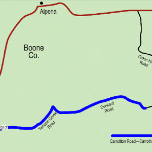 Carrollton Road
501-918-3025
calsfoundation@cals.org
calsfoundation@cals.org
The Carrollton Road was part of an east-west road that crossed northern Arkansas in the 1830s and is noteworthy as one of the few documented roads used by the John Benge Detachment of Cherokee during the Indian Removal of the late 1830s. A segment of the road survives today.
The Cherokee Removal detachment led by Captain John Benge initially consisted of 1,079 people and seventy wagons, though others would join the group as it headed west. The detachment departed from Fort Payne, Alabama, in late September and early October 1838. It crossed into Tennessee and later crossed the Mississippi River at Iron Banks in Kentucky. Traveling west and southwest through Missouri on the Military Road, the detachment crossed into Arkansas at Hix’s Ferry on the Current River; the crossing probably occurred on December 8, 1838.
The detachment camped at Fourche Dumas on December 9 before heading toward the White River. It crossed the Eleven Point River at Black’s Ferry, which had been established around 1815 by David Black, before proceeding to the Spring River and passing by the village of Jackson, then in Lawrence County. It traveled through Smithville (Lawrence County) on December 12, with one observer noting that “the whole company appeared to be well clothed, and comfortably fixed for traveling.” However, he added, “It is stated that they have the measles and whooping cough among them and there is an average of four deaths per day.”
The group apparently split north of Batesville (Independence County) on December 15, with some going into Batesville “to get their carriages repaired, horses shod, &c.&c.” while the remainder continued to the west. The travelers rested near Old Athens in Izard County before reuniting and continuing their journey, traveling northwest above the White River toward Talbert’s Ferry, crossing the river in late December 1838.
The detachment continued west, traveling through Carrollton (Carroll County) along the surviving road segment, most likely, in early January. Benge’s detachment continued through Osage (Carroll County), Huntsville (Madison County), and Fayetteville (Washington County) before entering Indian Territory, where the group disbanded on January 17, 1839, having traveled some 768 miles.
The surviving road segment—located on modern-day Carroll County Road 917, Terrapin Creek Road, and Dunkard Road between U.S. Highway 412 and Green Hill Road—precisely follows the road drawn of the 1837 Government Land Office map for Township 19 North, Range 21 West, which led from the intersection of the Carrollton to Yellville Road and a second road that connected with a road from Yellville (Marion County) to Forsythe, Missouri.
The John Benge Detachment’s route through northern Arkansas has been one of the most difficult for researchers to pinpoint, largely because of the lack of documentary materials outlining the journey. However, all major sources agree that the detachment traveled through Carrollton, and based on the 1837 Government Land Office map of the region, the Carrollton Road—Carrollton Segment was the only road through town at the time of Indian Removal. It was listed on the National Register of Historic Places on May 20, 2008.
For additional information:
“Carrollton Road—Carrollton Segment.” National Register of Historic Places nomination form. On file at Arkansas Historic Preservation Program. Online at http://www.arkansaspreservation.com/National-Register-Listings/PDF/BO0203.nr.pdf (accessed September 29, 2021).
Dalton, Lawrence. History of Randolph County, Arkansas. Little Rock: Democrat Printing and Lithography Co., 1946.
The Goodspeed Biographical and Historical Memoirs of Northwestern Arkansas. Chicago: Goodspeed Publishing Co., 1889.
King, Duane. “Cherokee Emigration Routes through Northern Arkansas during the Forced Removal of 1838–1839.” Research report, June 7, 2002. On file at Arkansas Historic Preservation Program, Little Rock, Arkansas.
Mark K. Christ
Arkansas Historic Preservation Program


Comments
No comments on this entry yet.