 Historic Preservation
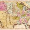 Louisiana Purchase through Early Statehood, 1803 through 1860
 Transportation
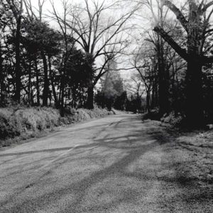 Dover to Clarksville Road
501-918-3025
calsfoundation@cals.org
calsfoundation@cals.org
The Dover to Clarksville Road is an early nineteenth-century road through what is now Pope and Johnson counties. A surviving segment of the road is significant for its connections with routes taken during the Indian Removals of the 1830s. That segment—located on Hickeytown Road east of U.S. Highway 64 near present-day Lamar (Johnson County)—was listed on the National Register of Historic Places on May 26, 2005.
In March 1834, Lieutenant Joseph Whipple Harris left the eastern United States with a party of 125 Cherokee and set out for the Indian Territory, picking up hundreds of other emigrant Cherokee before crossing the Mississippi River and entering Arkansas. His detachment numbered more than 500, many of them ill with measles and other diseases, before arriving at Little Rock (Pulaski County) on April 6. The party continued on to the Cadron (Faulkner County) settlement, where a virulent outbreak of cholera killed dozens of Cherokee.
On April 26, Harris, himself suffering from cholera, moved the detachment west across Cadron Creek, crossing Point Remove Creek on April 28. The following day, he considered three possible routes to follow to Indian Territory: the Military Road (also known as the Little Rock to Cantonment Gibson Road) south of the Arkansas River, and the upper and lower roads north of the river. Ultimately, he decided on the upper road—including the Dover to Clarksville Road—writing: “The upper road & new cut make, it is said, as direct a route as the military road. It will expose me to no delays, & of ferrying, there are good fords across the Illinois & the Piney, & though the new cut is nothing more than a blazed way through the woods—not a wagon track visible—very rough and here and there boggy, it will shorten our distance, including the delays of ferriage, a day’s journey; & will carry us through one or two flourishing settlements where I am sure of obtaining corn and bacon.”
The upper road that Harris described on April 29, 1834, does not appear on the 1829 Government Land Office map for Township 9 North, Range 22 West. However, it does appear as a trace connecting the communities of Dover (Pope County) and Clarksville (Johnson County) on an 1844 Arkansas map by M. Breese, perhaps reflecting improvements made in the ensuing decade. Another map made by A. Mitchell in 1849 clearly shows the road, which was a recognized thoroughfare by that time. The current appearance of the road most likely reflects its appearance at the time that two later detachments traveled on it.
The Harris Detachment would have traversed the Hickeytown Road Segment on May 2, when he recorded in his journal that he had “reached Parks near Piney 10 AM. Encamped at 4m/Beyond P’s on the ridge. Tolerable range and good water.” This ridge would have been at present-day Lamar, just west of the National Register segment.
On May 10, the Harris Detachment arrived at New Dwight Mission in the Indian Territory. Of the more than 500 Cherokee in the party, eighty-one died during the journey, and others later perished from the lingering effects of the hard journey and illness. Harris himself would die in 1837, his health destroyed by the cholera he suffered at Cadron.
The next detachment to travel the Dover to Clarksville Road, a party of 875 Cherokee under Lt. R. H. K. Whiteley, left Chattanooga, Tennessee, on June 13, 1838. Traveling by water, the group entered the Arkansas River via the White River cutoff on July 4, then proceeded to Little Rock.
After switching to a lighter-draft steamboat, the Tecumseh, in order to navigate the drought-reduced Arkansas River west of Little Rock, the party proceeded on July 12 as far as Lewisburg (Conway County), in the vicinity of modern-day Morrilton (Conway County), where they grounded on Benson’s Bar. On July 20, Whiteley procured twenty-three wagons and continued toward Indian Territory, leaving eighty sick Cherokee behind. He wrote in his journal the next day: “Procured more wagons and started the balance, much sickness & increasing, three, four, & five deaths per day. Diseases, measles & flux—caused by the use of green peaches & corn.”
The Whiteley Detachment continued moving west, covering from seven to sixteen miles each day as the brutal Arkansas heat continued to take its toll on the ailing Cherokee. The party would have traveled the Hickeytown Road Segment on July 25 or 26; Whiteley’s journal entry for July 25 says: “Started the party before sunrise & encamped for the night at Piney.” While there, Josiah Giles and Dr. Robert Hodsden lodged at “Moreland’s on Piney Creek,” most likely the home of Jeremiah Moreland.
The detachment entered the Indian Territory on August 4, having traveled 1,554 miles, and Whiteley turned them over to an agent there on August 5. His last journal entry reads: “Turned over the detachment to Mr. C. Nan as directed by Captain Stephenson and found the party in following size: 602 Indians present; 65 Indians left the party, and went into the Nation after crossing the line. 70 deaths on the journey.”
The last group to travel on the Dover to Clarksville Road were Cherokee who had signed the Treaty of New Echota and traveled separately from their fellow tribesmen. Mixed-blood Cherokee John Bell conducted the detachment, and U.S. Army Lieutenant Edward Deas served as chief administrator. The detachment of around 660 Indians left the emigrating depot at Fort Cass near Charleston, Tennessee, on October 10, 1838.
Deas reported that the Bell Detachment had crossed the Mississippi River by November 24, 1838. Deas’s expense vouchers show that the party crossed Blackfish Lake on November 28, when he paid H. N. Ferguson to ferry the Cherokee across. Vouchers from late November show that the party purchased supplies from William Strong, and that Strong ferried 650 Cherokee across the St. Francis River.
The Bell Detachment reached Little Rock by December 14 and stayed for three days, then followed the Military Road west. They reached Cadron on December 21 and crossed Cadron Creek the next day. They followed the Military Road as far as Lewisburg, then followed the same roads traveled by the Harris and Whiteley Detachments. Crossing Point Remove Creek on William Ellis’s Ferry on December 25, 1838, the group would have traversed the Hickeytown Road Segment sometime before December 31, when Deas bought supplies from A. E. Pace on Horsehead Creek west of the road.
The Bell Detachment traveled 707 miles in eighty-nine days and disbanded at Vineyard Post Office—present-day Evansville (Washington County)—on January 7, 1839. Twenty-one of the 660 Cherokee Indians who began the journey in Tennessee died en route.
For additional information:
Breese, M. Arkansas 1844. Map. Arkansas State Archives, Little Rock, Arkansas.
“Dover to Clarksville Road—Hickeytown Road Segment.” National Register of Historic Places nomination form. On file at Arkansas Historic Preservation Program, Little Rock, Arkansas. Online at http://www.arkansaspreservation.com/National-Register-Listings/PDF/JO0110.nr.pdf (accessed September 29, 2021).
Foreman, Grant. Indian Removal. Norman: University of Oklahoma Press, 1953.
King, Duane. “The Emigration Route of the John A. Bell Detachment of Treaty Party Cherokees within the State of Arkansas, November 25, 1838–January 7, 1839.” Research Paper, 2001. On file at Arkansas Historic Preservation Program, Little Rock, Arkansas.
———. “Punch List and Quadrangle Map Supplement for The Emigration Route of the John A. Bell Detachment of Treaty Party Cherokees within the State of Arkansas, November 25, 1838–January 7, 1839, with Notations on the Whiteley, Drane and Harris Detachments of Emigrating Cherokees.” Research Paper, 2002. On file at Arkansas Historic Preservation Program, Little Rock, Arkansas.
Mitchell, A. New Map of Arkansas, 1849. Arkansas State Archives, Little Rock, Arkansas.
Sequoyah National Research Center. University of Arkansas at Little Rock. http://ualr.edu/sequoyah/ (accessed September 29, 2021).
Mark K. Christ
Arkansas Historic Preservation Program


Comments
No comments on this entry yet.