 Early Twentieth Century, 1901 through 1940
 Historic Preservation
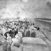 Interstate 40
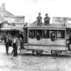 Transportation
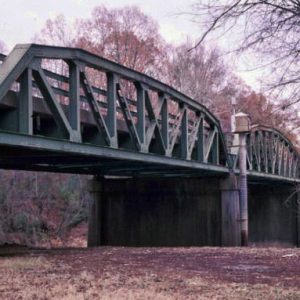 Highway 67 Bridge
 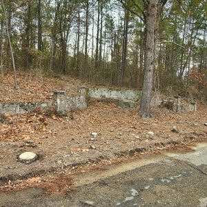 Highway 67 Rest Area
 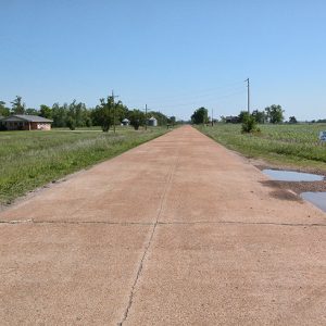 Old U.S. Highway 67
 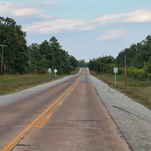 Old U.S. Highway 67
501-918-3025
calsfoundation@cals.org
calsfoundation@cals.org
Highway 67 was one of the original highways included when the Arkansas State Highway System was formed in 1923; it was also one of the first Arkansas highways to be integrated as part of the U.S. highway system in 1925. By the late 1920s, Highway 67 was in need of serious improvement. The Arkansas State Highway commission began a major effort to upgrade and improve Arkansas’s major highways, including Highway 67, through the 1930s. Five sections of the highway and one rest area from this period, as well as a bridge and a rest area, have been listed on the National Register of Historic Places.
The route of the highway followed that of the Southwest Trail of the early 1800s, which lay upon a natural path through Arkansas between the Mississippi Alluvial Plain and the Ozark Mountain foothills. In the twenty-first century, Highway 67 is a main thoroughfare between Little Rock (Pulaski County) and St. Louis, Missouri, and connects the northeastern portion of Arkansas to two main interstate systems: Interstate 40 and Interstate 30.
While Highway 67 is still a viable roadway, five sections and one rest area that have been placed on the National Register of Historic Places exhibit the evolution of roadways. The Biggers to Datto section in Randolph County, the Alicia to Hoxie section in Lawrence County, the Highway 67 Rest Area in Clark County, the Highway 67 Bridge over the Little Missouri River at the Nevada–Clark county line, and the Mandeville section in Miller County were dropped from the main route of Highway 67 as new engineering practices allowed for more expedient avenues to be built. Much of the current Highway 67 follows the original route and has been upgraded over time.
Biggers to Datto Section
The Old U.S. Highway 67 from Biggers (Randolph County) to Datto (Clay County) is a bypassed, two-lane concrete highway built in 1928–1930 and connects the towns of Biggers, Reyno (Randolph County), and Datto. The Old U.S. Highway 67 was the principal route through many small towns of Randolph and Clay counties until the current incarnation of Highway 67 was built to the southeast in 1958. The Clay County section of Highway 67 was the first to be paved, in 1928. The Arkansas State Highway Commission chose Philpot Construction Company of Pine Bluff (Jefferson County) to pave the Clay County section of Highway 67. Two years later, in 1930, the Arkansas State Highway Commission hired Phoenix Construction Company of Fort Smith (Sebastian County) to pave the Randolph County portion of Highway 67. Unlike the Alicia to Hoxie section, the Biggers to Datto section of Highway 67 was not a federal aid project but was promulgated solely by the State of Arkansas. Many smaller state highways were subsidized by the Works Progress Administration (WPA) and the Federal Emergency Relief Administration (FERA) to build and upgrade Arkansas’s roads.
Old U.S. 67 from Biggers to Datto is still in use in the twenty-first century, serving the rural communities through which it was built. This section, which still consists of its original material, was added to the National Register of Historic Places on September 24, 2004.
Alicia to Hoxie Section
The Old U.S. Highway 67 section from Alicia (Lawrence County) to Hoxie (Lawrence County) was built in two sections from 1929 to 1930. This section contains three original reinforced concrete deck girder bridges crossing Black Spice Ditch, Village Creek Relief, and Village Creek proper. The original work on this section of Old Highway 67 was not only a state project but was divided into federal aid projects. The paving was done in two sections, with that from Minturn (Lawrence County) to Hoxie first and Alicia to Minturn second. Multiple companies were contracted to work on this section of the highway: J. B. McCrary Engineering Corporation of Atlanta, Georgia, did concrete paving from Alicia to Minturn; Porter Construction Company of Tulsa, Oklahoma, did concrete paving from Minturn to Hoxie; Richardson Ayres of Hope (Hempstead County) built bridges and earth approaches from Alicia to Hoxie; and Newell Contracting Company of Little Rock did grading and built drainage structures from Alicia to Hoxie. Despite the abandonment of the majority of this section of highway, the original pavement and dimensions remain; however, some damage has occurred to two of the three original bridges. Old U.S. Highway 67 from Alicia to Hoxie was added to the National Register of Historic Places on May 18, 2003.
Highway 67 Rest Area
Built in 1936, the Old Highway 67 Rest Area was built to accommodate traveling motorists. Located between Curtis (Clark County) and Gum Springs (Clark County), this rest area consists of a retaining wall, a concrete bench, and a fieldstone well. The Arkansas Department of Transportation constructed the rest area in conjunction with the National Youth Administration (NYA). This section of Highway 67 was originally routed as Arkansas Highway 51, but the section between Curtis and Gum Springs proved to be a much more concise route. After the road between Curtis and Gum Springs was paved, it was designated a part of Highway 67, with the former route through Burtsell (Clark County) rerouted as Arkansas Highway 51. Natural erosion of the surrounding landscape has caused minimal damage to the rest area, but it remains intact and retains its original integrity. The Old U.S. 67 Rest area was added to the National Register of Historic Places on October 5, 2006.
Highway 67 Bridge over the Little Missouri River
A major distinction of Old U.S. Highway 67 is its many different bridges, one of which is a Parker Pony Truss–type bridge. This type of design, first developed by C. H. Parker in the late 1800s, consists of right triangles with a polygonal top to support longer distances. This bridge crosses the Little Missouri River at the Nevada–Clark county line. The bridge was built in 1931 as U.S. Highway 67 was reconstructed in that area. The Vincennes Bridge Company of Vincennes, Indiana, built the bridge as a part of a large contract for six other bridges along the route. The bridge is still in use and retains its original integrity. The Old U.S. Highway 67 Bridge over the Little Missouri River was added to the National Register of Historic Places on January 24, 2007.
Mandeville Section
Beginning at the intersection of Arkansas Highway 296 and 237 and ending at Miller County Road 63, the Mandeville (Miller County) section of Highway 67 was paved in 1929 and retains two original reinforced concrete deck girder bridges. These bridges cross the McKinney Bayou and Paup’s Spur Bayou. The contract to pave this section of U.S. 67 was given to McGuire and Cavender of Texarkana, Texas. The southwestern half of this alignment is still in use as Arkansas Highway 296, while the northeastern half of the alignment is abandoned and unused. This section of the highway retains its original pavement and width. The Old U.S. Highway 67 section around Mandeville was added to the National Register of Historic Places on January 21, 2004.
For additional information:
Arkansas State Highway Commission. Ninth Biennial Report of the Arkansas State Highway Commission. Russellville, AR: Russellville Printing Company, 1930.
Arkansas State Highway Commission. Tenth Biennial Report of the Arkansas State Highway Commission, 1931–1932. Russellville, AR: Russellville Printing Company, 1932.
Arkansas State Highway and Transportation Department. Historical Review: Arkansas State Highway Commission and Arkansas State Highway and Transportation Department, 1913–1992. Little Rock: Arkansas State Highway and Transportation Department, 1992.
Eriksson, Mervin, Dan Gard, and Milo C. McLeod. Identifying and Preserving Historic Bridges. Missoula, MT: U.S. Department of Agriculture, Forest Service, Missoula Technology and Development Center, 2000.
“Final Report and Physical Accomplishments of the Works Projects Administration [in] Arkansas.” Dean B. Ellis Library Archives and Special Collections. Arkansas State University, Jonesboro, Arkansas.
Hanley, Ray. A Journey through Arkansas: Historic U.S. Highway 67. Charleston, SC: Arcadia Publishing, 1999.
Hope, Holly. An Ambition to be Preferred: New Deal Recovery Efforts and Architecture in Arkansas, 1933–1943. Little Rock: Arkansas Historic Preservation Program, 2006.
“Old U.S. 67, Alicia to Hoxie.” National Register of Historic Places nomination form. On file at Arkansas Historic Preservation Program, Little Rock, Arkansas.
“Old U.S. 67, Biggers to Datto.” National Register of Historic Places nomination form. On file at Arkansas Historic Preservation Program, Little Rock, Arkansas. Online at http://www.arkansaspreservation.com/National-Register-Listings/PDF/RA0105.nr.pdf (accessed September 14, 2021).
“Old U.S. 67, Mandeville.” National Register of Historic Places nomination form. On file at Arkansas Historic Preservation Program, Little Rock, Arkansas. Online at http://www.arkansaspreservation.com/National-Register-Listings/PDF/MI0135.nr.pdf (accessed September 14, 2021).
“Old U.S. 67 Rest Area.” National Register of Historic Places nomination form. On file at Arkansas Historic Preservation Program, Little Rock, Arkansas. Online at http://www.arkansaspreservation.com/National-Register-Listings/PDF/CL0430.nr.pdf (accessed September 14, 2021).
“U.S. 67 Bridge over the Little Missouri River.” National Register of Historic Places nomination form. On file at Arkansas Historic Preservation Program, Little Rock, Arkansas. Online at http://www.arkansaspreservation.com/National-Register-Listings/PDF/CL0949.nr.pdf (accessed September 14, 2021).
The WPA Guide to 1930s Arkansas. Lawrence: University Press of Kansas, 1987.
Zachary Elledge
Jonesboro, Arkansas


Comments
No comments on this entry yet.