 Roads and Highways
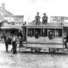 Transportation
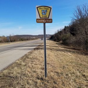 Civil War Trail
 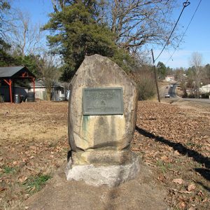 Fort Towson Trail Marker
 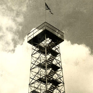 Gaylor Mountain Tower
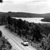
 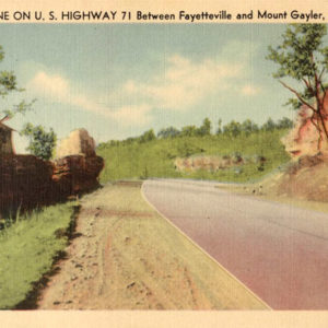 Highway 71 Postcard
 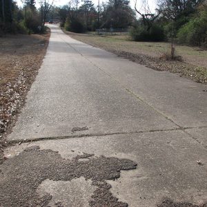 Old U.S. 71
501-918-3025
calsfoundation@cals.org
calsfoundation@cals.org
In Arkansas, U.S. Highway 71 stretches from the southwestern border of the state south of Kiblah (Miller County) to the northwestern corner north of Bella Vista (Benton County). It passes through nine counties in Arkansas, generally following an alignment of the Ozark Trail.
Route
U.S. Highway 71 extends 1,532 miles beginning near Krotz Springs, Louisiana, and passes through Louisiana, Texas, Arkansas, Missouri, Iowa, and Minnesota before ending at the U.S.-Canadian border north of Bemidji, Minnesota. The Arkansas portion is approximately 300 miles.
The highway enters Arkansas south of Kiblah as a two-lane highway heading north, passing through Doddridge (Miller County) and Fouke (Miller County) before reaching Texarkana (Miller County). At Texarkana, Highway 71 has a short concurrence with U.S. Highway 67 and U.S. Highway 82 before turning north along State Line Road where the highway straddles the Texas-Arkansas state line (northbound lanes are in Arkansas, southbound lanes are in Texas). North of Texarkana, the road crosses Interstate 30 and is joined by U.S. Highway 59 to Acorn (Polk County). Highway 71 continues to straddle the state line until it crosses the Red River near the community of Index (Miller County), where it fully reenters Arkansas. The highway then continues as a divided highway until it reaches Ashdown (Little River County).
North of Ashdown, Highway 71 continues north as a two-lane highway passing through Wilton (Little River County) and Falls Chapel (Sevier County) before meeting U.S. Highway 371 at Lockesburg (Sevier County). It continues north where it joins U.S. Highway 70 then crosses the Cossatot River, heading west toward De Queen (Sevier County). At De Queen, Highway 71 leaves U.S. 70 and again heads north, passing through Gillham (Sevier County) and Grannis (Polk County) before crossing U.S. 278 at Wickes (Polk County). Highway 71 continues north through Cove (Polk County) before shifting northwest toward Mena (Polk County). As the highway enters Mena, it turns west and passes the historic Mena Railroad Depot before again shifting north.
Highway 71 then passes through Acorn, where Highway 59 splits off toward Oklahoma, and is joined by U.S. Highway 270, crossing the Ouachita River and winding its way through the Ouachita National Forest to the community of Y City (Scott County), where Highway 270 splits off toward Hot Springs (Garland County). Highway 71 continues north and passes through Boles (Scott County) and Needmore (Scott County) before approaching Waldron (Scott County), where the highway passes to the west before continuing north.
Highway 71 then turns west through Huntington (Sebastian County) and Mansfield (Scott and Sebastian counties) before turning north again toward Witcherville (Sebastian County). Just past Witcherville, Highway 71 becomes a four-lane divided highway passing to the west of Greenwood (Sebastian County) before continuing north to Fort Smith (Sebastian County), where it intersects Interstate 540.
Highway 71 then runs concurrently with Interstate 540 for twelve miles, passing along the east side of Fort Smith before crossing the Arkansas River and passing Van Buren (Crawford County) before intersecting Interstate 40, where Highway 71 heads east toward Alma (Crawford County).
At Alma, Highway 71 continues its northerly track as it winds through the Ozark National Forest before descending into Mountainburg (Crawford County). The highway then winds through the Boston Mountains, passing Lake Fort Smith State Park and Artists’ Point (Crawford County) before ascending to the top at Mount Gaylor (Crawford County). It then descends the mountain into Winslow (Washington County) before heading north toward West Fork (Washington County) and Greenland (Washington County), where it crosses the West Fork of the White River before heading north toward Fayetteville (Washington County).
At Fayetteville, Highway 71 joins Interstate 49, bypassing much of Fayetteville, Springdale (Washington and Benton counties), Rogers (Benton County), and Bentonville (Benton County) as a four-lane limited-access highway. North of Bentonville, Highway 71 leaves Interstate 49, continuing north as a four-lane divided road passing through Bella Vista before crossing into Missouri.
History
The road that became Highway 71 started out as a hodge-podge of Native American trails. In 1827, one of the first roads in the area, the Fort Towson Trail, was established in Oklahoma Territory, stretching east to De Queen, then north toward Fort Smith. In 1860, this road would later become part of the Civil War trail from south of Texarkana to the Missouri state line.
In 1913, modern-day Highway 71 would became part of the Ozark Trail from the Louisiana state line to the Missouri state line north of Sulphur Springs (Benton County). Although originally intended to promote Coin Harvey’s Monte Ne (Benton County) resort east of Rogers, it would also be used to showcase highway design, though it would be primarily maintained by local municipalities and road districts. Before this time, most of the road was little more than deeply rutted wagon trail.
It would not be until 1924 that the Arkansas Department of Transportation would officially number roads that met the criteria for federal highway funding. Much of what would become Highway 71 was designated State Road A-4. In 1926, the federal government created the U.S. Highway system and officially designated Highway 71.
In 1960, U.S. 71 was rerouted along former Arkansas Highway 100 between Bentonville and the Arkansas state line near Bella Vista. Between Bentonville and Gravette (Benton County), the old alignment was re-designated Arkansas Highway 72, while Arkansas Highway 59 was designated between Gravette and the Missouri state line north of Sulphur Springs.
Several older portions of the highway have been placed on the National Register of Historic Places. These portions date back to between 1928 and 1934 and survive as examples of road-building techniques of that era.
For additional information:
Nelson, Rex. “Wonders of the West.” Arkansas Democrat-Gazette, February 10, 2019, pp. 1H, 6H.
“Old U.S. 71, Ashdown Segment.” National Register of Historic Places nomination form. On file at Arkansas Historic Preservation Program, Little Rock, Arkansas. Online at http://www.arkansaspreservation.com/National-Register-Listings/PDF/LR0032.nr.pdf (accessed August 27, 2020).
“Old U.S. 71, Greenland Segment.” National Register of Historic Places nomination form. On file at Arkansas Historic Preservation Program, Little Rock, Arkansas. Online at http://www.arkansaspreservation.com/National-Register-Listings/PDF/WA0922.nr.pdf (accessed August 27, 2020).
“Old U.S. 71, Jenny Lind Segment.” National Register of Historic Places nomination form. On file at Arkansas Historic Preservation Program, Little Rock, Arkansas. Online at http://www.arkansaspreservation.com/National-Register-Listings/PDF/SB1016.nr.pdf (accessed August 27, 2020).
“Old U.S. 71, Little River Approach.” National Register of Historic Places nomination form. On file at Arkansas Historic Preservation Program, Little Rock, Arkansas. Online at http://www.arkansaspreservation.com/National-Register-Listings/PDF/SV0090.nr.pdf (accessed August 27, 2020).
“Old U.S. 71, Ogden Segment.” National Register of Historic Places nomination form. On file at Arkansas Historic Preservation Program, Little Rock, Arkansas. Online at http://www.arkansaspreservation.com/National-Register-Listings/PDF/LR0135.nr.pdf (accessed August 27, 2020).
“Old U.S. 71, Wilton Segment.” National Register of Historic Places nomination form. On file at Arkansas Historic Preservation Program, Little Rock, Arkansas. Online at http://www.arkansaspreservation.com/National-Register-Listings/PDF/LR0078.nr.pdf (accessed August 27, 2020).
Historical Review, Volume Two: Arkansas State Highway Commission and Arkansas State Highway and Transportation Department, 1913–2003. Little Rock: Arkansas State Highway and Transportation Department, 2004
Wappel, Tony, and Dennis Garrison. On the Avenue: An Illustrated History of Fayetteville’s US Highway 71B. N.p.: 2015.
David Backlin
Fort Smith, Arkansas


Comments
No comments on this entry yet.