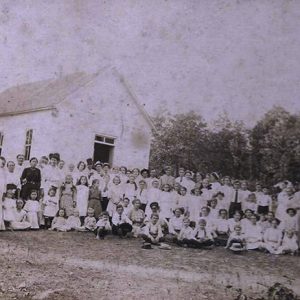
 Egner-Powell School
  Independence County Map
  Ramsey Mountain Peak
 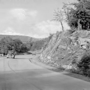 Ramsey Mountain
 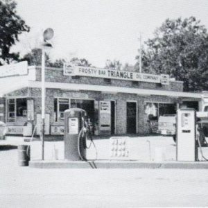 Triangle Frosty Bar
501-918-3025
calsfoundation@cals.org
calsfoundation@cals.org
Dennison Heights of Independence County began as a housing development in the 1950s and 1960s on the bluffs overlooking the White River. It was named for the Dennison/Denison family (different branches of the family spelled the name differently) who had a large farm south of the White River and across the river from Eagle Mountain. Dennison Heights is located three miles south of Batesville (Independence County), the county seat. It sits atop Ramsey Mountain (a.k.a. Ramsey Hill), just off Highway 167, also called Batesville Boulevard.
At the time of Dennison Heights’ formation, three roads made a triangle at the “top of the hill,” as the Dennison Heights area is commonly called: Highways 14 and 25 led to Desha (Independence County) and Locust Grove (Independence County), the McHue Road led to McHue (Independence County), while Batesville Boulevard and Highway 14 led to Southside (Independence County) and Allen Chapel (Independence County). Where the three highways split is called “the Triangle.” The top of the hill is home to a commercial area.
Ramsey Mountain, Ramsey Bottoms (located between the mountain and the White River at Batesville), and Ramsey Slough, which is a popular fishing and boating inlet of the river, are all named for Allen Dunn Ramsey (1822–1878). Ramsey owned and operated Ramsey’s Ferry across the White River, about where the Highway 167 bridge crosses the river in the twenty-first century. Ramsey owned many acres of farm land on the White River and in the Greenbrier Bottoms near Locust Grove. He married Helen Slater in 1846, and they raised a family in a house near the foot of Ramsey Mountain; the family later lived in Ruddell (Independence County). Ramsey’s father, William Ramsey, had settled in Batesville, then called Poke (or Polk) Bayou, with three other families. Ramsey’s Ferry continued to operate following Allen Ramsey’s death until a bridge across the White River at Batesville was built in 1928.
By the mid-1880s, Walter Henderson Denison had begun work with the Keystone Mining Company at Cushman (Independence County). Manganese mining was becoming a major economic activity in the county. Following the death of his first wife, Mary Shell, Denison married Mabel Driskill of Rosie (Independence County) and started a new family. A year after his second marriage, Denison bought a 1,000-acre farm south of the White River and across the river from Eagle Mountain, southeast of Batesville. Dennison Heights took shape from this settlement after Denison’s death in 1949.
Most young people in the region went to the Egner-Powell School, the Salem School, or Salado (Independence County) schools. The three schools—Egner-Powell, Salem, and Salado—together with Baker, were consolidated with the new school at Southside in the 1948–49 school year. The top of the hill served as the district line for the Desha and Southside schools, with Dennison Heights in the Southside School District. Desha consolidated with the Batesville School District in 1985.
The Batesville Regional Airport, located at Southside but owned by the City of Batesville, is a mile from Dennison Heights, south on Batesville Boulevard. The airport opened on December 1, 1944, as a grassy runway for small private planes and expanded in 1970 into one of the larger airports in Arkansas. The airport occupies 398 acres and maintains two asphalt-paved runways. Country singer Jim Reeves and his piano player and manager Dean Manuel left from this airport on July 31, 1964, to fly back to Nashville, Tennessee; the plane crashed near Brentwood, Tennessee, killing both men.
The arrangement of highways at the top of the hill changed to form a new triangle, as the McHue Road was closed because of the 1970 Batesville Regional Airport expansion. The Desha and Locust Grove roads were re-routed. The portion of the McHue Road that was replaced is called the Runway Road; it is not a through road and has limited access.
There are no religious establishments in Dennison Heights, but the Allen Chapel Free Will Baptist Church is nearby. Though several businesses have been located at the top of the hill over the years—including a trailer sales company, a real estate office, a service station, a drive-in eatery, a bank, and a scenic motel—the mainstay Triangle Cafe (which has a Batesville address) is the leading attraction to the area for travelers and locals. Owned and operated for many years by Offie Edmondson and Effie McClendon Edmondson, who lived in a trailer near the service station that used to be with the restaurant, the Triangle (and its Frosty Bar) served as a popular gathering place for teens and adults of the region, especially in the 1950s and 1960s. Charles Edward (Charlie) Bullard helped Offie Edmondson run the service station for several years until he opened his own station across the highway.
For additional information:
Biographical and Historical Memoirs of Northeast Arkansas. Chicago: Goodspeed Publishing Co., 1889.
McGinnis, A. C. “A History of Independence County, Ark.” Special issue. Independence County Chronicle 17 (April 1976).
Kenneth Rorie
Van Buren, Arkansas


I enjoyed reading the article about Ramsey Mountain. I was born in Sulfur Rock in 1947. We moved to Indianapolis in 1950. We would visit Batesville every summer where my grandfather Alfred Tommie Henderson and my grandmother Lizzie Henderson lived. My dad would tell me about when he would ride his bicycle down Ramsey Mountain, which at the time (1930s-early 1940s) may have not been paved. I always thought that would be one hell of a ride.